Lynch Quarry site
United States historic place
Lynch Quarry site | |
U.S. National Historic Landmark | |
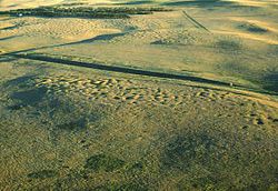 Aerial view of the site (National Park Service photo) | |
   | |
| Nearest city | Dunn Center[2] |
|---|---|
| Area | 690 acres (280 ha) |
| NRHP reference No. | 11000629[1] |
| Significant dates | |
| Added to NRHP | July 13, 2011 |
| Designated NHL | July 13, 2011 |
The Lynch Quarry site, also known as the Lynch Knife River Flint Quarry, and designated by the Smithsonian trinomial 32DU526, is a historic pre-Columbian flint quarry located near Dunn Center, North Dakota, United States.[2] The site was a major source of flint found at archaeological sites across North America, and it has been estimated that the material was mined there from 11,000 B.C. to A.D. 1600. The site was designated a National Historic Landmark in 2011.[3][4][5][6]
Knife River flint was a prized toolmaking material among North America's prehistoric population, as it is particularly easy to work into projectile points, knives, and scraping tools. Materials from Knife River quarries have been found at prehistoric archaeological sites in Northern Canada, New York, and New Mexico, and would have been traded by area tribes for other materials such as shell, obsidian, cloth, and (in the early European contact period) metal weapons.[7] The Lynch site, whose known extent is at least 690 acres (280 ha) has an estimated 20,000 pits from which flint was quarried. The pits range in depth from 3 to 10 feet (0.91 to 3.05 m), and are accompanied by spoil piles. It is located on the banks Spring Creek, a tributary of the Knife River.[8] The site is remarkably well preserved, despite agricultural activity over parts of it, and the digging of shafts for coal mining in some areas. At the time of the site's nomination as a National Historic Landmark, detailed examination of the site for specific work areas had not taken place; the entire site is covered with chipped and flaked stone.[2]
See also
- List of National Historic Landmarks in North Dakota
- National Register of Historic Places listings in Dunn County, North Dakota
References
- ^ "Weekly List Of Actions Taken On Properties: 7/18/11 Through 7/22/11" (pdf). Retrieved July 17, 2014.
- ^ a b c "Lynch Quarry Site" (PDF). National Historic Landmark Nomination (redacted 2011 draft). Archived from the original on July 8, 2011. Retrieved August 11, 2013.
{{cite web}}: CS1 maint: unfit URL (link) - ^ "North Dakota's Knife River flint quarry named National Historic Landmark". The Bismarck Tribune. June 6, 2012.
- ^ NPS NHL list for North Dakota
- ^ "More information on Lynch Knife River Flint Quarry NHL". Midwest Archeological Center. August 2, 2011.
- ^ Lauren Donovan (August 2, 2011). "Ancient flint quarries near Dunn Center named national landmark". The Bismarck Tribune.
- ^ "Knife River Indian Villages National Historic Site: Geologic Resources Inventory Report" (PDF). National Park Service. Retrieved November 10, 2015.
- ^ "November 2010 Archeology E-Gram" (PDF). National Park Service. Retrieved November 10, 2015.
- v
- t
- e
- Periods
- Lithic
- Archaic
- Formative
- Classic
- Post-Classic
cultures
- Adena
- Alachua
- Ancient Beringian
- Ancestral Pueblo (Anasazi)
- Anishinaabe
- Avonlea
- Baytown
- Belle Glade
- Buttermilk Creek complex
- Caborn-Welborn
- Cades Pond
- Calf Creek
- Caloosahatchee
- Clovis
- Coles Creek
- Comondú
- Deptford
- Folsom
- Fort Ancient
- Fort Walton
- Fremont
- Glacial Kame
- Glades
- Hohokam
- Hopewell
- La Jolla
- Las Palmas
- Maritime Archaic
- Mississippian
- Mogollon
- Monongahela
- Old Cordilleran
- Oneota
- Paleo-Arctic
- Paleo-Indians
- Patayan
- Plano
- Plaquemine
- Poverty Point
- Red Ocher
- Safety Harbor
- Santa Rosa-Swift Creek
- St. Johns
- Steed-Kisker
- Suwannee Valley
- Tchefuncte
- Troyville
- Weeden Island
sites
- Angel Mounds
- Anzick site
- Bandelier National Monument
- Bastian
- Benson
- Blue Spring Shelter
- Bluefish Caves
- The Bluff Point Stoneworks
- Brewster
- Cahokia
- Candelaria Cave
- Casa Grande
- Chaco Canyon
- Coso Rock Art District
- Crystal River
- Cuarenta Casas
- Cueva de la Olla
- Cutler
- Eaker
- El Fin del Mundo
- El Vallecito
- Effigy Mounds
- Etowah Indian Mounds
- Eva
- Folsom
- Fort Ancient
- Fort Center
- Fort Juelson
- Four Mounds
- Gila Cliff Dwellings
- Glenwood
- Grimes Point
- Helen Blazes
- Holly Bluff
- Hopewell Culture National Historical Park
- Horr's Island
- Huápoca
- Key Marco
- Kimball Village
- Kincaid Mounds
- Kolomoki Mounds
- Lake Jackson Mounds
- Lehner Mammoth-Kill Site
- L'Anse aux Meadows
- Lynch Quarry Site
- Marksville
- Marmes Rockshelter
- Meadowcroft Rockshelter
- Mesa Verde
- Moaning Cavern
- Moorehead Circle
- Morrison Mounds
- Moundville
- Mummy Cave
- Nodena site
- Ocmulgee Mounds
- Old Stone Fort
- Orwell site
- Paquime
- Painted Bluff
- Parkin Park
- Pinson Mounds
- Plum Bayou Mounds
- Portsmouth Earthworks
- Poverty Point
- Pueblo Bonito
- Rassawek
- Recapture Canyon
- River Styx
- Roberts Island
- Rock Eagle
- Rock Hawk
- Rosenstock Village
- Russell Cave
- Salmon Ruins
- Serpent Mound
- Sierra de San Francisco
- Shell ring sites
- Spiro Mounds
- Stallings Island
- SunWatch
- Taos Pueblo
- Town Creek Indian Mound
- Turkey River Mounds
- Upward Sun River
- Velda Mound
- West Oak Forest Earthlodge
- Wickiup Hill
- Windover
- Winterville
- Wupatki
remains
- Aridoamerica
- Ballgame
- Black drink
- Ceremonial pipe
- Chunkey
- Clovis point
- Container Revolution
- Eastern Agricultural Complex
- Eden point
- Effigy mound
- Falcon dancer
- Folsom point
- Green Corn Ceremony
- Horned Serpent
- Kiva
- Medicine wheel
- Metallurgy
- Mi'kmaq hieroglyphic writing
- Mound Builders
- N.A.G.P.R.A.
- Norse colonization of North America
- Oasisamerica
- Piasa
- Projectile point
- Southeastern Ceremonial Complex
- Stickball
- Three Sisters agriculture
- Thunderbird
- Transoceanic contact
- Underwater panther
- Water glyphs
- Related
- Genetic history
- Pre-Columbian era
| |
|---|---|
| Topics | |
| Lists by state |
|
| Lists by insular areas | |
| Lists by associated state | |
| Other areas | |
| Related | |
| |


47°21′12″N 102°37′22″W / 47.35333°N 102.62278°W / 47.35333; -102.62278


