Water glyphs
Type of petroglyph
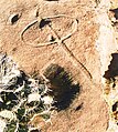
Water glyphs are a recurring type of petroglyph found across the American southwest, but primarily in southern Utah, northern Arizona, and Nevada. The symbols are thought to be of ancient origin (perhaps created by the Ancestral Puebloans) and have been dated using x-ray fluorescence to around 2000 years. Classification as a water glyph requires the presence of certain distinctive characteristics including both visual elements and location. Although the glyphs have likely been previously noted by local ranchers and farmers, the recurring pattern was first documented in 1997.[1][2]
To date, more than 370 instances of these petroglyphs had been cataloged in an extensive GIS study.[3]
Visual elements

Water glyphs are usually 48 inches long by 24 inches wide, with grooves carved half an inch to an inch deep.
- The symbol consists of a circle or ellipse bisected by a single straight line.
- The line usually extends beyond the edge of the circle on one side by a distance roughly equal to the diameter of the circle.
- Sometimes the extending line drops off the edge of the cliff or rock.
- The petroglyph usually contains a single deep depression, or "dot", within or near the circle.
Examples:
-
 Basic glyph
 -
 Double "front" horizon and multiple "dots"
 -
 Double horizion


The position of the dot with respect to the glyph varies:
- It may be found outside or within the circle.
- It may be found to the right or left of the bisecting line.
- It may be found along one of the circular "horizon" lines.
The circle may also contain additional arcs or partial arcs, forming a crescent on one side of the ring, or a double ellipse; but the basic glyph remains the same.
Location
Many petroglyphs and pictographs are located on cliff faces or under vertical overhangs, where they receive some limited protection from the elements. Water glyphs, however, typically lie along horizontal cliff edges or exposed rock surfaces. Occurrences of water glyphs are sometimes associated with the presence of Moki steps.
Theories
In consideration of the orientations of the line and circle motifs within the pictographs, the authors of this research conclude that waterglyphs are directional markers pointing toward sources of water throughout the arid Arizona Strip.
Amateur archaeologists Robert Ford and Dixon Spendlove assert that the symbols were used by the ancient Pueblo peoples to mark springs or other important travel information in the desert. They assert that a high percentage of these symbols indicates line-of-sight directions to finding a natural spring, water pocket or pool, or ancient village site. They hypothesize that the symbols could be followed, from one water source to the next, across the entire Arizona Strip.
Opposing theories include use of these petroglyphs as astronomical/solstice markers, sacrificial altars or writings left by early Spanish explorers.[citation needed]
References
- ^ "WATER TRAILS OF THE ANASAZI", June 25th 1997 @ Udvar-Hazy business building server (http://144.38.20.128/cody/bobby.html) on the Dixie State College Campus.
- ^ Robert Ford and Dixon Spendlove waterglyph research.
- ^ Robert Ford, Dixon & Cody Spendlove, David Maxwell, Gordon Hutchings (Oct 2004), Waterglyphs: Ancient Cartography of the Arizona Strip, Utah Rock Art, Volume 24, page 29, edited by Carol B. Patterson.
Publications
- First publication of the research, January 1997
- Waterglyphs: Ancient Cartography of the Arizona Strip published in the September 2004 URARA Symposium Journal
- In Situ: Newsletter of the Nevada Archaeological Association, 2006. Vol 10, No. 2.
External links
- Waterglyphs website
- Wilderness Utah - Water Trails of the Anasazi
- v
- t
- e
- Periods
- Lithic
- Archaic
- Formative
- Classic
- Post-Classic
cultures
- Adena
- Alachua
- Ancient Beringian
- Ancestral Pueblo (Anasazi)
- Anishinaabe
- Avonlea
- Baytown
- Belle Glade
- Buttermilk Creek complex
- Caborn-Welborn
- Cades Pond
- Calf Creek
- Caloosahatchee
- Clovis
- Coles Creek
- Comondú
- Deptford
- Folsom
- Fort Ancient
- Fort Walton
- Fremont
- Glacial Kame
- Glades
- Hohokam
- Hopewell
- La Jolla
- Las Palmas
- Maritime Archaic
- Mississippian
- Mogollon
- Monongahela
- Old Cordilleran
- Oneota
- Paleo-Arctic
- Paleo-Indians
- Patayan
- Plano
- Plaquemine
- Poverty Point
- Red Ocher
- Safety Harbor
- Santa Rosa-Swift Creek
- St. Johns
- Steed-Kisker
- Suwannee Valley
- Tchefuncte
- Troyville
- Weeden Island
sites
- Angel Mounds
- Anzick site
- Bandelier National Monument
- Bastian
- Benson
- Blue Spring Shelter
- Bluefish Caves
- The Bluff Point Stoneworks
- Brewster
- Cahokia
- Candelaria Cave
- Casa Grande
- Chaco Canyon
- Coso Rock Art District
- Crystal River
- Cuarenta Casas
- Cueva de la Olla
- Cutler
- Eaker
- El Fin del Mundo
- El Vallecito
- Effigy Mounds
- Etowah Indian Mounds
- Eva
- Folsom
- Fort Ancient
- Fort Center
- Fort Juelson
- Four Mounds
- Gila Cliff Dwellings
- Glenwood
- Grimes Point
- Helen Blazes
- Holly Bluff
- Hopewell Culture National Historical Park
- Horr's Island
- Huápoca
- Key Marco
- Kimball Village
- Kincaid Mounds
- Kolomoki Mounds
- Lake Jackson Mounds
- Lehner Mammoth-Kill Site
- L'Anse aux Meadows
- Lynch Quarry Site
- Marksville
- Marmes Rockshelter
- Meadowcroft Rockshelter
- Mesa Verde
- Moaning Cavern
- Moorehead Circle
- Morrison Mounds
- Moundville
- Mummy Cave
- Nodena site
- Ocmulgee Mounds
- Old Stone Fort
- Orwell site
- Paquime
- Painted Bluff
- Parkin Park
- Pinson Mounds
- Plum Bayou Mounds
- Portsmouth Earthworks
- Poverty Point
- Pueblo Bonito
- Rassawek
- Recapture Canyon
- River Styx
- Roberts Island
- Rock Eagle
- Rock Hawk
- Rosenstock Village
- Russell Cave
- Salmon Ruins
- Serpent Mound
- Sierra de San Francisco
- Shell ring sites
- Spiro Mounds
- Stallings Island
- SunWatch
- Taos Pueblo
- Town Creek Indian Mound
- Turkey River Mounds
- Upward Sun River
- Velda Mound
- West Oak Forest Earthlodge
- Wickiup Hill
- Windover
- Winterville
- Wupatki
remains
- Aridoamerica
- Ballgame
- Black drink
- Ceremonial pipe
- Chunkey
- Clovis point
- Container Revolution
- Eastern Agricultural Complex
- Eden point
- Effigy mound
- Falcon dancer
- Folsom point
- Green Corn Ceremony
- Horned Serpent
- Kiva
- Medicine wheel
- Metallurgy
- Mi'kmaq hieroglyphic writing
- Mound Builders
- N.A.G.P.R.A.
- Norse colonization of North America
- Oasisamerica
- Piasa
- Projectile point
- Southeastern Ceremonial Complex
- Stickball
- Three Sisters agriculture
- Thunderbird
- Transoceanic contact
- Underwater panther
- Water glyphs
- Related
- Genetic history
- Pre-Columbian era


