National Register of Historic Places listings in Richardson County, Nebraska

This is a list of the National Register of Historic Places listings in Richardson County, Nebraska.
This is intended to be a complete list of the properties and districts on the National Register of Historic Places in Richardson County, Nebraska, United States. The locations of National Register properties and districts for which the latitude and longitude coordinates are included below, may be seen in a map.[1]
There are 13 properties and districts listed on the National Register in the county, including 1 National Historic Landmark.
This National Park Service list is complete through NPS recent listings posted September 13, 2024.[2]
Map all coordinates using OpenStreetMap
Download coordinates as:
- KML
- GPX (all coordinates)
- GPX (primary coordinates)
- GPX (secondary coordinates)
Current listings
| [3] | Name on the Register | Image | Date listed[4] | Location | City or town | Description |
|---|---|---|---|---|---|---|
| 1 | R.A. Clark House |  | July 7, 2015 (#15000395) | 805 Vine St. 40°14′09″N 95°46′22″W / 40.235953°N 95.772700°W / 40.235953; -95.772700 (R.A. Clark House) | Stella | |
| 2 | Falls City Commercial Historic District |  | December 31, 2013 (#13001023) | Roughly Stone St. from 15th to 19th Sts. 40°03′42″N 95°36′10″W / 40.0618°N 95.6029°W / 40.0618; -95.6029 (Falls City Commercial Historic District) | Falls City | |
| 3 | Gehling's Theatre |  | September 28, 1988 (#88000942) | 1519 Stone St.[5] 40°03′38″N 95°36′11″W / 40.06047°N 95.60319°W / 40.06047; -95.60319 (Gehling's Theatre) | Falls City | |
| 4 | John Holman House | 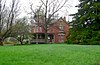 | April 25, 1972 (#72000756) | 947 Nemaha St. 40°10′12″N 95°56′44″W / 40.169991°N 95.945428°W / 40.169991; -95.945428 (John Holman House) | Humboldt | |
| 5 | Humboldt Commercial Historic District |  | September 7, 2005 (#05000999) | Western Square of 4th St. to Eastern Square, to 3rd St. 40°09′48″N 95°56′48″W / 40.163333°N 95.946667°W / 40.163333; -95.946667 (Humboldt Commercial Historic District) | Humboldt | |
| 6 | Leary Site |  | October 15, 1966 (#66000449) | Southern half of Section 33 and western half of Section 34, Township 1 North, Range 18 East[6] 40°00′06″N 95°23′42″W / 40.001667°N 95.395000°W / 40.001667; -95.395000 (Leary Site) | Rulo | |
| 7 | Miles Ranch | 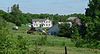 | December 19, 2012 (#12001075) | 63795 638 Ave. 40°05′21″N 95°51′38″W / 40.0893°N 95.8606°W / 40.0893; -95.8606 (Miles Ranch) | Dawson | |
| 8 | Mount Zion Brick Church |  | December 1, 1988 (#88002763) | Northwest of Barada: 718 Rd. and 651 Ave.[7] 40°13′58″N 95°36′56″W / 40.23275°N 95.61569°W / 40.23275; -95.61569 (Mount Zion Brick Church) | Barada | |
| 9 | Richardson County Courthouse |  | July 5, 1990 (#90000965) | Courthouse Sq. 40°03′44″N 95°36′08″W / 40.062222°N 95.602222°W / 40.062222; -95.602222 (Richardson County Courthouse) | Falls City | |
| 10 | Alfred and Magdalena Schmid Farmstead |  | November 16, 2005 (#05001292) | South-southwest of Dawson 40°01′40″N 95°52′56″W / 40.027778°N 95.882222°W / 40.027778; -95.882222 (Alfred and Magdalena Schmid Farmstead) | Dawson | |
| 11 | Site No. RH00-062 |  | June 19, 1987 (#87001001) | 6½ miles southeast of Rulo; 200 feet west of the road between Rulo and White Cloud, Kansas 40°00′00″N 95°19′55″W / 40.0000°N 95.331944°W / 40.0000; -95.331944 (Site No. RH00-062) | Rulo | Extends into Doniphan County, Kansas |
| 12 | Way Side Stock Farm | 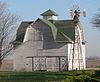 | March 17, 2015 (#15000090) | 64480 718 Rd. 40°14′00″N 95°43′57″W / 40.233333°N 95.732464°W / 40.233333; -95.732464 (Way Side Stock Farm) | Stella vicinity | |
| 13 | Gov. Arthur J. Weaver House | 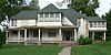 | April 27, 2005 (#05000356) | 1906 Fulton St. 40°03′51″N 95°35′43″W / 40.06422°N 95.59528°W / 40.06422; -95.59528 (Gov. Arthur J. Weaver House) | Falls City |
Former listing
| [3] | Name on the Register | Image | Date listed | Date removed | Location | City or town | Description |
|---|---|---|---|---|---|---|---|
| 1 | Rulo Bridge |  | January 4, 1993 (#92000718) | November 16, 2015 | U.S. Route 159 over the Missouri River 40°03′14″N 95°25′14″W / 40.053889°N 95.420556°W / 40.053889; -95.420556 (Rulo Bridge) | Rulo | Spanned the Missouri River to Holt County, Missouri. The bridge was demolished in two events, January 19 and February 5, 2015, after a new bridge had been built. |
See also
Wikimedia Commons has media related to National Register of Historic Places in Richardson County, Nebraska.
- List of National Historic Landmarks in Nebraska
- National Register of Historic Places listings in Nebraska
References
- ^ The latitude and longitude information provided in this table was derived originally from the National Register Information System, which has been found to be fairly accurate for about 99% of listings. Some locations in this table may have been corrected to current GPS standards.
- ^ National Park Service, United States Department of the Interior, "National Register of Historic Places: Weekly List Actions", retrieved September 13, 2024.
- ^ a b Numbers represent an alphabetical ordering by significant words. Various colorings, defined here, differentiate National Historic Landmarks and historic districts from other NRHP buildings, structures, sites or objects.
- ^ The eight-digit number below each date is the number assigned to each location in the National Register Information System database, which can be viewed by clicking the number.
- ^ See photos in D. Layne Ehlers, "National Register of Historic Places Registration Form: Gehling's Theatre"[usurped], Nebraska State Historical Society[usurped], retrieved 2013-06-10, for use as True Value hardware store; see "True Value Hardware, Falls City, NE", retrieved 2013-06-10, for address.
- ^ Corbyn, Ronald C. National Register of Historic Places Inventory/Nomination: Leary Site. National Park Service, 1975-02-16, 2.
- ^ See photo.
- v
- t
- e

- Adams
- Antelope
- Arthur
- Banner
- Blaine
- Boone
- Box Butte
- Boyd
- Brown
- Buffalo
- Burt
- Butler
- Cass
- Cedar
- Chase
- Cherry
- Cheyenne
- Clay
- Colfax
- Cuming
- Custer
- Dakota
- Dawes
- Dawson
- Deuel
- Dixon
- Dodge
- Douglas
- Dundy
- Fillmore
- Franklin
- Frontier
- Furnas
- Gage
- Garden
- Garfield
- Gosper
- Grant
- Greeley
- Hall
- Hamilton
- Harlan
- Hayes
- Hitchcock
- Holt
- Hooker
- Howard
- Jefferson
- Johnson
- Kearney
- Keith
- Keya Paha
- Kimball
- Knox
- Lancaster
- Lincoln
- Logan
- Loup
- Madison
- McPherson
- Merrick
- Morrill
- Nance
- Nemaha
- Nuckolls
- Otoe
- Pawnee
- Perkins
- Phelps
- Pierce
- Platte
- Polk
- Red Willow
- Richardson
- Rock
- Saline
- Sarpy
- Saunders
- Scotts Bluff
- Seward
- Sheridan
- Sherman
- Sioux
- Stanton
- Thayer
- Thomas
- Thurston
- Valley
- Washington
- Wayne
- Webster
- Wheeler
- York
- Bridges
- Historic districts
- Houses
- National Historic Landmarks
- Properties of religious function
- Railway stations
 Category
 List
List National Register of Historic Places Portal


Municipalities and communities of Richardson County, Nebraska, United States | ||
|---|---|---|
County seat: Falls City | ||
| Cities |  | |
| Villages | ||
| Unincorporated communities | ||
| Indian reservations | ||
| Footnotes | ‡This populated place also has portions in an adjacent county or counties | |
| ||


