National Register of Historic Places listings in Colfax County, Nebraska
This is a list of the National Register of Historic Places listings in Colfax County, Nebraska.
This is intended to be a complete list of the properties and districts on the National Register of Historic Places in Colfax County, Nebraska, United States. The locations of National Register properties and districts for which the latitude and longitude coordinates are included below, may be seen in a map.[1]
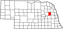
There are 13 properties and districts listed on the National Register in the county, and one former listing.
This National Park Service list is complete through NPS recent listings posted September 13, 2024.[2]
Map all coordinates using OpenStreetMap
Download coordinates as:
- KML
- GPX (all coordinates)
- GPX (primary coordinates)
- GPX (secondary coordinates)
Current listings
| [3] | Name on the Register | Image | Date listed[4] | Location | City or town | Description |
|---|---|---|---|---|---|---|
| 1 | Baumert & Bogner |  | July 25, 2022 (#100007938) | 217 Center St. 41°43′30″N 97°00′06″W / 41.7249°N 97.0018°W / 41.7249; -97.0018 (Baumert & Bogner) | Howells | |
| 2 | Colfax County Courthouse |  | September 3, 1981 (#81000369) | Off Nebraska Highway 15 41°26′49″N 97°03′18″W / 41.446944°N 97.055°W / 41.446944; -97.055 (Colfax County Courthouse) | Schuyler | |
| 3 | John Janecek House |  | July 15, 1982 (#82003185) | 805 E. 8th St. 41°26′38″N 97°03′04″W / 41.443889°N 97.051111°W / 41.443889; -97.051111 (John Janecek House) | Schuyler | |
| 4 | Merchant Park |  | October 27, 2022 (#100008313) | Corner of Higgins Dr. and Adams St. 41°26′17″N 97°03′41″W / 41.4381°N 97.0614°W / 41.4381; -97.0614 (Merchant Park) | Schuyler | |
| 5 | Oak Ballroom |  | February 1, 1983 (#83001082) | Colfax St. 41°26′15″N 97°03′39″W / 41.4375°N 97.060833°W / 41.4375; -97.060833 (Oak Ballroom) | Schuyler | |
| 6 | Schuyler Carnegie Library |  | November 29, 2001 (#01001275) | 1003 B St. 41°26′48″N 97°03′26″W / 41.446667°N 97.057222°W / 41.446667; -97.057222 (Schuyler Carnegie Library) | Schuyler | |
| 7 | Schuyler City Hall | 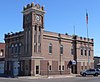 | September 3, 1981 (#81000370) | 1020 A St. 41°26′50″N 97°03′29″W / 41.447222°N 97.058056°W / 41.447222; -97.058056 (Schuyler City Hall) | Schuyler | |
| 8 | Schuyler Downtown Historic District |  | July 22, 2016 (#16000478) | Railside Dr., Colfax, 12th, C, D & 10th Sts. 41°26′50″N 97°03′27″W / 41.447329°N 97.057457°W / 41.447329; -97.057457 (Schuyler Downtown Historic District) | Schuyler | |
| 9 | Schuyler Site | Upload image | August 14, 1973 (#73001057) | Address Restricted | Schuyler | |
| 10 | US Post Office-Schuyler |  | May 11, 1992 (#92000476) | 119 E. 11th St. 41°26′50″N 97°03′32″W / 41.447117°N 97.058834°W / 41.447117; -97.058834 (US Post Office-Schuyler) | Schuyler | One of 12 Nebraska post offices featuring a Section of Fine Arts mural, "Wild Horses by Moonlight" (1940) by Philip von Saltza.[5] |
| 11 | Wolfe Archeological Site | Upload image | July 30, 1974 (#74001105) | Address Restricted | Schuyler | |
| 12 | Z.C.B.J. Opera House | 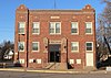 | September 28, 1988 (#88000948) | Fourth and Pine 41°43′26″N 97°07′21″W / 41.723889°N 97.1225°W / 41.723889; -97.1225 (Z.C.B.J. Opera House) | Clarkson | |
| 13 | Zion Presbyterian Church | 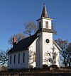 | January 7, 1988 (#87002071) | 5 miles southeast of Clarkson off Nebraska Highway 15 41°41′04″N 97°03′33″W / 41.684444°N 97.059167°W / 41.684444; -97.059167 (Zion Presbyterian Church) | Clarkson |
Former listings
| [3] | Name on the Register | Image | Date listed | Date removed | Location | City or town | Description |
|---|---|---|---|---|---|---|---|
| 1 | Our Lady of Perpetual Help Catholic Church & Cemetery |  | November 12, 1982 (#82000600) | June 26, 2023 | Southern side of Road N, 9 miles north and 5.5 miles west of Schuyler[6] 41°34′51″N 97°09′42″W / 41.580750°N 97.161750°W / 41.580750; -97.161750 (Our Lady of Perpetual Help Catholic Church & Cemetery) | Schuyler |
See also
- List of National Historic Landmarks in Nebraska
- National Register of Historic Places listings in Nebraska
References
- ^ The latitude and longitude information provided in this table was derived originally from the National Register Information System, which has been found to be fairly accurate for about 99% of listings. Some locations in this table may have been corrected to current GPS standards.
- ^ National Park Service, United States Department of the Interior, "National Register of Historic Places: Weekly List Actions", retrieved September 13, 2024.
- ^ a b Numbers represent an alphabetical ordering by significant words. Various colorings, defined here, differentiate National Historic Landmarks and historic districts from other NRHP buildings, structures, sites or objects.
- ^ The eight-digit number below each date is the number assigned to each location in the National Register Information System database, which can be viewed by clicking the number.
- ^ Ahlgren, Carol (August 1991). "National Register of Historic Places Multiple Property Documentation Form: Nebraska Post Offices Which Contain Section Artwork (1938-1942)" (PDF). Archived from the original on May 13, 2013. Retrieved 2013-01-28.
{{cite web}}: CS1 maint: unfit URL (link) - ^ Location derived from its NRHP nomination form[usurped]; the NRIS lists the site as "Address Restricted"
External links
Wikimedia Commons has media related to National Register of Historic Places in Colfax County, Nebraska.
- Nebraska National Register Sites in Colfax County[usurped]–Nebraska State Historical Society
- v
- t
- e

- Adams
- Antelope
- Arthur
- Banner
- Blaine
- Boone
- Box Butte
- Boyd
- Brown
- Buffalo
- Burt
- Butler
- Cass
- Cedar
- Chase
- Cherry
- Cheyenne
- Clay
- Colfax
- Cuming
- Custer
- Dakota
- Dawes
- Dawson
- Deuel
- Dixon
- Dodge
- Douglas
- Dundy
- Fillmore
- Franklin
- Frontier
- Furnas
- Gage
- Garden
- Garfield
- Gosper
- Grant
- Greeley
- Hall
- Hamilton
- Harlan
- Hayes
- Hitchcock
- Holt
- Hooker
- Howard
- Jefferson
- Johnson
- Kearney
- Keith
- Keya Paha
- Kimball
- Knox
- Lancaster
- Lincoln
- Logan
- Loup
- Madison
- McPherson
- Merrick
- Morrill
- Nance
- Nemaha
- Nuckolls
- Otoe
- Pawnee
- Perkins
- Phelps
- Pierce
- Platte
- Polk
- Red Willow
- Richardson
- Rock
- Saline
- Sarpy
- Saunders
- Scotts Bluff
- Seward
- Sheridan
- Sherman
- Sioux
- Stanton
- Thayer
- Thomas
- Thurston
- Valley
- Washington
- Wayne
- Webster
- Wheeler
- York
- Bridges
- Historic districts
- Houses
- National Historic Landmarks
- Properties of religious function
- Railway stations
 Category
 List
List National Register of Historic Places Portal


