National Register of Historic Places listings in McCurtain County, Oklahoma

This is a list of the National Register of Historic Places listings in McCurtain County, Oklahoma.
This is intended to be a complete list of the properties and districts on the National Register of Historic Places in McCurtain County, Oklahoma, United States. The locations of National Register properties and districts for which the latitude and longitude coordinates are included below, may be seen in a map.[1]
There are 16 properties and districts listed on the National Register in the county, including 1 National Historic Landmark.
This National Park Service list is complete through NPS recent listings posted September 5, 2024.[2]
Map all coordinates using OpenStreetMap
Download coordinates as:
- KML
- GPX (all coordinates)
- GPX (primary coordinates)
- GPX (secondary coordinates)
Current listings
| [3] | Name on the Register[4] | Image | Date listed[5] | Location | City or town | Description |
|---|---|---|---|---|---|---|
| 1 | Barnes-Stevenson House | 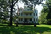 | November 17, 1978 (#78003083) | 3 Adams St., SE. 33°53′38″N 94°49′23″W / 33.893889°N 94.823056°W / 33.893889; -94.823056 (Barnes-Stevenson House) | Idabel | |
| 2 | Grobin Davis Mound Group | Upload image | November 23, 1984 (#84002637) | Address Restricted | Wright City | |
| 3 | Frisco Station | 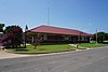 | May 21, 1979 (#79003137) | Texas Ave. 33°53′39″N 94°49′45″W / 33.894167°N 94.829167°W / 33.894167; -94.829167 (Frisco Station) | Idabel | |
| 4 | Jefferson Gardner House | Upload image | April 4, 1975 (#75002068) | 3 miles west of Eagletown off U.S. Route 70 34°02′47″N 94°37′24″W / 34.046389°N 94.623333°W / 34.046389; -94.623333 (Jefferson Gardner House) | Eagletown | |
| 5 | Garvin Rock Church | Upload image | June 16, 1980 (#80003275) | Love and Williams Sts. 33°57′19″N 94°56′25″W / 33.9552°N 94.9403°W / 33.9552; -94.9403 (Garvin Rock Church) | Garvin | Destroyed |
| 6 | Harkey Site | Upload image | December 19, 1978 (#78003084) | Address Restricted | Idabel | |
| 7 | Harris House | Upload image | September 1, 1978 (#78003082) | 6 miles (9.6 km.) south of Haworth 33°46′06″N 94°41′00″W / 33.768333°N 94.683333°W / 33.768333; -94.683333 (Harris House) | Haworth | |
| 8 | Idabel Armory | 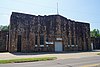 | September 8, 1988 (#88001409) | Washington St. and SE. Ave. F 33°53′43″N 94°49′16″W / 33.895278°N 94.821111°W / 33.895278; -94.821111 (Idabel Armory) | Idabel | |
| 9 | Pine Creek Mound Group | Upload image | January 21, 1974 (#74002194) | Address Restricted | Bethel | |
| 10 | Rouleau Hotel | 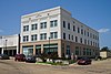 | September 14, 2002 (#02000974) | 20 E. Main St. 33°53′44″N 94°49′37″W / 33.895556°N 94.826944°W / 33.895556; -94.826944 (Rouleau Hotel) | Idabel | |
| 11 | Spaulding-Olive House |  | September 28, 1979 (#79003138) | 601 Adams, SE. 33°53′39″N 94°49′09″W / 33.894167°N 94.819167°W / 33.894167; -94.819167 (Spaulding-Olive House) | Idabel | |
| 12 | Tiner School | Upload image | November 21, 1980 (#80003274) | East of Broken Bow 34°02′24″N 94°38′03″W / 34.04°N 94.634167°W / 34.04; -94.634167 (Tiner School) | Broken Bow | |
| 13 | Valliant School Gymnasium-Auditorium | Upload image | September 8, 1988 (#88001410) | Wilbor and Lucas Sts. 34°00′15″N 95°05′16″W / 34.004167°N 95.087778°W / 34.004167; -95.087778 (Valliant School Gymnasium-Auditorium) | Valliant | |
| 14 | Waterhole Cemetery | Upload image | December 11, 1979 (#79002001) | South of Garvin 33°59′25″N 94°59′24″W / 33.990278°N 94.99°W / 33.990278; -94.99 (Waterhole Cemetery) | Garvin | |
| 15 | Wheelock Academy | Upload image | October 15, 1966 (#66000949) | East of Millerton on U.S. Route 70 33°59′38″N 94°59′18″W / 33.993889°N 94.988333°W / 33.993889; -94.988333 (Wheelock Academy) | Millerton | |
| 16 | Wheelock Church | Upload image | November 9, 1972 (#72001464) | 2 miles northeast of Millerton 33°59′26″N 94°59′25″W / 33.990556°N 94.990278°W / 33.990556; -94.990278 (Wheelock Church) | Millerton |
See also
Wikimedia Commons has media related to National Register of Historic Places in McCurtain County, Oklahoma.
- List of National Historic Landmarks in Oklahoma
- National Register of Historic Places listings in Oklahoma
References
- ^ The latitude and longitude information provided in this table was derived originally from the National Register Information System, which has been found to be fairly accurate for about 99% of listings. Some locations in this table may have been corrected to current GPS standards.
- ^ National Park Service, United States Department of the Interior, "National Register of Historic Places: Weekly List Actions", retrieved September 5, 2024.
- ^ Numbers represent an alphabetical ordering by significant words. Various colorings, defined here, differentiate National Historic Landmarks and historic districts from other NRHP buildings, structures, sites or objects.
- ^ "National Register Information System". National Register of Historic Places. National Park Service. March 13, 2009.
- ^ The eight-digit number below each date is the number assigned to each location in the National Register Information System database, which can be viewed by clicking the number.
- v
- t
- e
- Pine Creek Mound Group

- Tiner School
- Jefferson Gardner House
- Garvin Rock Church
- Waterhole Cemetery
- Harris House
- Barnes-Steverson House
- Idabel station
- Harkey Site
- Idabel Armory
- Rouleau Hotel
- Spaulding-Olive House
- Valliant School Gymnasium-Auditorium
See also: National Register of Historic Places listings in McCurtain County, Oklahoma and List of National Historic Landmarks in Oklahoma
| |
|---|---|
| Topics | |
| Lists by state |
|
| Lists by insular areas | |
| Lists by associated state | |
| Other areas | |
| Related | |
| |


Municipalities and communities of McCurtain County, Oklahoma, United States | ||
|---|---|---|
County seat: Idabel | ||
| Cities |  | |
| Towns | ||
| CDPs | ||
| Other communities | ||
| Ghost towns | ||
| Indian reservation | ||
| Footnotes | ‡This populated place also has portions in another county or counties | |
| ||


