National Register of Historic Places listings in Delaware County, Oklahoma

This is a list of the National Register of Historic Places listings in Delaware County, Oklahoma.
This is intended to be a complete list of the properties on the National Register of Historic Places in Delaware County, Oklahoma, United States. The locations of National Register properties for which the latitude and longitude coordinates are included below, may be seen in a map.[1]
There are 8 properties listed on the National Register in the county.
This National Park Service list is complete through NPS recent listings posted September 5, 2024.[2]
Map all coordinates using OpenStreetMap
Download coordinates as:
- KML
- GPX (all coordinates)
- GPX (primary coordinates)
- GPX (secondary coordinates)
Current listings
| [3] | Name on the Register[4] | Image | Date listed[5] | Location | City or town | Description |
|---|---|---|---|---|---|---|
| 1 | Bassett Grove Ceremonial Grounds | Upload image | July 20, 1983 (#83002085) | Address Restricted | Grove | |
| 2 | Beattie's Prairie | Upload image | March 11, 2014 (#14000050) | Address Restricted | Jay | |
| 3 | Corey House/Hotel | 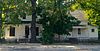 | December 17, 1982 (#82001495) | N. Main at 2nd St. 36°35′39″N 94°46′09″W / 36.594167°N 94.769167°W / 36.594167; -94.769167 (Corey House/Hotel) | Grove | |
| 4 | Delaware School, District No. 64 | Upload image | December 27, 2023 (#100009663) | approx. 6 miles (9.7 km) north of Jay on US 59/OK 10 36°30′10″N 94°46′52″W / 36.5029°N 94.7812°W / 36.5029; -94.7812 (Delaware School, District No. 64) | Jay | |
| 5 | Hildebrand Mill |  | October 18, 1972 (#72001062) | South of Colcord, 10 miles west of West Siloam Springs, Oklahoma 36°11′53″N 94°40′16″W / 36.198056°N 94.671111°W / 36.198056; -94.671111 (Hildebrand Mill) | Dripping Springs | |
| 6 | Polson Cemetery |  | November 21, 1977 (#77001092) | Northeast of Jay 36°31′31″N 94°38′10″W / 36.525278°N 94.636111°W / 36.525278; -94.636111 (Polson Cemetery) | Jay | |
| 7 | Saline District Courthouse | 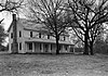 | January 1, 1976 (#76001561) | 1.5 miles south of the intersection of State Highway 33, Scenic U.S. Route 412, and County Road NS449 36°12′27″N 95°00′36″W / 36.2075°N 95.01°W / 36.2075; -95.01 (Saline District Courthouse) | Rose | |
| 8 | Splitlog Church |  | October 26, 1972 (#72001061) | About 9 miles northeast of Grove 36°38′01″N 94°40′47″W / 36.6335°N 94.6797°W / 36.6335; -94.6797 (Splitlog Church) | Grove |
See also
Wikimedia Commons has media related to National Register of Historic Places in Delaware County, Oklahoma.
- List of National Historic Landmarks in Oklahoma
- National Register of Historic Places listings in Oklahoma
References
- ^ The latitude and longitude information provided in this table was derived originally from the National Register Information System, which has been found to be fairly accurate for about 99% of listings. Some locations in this table may have been corrected to current GPS standards.
- ^ National Park Service, United States Department of the Interior, "National Register of Historic Places: Weekly List Actions", retrieved September 5, 2024.
- ^ Numbers represent an alphabetical ordering by significant words. Various colorings, defined here, differentiate National Historic Landmarks and historic districts from other NRHP buildings, structures, sites or objects.
- ^ "National Register Information System". National Register of Historic Places. National Park Service. March 13, 2009.
- ^ The eight-digit number below each date is the number assigned to each location in the National Register Information System database, which can be viewed by clicking the number.
- v
- t
- e

- Bassett Grove Ceremonial Grounds
- Corey House/Hotel
- Splitlog Church
- Beattie's Prairie
- Polson Cemetery
- Saline Courthouse
See also: National Register of Historic Places listings in Delaware County, Oklahoma and List of National Historic Landmarks in Oklahoma
| |
|---|---|
| Topics | |
| Lists by state |
|
| Lists by insular areas | |
| Lists by associated state | |
| Other areas | |
| Related | |
| |


Municipalities and communities of Delaware County, Oklahoma, United States | ||
|---|---|---|
County seat: Jay | ||
| Cities |  | |
| Towns | ||
| CDPs | ||
| Other communities | ||
| Indian reservation | ||
| Footnotes | ‡This populated place also has portions in an adjacent county or counties | |
| ||


