McLennan Hills
Volcano in New Zealand
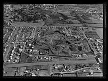
McLennan Hills (also Te Aponga o Tainui) is one of the volcanoes in the Auckland volcanic field. It was a group of cratered scoria mounds up to 45 m high, before it was quarried away. A 1940 aerial photo (in Searle's book) shows a crater around 100 m wide, one around 50 m wide, and 2 or 3 smaller craters. McLennan Hills, alongside neighbouring Ōtāhuhu / Mount Richmond, were the sites of fortified pā in pre-European times, important due to their location between the Waitematā Harbour/Tāmaki River and the Manukau Harbour.[1] Since the European settlement of Auckland, the scoria cone was quarried.[1] The former quarry site was used for greenhouses before being redeveloped for housing.
References
- City of Volcanoes: A geology of Auckland - Searle, Ernest J.; revised by Mayhill, R.D.; Longman Paul, 1981. First published 1964. ISBN 0-582-71784-1.
- Volcanoes of Auckland: A Field Guide. Hayward, B.W.; Auckland University Press, 2019, 335 pp. ISBN 0-582-71784-1.
References
- ^ a b Furey, Louise (1986). "The Excavation of Westfield (R11/898), South Auckland". Records of the Auckland Institute and Museum. 23: 1–24. ISSN 0067-0464. JSTOR 42906356. Wikidata Q58677261.
External links
- View south from Mt Wellington in 1920, showing McLennan Hills in distance.
- 1940s aerial photo of Mclennan Hills.
- Painting of McLennan Hills from the tuff ring crest of Mt Richmond in 1861.
36°55′45″S 174°50′47″E / 36.929208°S 174.846468°E / -36.929208; 174.846468
- v
- t
- e
Auckland volcanic field
- Pukekawa Volcano (10)
- Grafton Volcano (50)
- Albert Park Volcano (9)
- Te Pou Hawaiki (12)
- Maungawhau / Mount Eden (11)
- Ōhinerau / Mount Hobson (18)
- Mount Saint John (17)
- Maungakiekie / One Tree Hill (16)
- Te Tātua a Riukiuta (15)
- Ōwairaka / Mount Albert (13)
- Te Hopua a Rangi (27)
- Mount Smart (26)
- Ōrākei Basin (20)
- Puketāpapa (14)
- Little Rangitoto (19)

- Maungarei (24)
- Purchas Hill (23)
- Whakamuhu / Glover Park (21)
- Taylors Hill (22)
- Panmure Basin (25)
- Pigeon Mountain (36)
- Hampton Park (32)
- Ōtara Hill (33)
- Green Hill (34)
- Styaks Swamp (35)
- Pukewairiki (31)
- McLennan Hills (29)
- Ōtāhuhu / Mount Richmond (28)
- Robertson Hill (30)
- Ash Hill (49)
- Boggust Park Crater (51)
- Cemetery Crater (52)
- Crater Hill (45)
- Kohuora (46)
- Māngere Lagoon (38)
- Matukutūreia (47)
- Matukutūruru (48)
- Maungataketake (43)
- Waitomokia (40)
- Ōtuataua (42)
- Puhinui Craters (53)
- Pukeiti (41)
- Puketutu Island (39)
- Māngere Mountain (37)
- Pukaki Lagoon (44)
and North Shore
- Maungauika (6)
- Motukorea (8)
- Pupuke Moana / Pupuke Volcano (1)
- Rangitoto (7)
- Mount Cambria (5)
- Mount Victoria (4)
- Tank Farm (2)
- Onepoto (3)
 | This Auckland Region-related geography article is a stub. You can help Wikipedia by expanding it. |
- v
- t
- e


