Llallagua
You can help expand this article with text translated from the corresponding article in German. (February 2010) Click [show] for important translation instructions.
- View a machine-translated version of the German article.
- Machine translation, like DeepL or Google Translate, is a useful starting point for translations, but translators must revise errors as necessary and confirm that the translation is accurate, rather than simply copy-pasting machine-translated text into the English Wikipedia.
- Do not translate text that appears unreliable or low-quality. If possible, verify the text with references provided in the foreign-language article.
- You must provide copyright attribution in the edit summary accompanying your translation by providing an interlanguage link to the source of your translation. A model attribution edit summary is
Content in this edit is translated from the existing German Wikipedia article at [[:de:Llallagua]]; see its history for attribution. - You may also add the template
{{Translated|de|Llallagua}}to the talk page. - For more guidance, see Wikipedia:Translation.
Town in Potosí Department, Bolivia
Llallagua Llallawa | |
|---|---|
Town | |
 | |
 Seal | |
| 18°25′S 66°35′W / 18.417°S 66.583°W / -18.417; -66.583 | |
| Country |  Bolivia Bolivia |
| Department | Potosí Department |
| Province | Rafael Bustillo Province |
| Municipality | Llallagua Municipality |
| Canton | Llallagua Canton |
| Government | |
| • Mayor | Tomás Quiróz (Without Fear Movement; elected 2010) |
| • President | Maximo Urquieta Mitma (2007) |
| Elevation | 12,779 ft (3,895 m) |
| Population (2001) | |
| • Total | 20,065 |
| Time zone | UTC-4 (BOT) |
Llallagua (in hispanicized spelling) or Llallawa (Aymara for a monstrous potato (like two potatoes) or animal, Quechua for the god of seed-time during the Inca period)[1][2] is a town in the Potosí Department in Bolivia. It is the seat of the Llallagua Municipality, the third municipal section of the Rafael Bustillo Province.
Geography
Llallagua features a rare microclimate amidst the semi-arid tundras of Potosí and Oruro, due to its extreme elevation near 4000m. Semi-arid and with average temperatures in its warmest month sitting right on the 11 °C threshold, the city's climate straddles that of the subtropical highland climate (Cwc, according to the Köppen climate classification), with subpolar oceanic characteristics and a cold semi-arid climate (BSk). Summers are cool and wet with daily highs rarely rising above 22 °C, while winters feature cooler days with much colder nights averaging −4 °C. These low temperatures are a result of the extreme precipitation deficit during the winter months with the resulting aridity leading to an increased diurnal temperature variation.
Climate
| Climate data for Llallagua, elevation 3,800 m (12,500 ft) | |||||||||||||
|---|---|---|---|---|---|---|---|---|---|---|---|---|---|
| Month | Jan | Feb | Mar | Apr | May | Jun | Jul | Aug | Sep | Oct | Nov | Dec | Year |
| Record high °C (°F) | 26.2 (79.2) | 25.0 (77.0) | 23.5 (74.3) | 23.0 (73.4) | 24.0 (75.2) | 21.8 (71.2) | 21.0 (69.8) | 22.0 (71.6) | 23.5 (74.3) | 25.5 (77.9) | 24.5 (76.1) | 24.1 (75.4) | 26.2 (79.2) |
| Mean daily maximum °C (°F) | 17.0 (62.6) | 17.3 (63.1) | 17.6 (63.7) | 18.2 (64.8) | 16.9 (62.4) | 16.6 (61.9) | 15.4 (59.7) | 17.2 (63.0) | 18.1 (64.6) | 19.4 (66.9) | 20.1 (68.2) | 19.1 (66.4) | 17.7 (63.9) |
| Daily mean °C (°F) | 11.8 (53.2) | 11.8 (53.2) | 11.5 (52.7) | 10.8 (51.4) | 8.5 (47.3) | 7.6 (45.7) | 7.2 (45.0) | 8.5 (47.3) | 10.3 (50.5) | 11.9 (53.4) | 12.8 (55.0) | 12.8 (55.0) | 10.5 (50.8) |
| Mean daily minimum °C (°F) | 6.6 (43.9) | 6.4 (43.5) | 5.4 (41.7) | 3.3 (37.9) | 0.1 (32.2) | −1.3 (29.7) | −1.0 (30.2) | −0.2 (31.6) | 2.6 (36.7) | 4.5 (40.1) | 5.6 (42.1) | 6.6 (43.9) | 3.2 (37.8) |
| Record low °C (°F) | 2.2 (36.0) | 3.0 (37.4) | 1.0 (33.8) | −2.0 (28.4) | −5.0 (23.0) | −8.4 (16.9) | −6.0 (21.2) | −5.2 (22.6) | −2.6 (27.3) | 0.0 (32.0) | 2.0 (35.6) | 2.5 (36.5) | −8.4 (16.9) |
| Average precipitation mm (inches) | 170.1 (6.70) | 105.1 (4.14) | 86.4 (3.40) | 22.6 (0.89) | 2.8 (0.11) | 0.0 (0.0) | 5.7 (0.22) | 4.1 (0.16) | 13.3 (0.52) | 25.5 (1.00) | 43.8 (1.72) | 95.5 (3.76) | 574.9 (22.62) |
| Average precipitation days | 20.2 | 15.5 | 13.0 | 5.0 | 0.9 | 0.0 | 1.9 | 1.8 | 3.1 | 5.2 | 8.0 | 14.8 | 89.4 |
| Source: Servicio Nacional de Meteorología e Hidrología de Bolivia[3][4] | |||||||||||||
Gallery
-
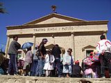 Simon I Patiño Theatre
 -
 Metavauxite, a rare member of the vauxite group. Siglo XX Mine, Llallagua, Bolivia. Size: 4.2 x 1.2 x 1.1 cm.


References
- ^ Radio San Gabriel, "Instituto Radiofonico de Promoción Aymara" (IRPA) 1993, Republicado por Instituto de las Lenguas y Literaturas Andinas-Amazónicas (ILLLA-A) 2011, Transcripción del Vocabulario de la Lengua Aymara, P. Ludovico Bertonio 1612 (Spanish-Aymara-Aymara-Spanish dictionary)
- ^ Teofilo Laime Ajacopa (2007). Diccionario Bilingüe: Iskay simipi yuyayk’anch: Quechua – Castellano / Castellano – Quechua (PDF). La Paz, Bolivia: futatraw.ourproject.org.
- ^ "Base de datos Sistema Meteorológico–SISMET" (in Spanish). Servicio Nacional de Meteorología e Hidrología de Bolivia. Archived from the original on 7 June 2018. Retrieved 12 June 2024.
- ^ "índices climáticos para 149 estaciones meteorológicas en Bolivia" (in Spanish). Servicio Nacional de Meteorología e Hidrología de Bolivia. Retrieved 12 June 2024.
- www.ine.gov.bo
External links
![]() Media related to Llallagua at Wikimedia Commons
Media related to Llallagua at Wikimedia Commons
- Map of the Rafael Bustillo Province
- v
- t
- e

Capital: Potosí

- Acasio (Acasio)
- Arampampa (Arampampa)
- Atocha (Atocha)
- Betanzos (Betanzos)
- Caiza "D" (Caiza "D")
- Ckochas (Ckochas)
- Caripuyo (Caripuyo)
- Chaquí (Chaquí)
- Chayanta (Chayanta)
- Chuquihuta (Chuquihuta)
- Colcha "K" (Colcha "K")
- Colquechaca (Colquechaca)
- Cotagaita (Cotagaita)
- Llallagua (Llallagua)
- Llica (Llica)
- Mojinete Municipality (Mojinete)
- Ocurí (Ocurí)
- Pocoata (Pocoata)
- Porco (Porco)
- Potosí (Potosí)
- Puna (Puna)
- Ravelo (Ravelo)
- Sacaca (Sacaca)
- San Agustín (San Agustín)
- San Antonio de Esmoruco (San Antonio de Esmoruco)
- San Pablo de Lípez (San Pablo de Lípez)
- San Pedro de Buena Vista (San Pedro de Buena Vista)
- San Pedro de Quemes (San Pedro de Quemes)
- Tacobamba (Tacobamba)
- Tahua (Tahua)
- Tinguipaya (Tinguipaya)
- Tomave (Tomave)
- Toro Toro (Toro Toro)
- Tupiza (Tupiza)
- Uncía (Uncía)
- Urmiri (Urmiri)
- Uyuni (Uyuni)
- Villazón (Villazón)
- Vitichi (Vitichi)
- Yocalla (Yocalla)
Authority control databases | |
|---|---|
| International |
|
| National |
|
This Potosí Department location article is a stub. You can help Wikipedia by expanding it. |
- v
- t
- e


