Atocha Municipality
You can help expand this article with text translated from the corresponding article in Spanish. (June 2011) Click [show] for important translation instructions.
- View a machine-translated version of the Spanish article.
- Machine translation, like DeepL or Google Translate, is a useful starting point for translations, but translators must revise errors as necessary and confirm that the translation is accurate, rather than simply copy-pasting machine-translated text into the English Wikipedia.
- Do not translate text that appears unreliable or low-quality. If possible, verify the text with references provided in the foreign-language article.
- You must provide copyright attribution in the edit summary accompanying your translation by providing an interlanguage link to the source of your translation. A model attribution edit summary is
Content in this edit is translated from the existing Spanish Wikipedia article at [[:es:Atocha (Potosí)]]; see its history for attribution. - You may also add the template
{{Translated|es|Atocha (Potosí)}}to the talk page. - For more guidance, see Wikipedia:Translation.
Municipality in Potosí Department, Bolivia

Flag

Location within Potosí Department
 Bolivia
 (2001)
Atocha Municipality is the second municipal section of the Sud Chichas Province in the Potosí Department in Bolivia. Its seat is Atocha. It is located within the Andes mountain range.
Subdivision
Atocha Municipality was created on September 21, 1963 by Law No. 245[1] consisting of the following seven cantons: Chocaya, Portugalete, San Vicente, Santa Bárbara, Tacmari, Guadalupe and Chorolque Viejo.
The National Institute of Statistics of Bolivia INE lists eight divisions of the municipality of Atocha:[2] Atocha, Chorolque, Chorolque Viejo, Portugalete, Chocaya, Guadalupe, San Vicente, Santa Bárbara.
The people
The people are predominantly indigenous citizens of Quechua descent.[3]
| Ethnic group | % |
|---|---|
| Quechua | 70.6 |
| Aymara | 2.8 |
| Guaraní, Chiquitos, Moxos | 0.2 |
| Not indigenous | 26.4 |
| Other indigenous groups | 0.1 |
Languages
The languages spoken in the municipality are mainly Spanish and Quechua .
| Language | Inhabitants |
|---|---|
| Quechua | 4,910 |
| Aymara | 274 |
| Guaraní | 11 |
| Another native | 1 |
| Spanish | 8,580 |
| Foreign | 26 |
| Only native | 395 |
| Native and Spanish | 4,602 |
| Only Spanish | 3,979 |
Ref: obd.descentralizacion.gov.bo
Places of interest
The colonial settlement Atocha Viejo ("Old Atocha") as well as the land relief are a tourist attraction.
-
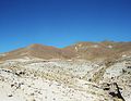
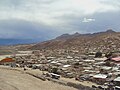 Atocha
 -
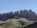 "The sails" (Las velas)
 -
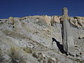 The egg and the bottle (El huevo y la botella)
 -
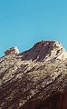
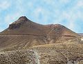 "Lion" (La leona), Chorolque
 -
 "Sleeping Beauty" (La Bella Durmiente)
 -
 "The camel" (El Camello)
 -
 El hielito


See also
- Kunturillu
- Santa Bárbara (Chorolque)
- Siete Suyos
- Wila Qullu
References
- ^ Law No. 245, Ley de 21 de septiembre de 1963 Archived March 26, 2012, at the Wayback Machine
- ^ INE, Bolivia, Division of Atocha Municipality: Population Data[permanent dead link]
- ^ obd.descentralizacion.gov.bo/municipal/fichas/ obd.descentralizacion.gov.bo
External links
Wikimedia Commons has media related to Atocha.
- Atocha Municipality: population data and map (PDF; 625 kB)
- v
- t
- e

Capital: Potosí

- Acasio (Acasio)
- Arampampa (Arampampa)
- Atocha (Atocha)
- Betanzos (Betanzos)
- Caiza "D" (Caiza "D")
- Ckochas (Ckochas)
- Caripuyo (Caripuyo)
- Chaquí (Chaquí)
- Chayanta (Chayanta)
- Chuquihuta (Chuquihuta)
- Colcha "K" (Colcha "K")
- Colquechaca (Colquechaca)
- Cotagaita (Cotagaita)
- Llallagua (Llallagua)
- Llica (Llica)
- Mojinete Municipality (Mojinete)
- Ocurí (Ocurí)
- Pocoata (Pocoata)
- Porco (Porco)
- Potosí (Potosí)
- Puna (Puna)
- Ravelo (Ravelo)
- Sacaca (Sacaca)
- San Agustín (San Agustín)
- San Antonio de Esmoruco (San Antonio de Esmoruco)
- San Pablo de Lípez (San Pablo de Lípez)
- San Pedro de Buena Vista (San Pedro de Buena Vista)
- San Pedro de Quemes (San Pedro de Quemes)
- Tacobamba (Tacobamba)
- Tahua (Tahua)
- Tinguipaya (Tinguipaya)
- Tomave (Tomave)
- Toro Toro (Toro Toro)
- Tupiza (Tupiza)
- Uncía (Uncía)
- Urmiri (Urmiri)
- Uyuni (Uyuni)
- Villazón (Villazón)
- Vitichi (Vitichi)
- Yocalla (Yocalla)


