List of national monuments in County Louth
Map all coordinates using OpenStreetMap
Download coordinates as:
- KML
- GPX (all coordinates)
- GPX (primary coordinates)
- GPX (secondary coordinates)
The Irish state has officially approved the following list of national monuments in County Louth. In the Republic of Ireland, a structure or site may be deemed to be a "national monument", and therefore worthy of state protection, if it is of national importance. If the land adjoining the monument is essential to protect it, this land may also be protected.
National Monuments
| NM# | Monument name | Description | Image | Townland | Location |
|---|---|---|---|---|---|
| 326 | Aghnaskeagh Cairns | Two Cairns |  | Aghnaskeagh | 54°03′39″N 6°21′28″W / 54.060871°N 6.357804°W / 54.060871; -6.357804 |
| LH018-040 | Athclare Castle | Castle |  | Athclare | 53°29′08″N 6°14′07″W / 53.4855°N 6.2353°W / 53.4855; -6.2353 |
| 480 | Mansfieldstown Church | Church |  | Bawn | 53°53′49″N 6°26′45″W / 53.896898°N 6.445724°W / 53.896898; -6.445724 |
| 249 | Carlingford Castle | Castle |  | Carlingford | 54°02′36″N 6°11′13″W / 54.043207°N 6.186884°W / 54.043207; -6.186884 |
| 242 | The Mint | Urban Tower House |  | Carlingford | 54°02′24″N 6°11′11″W / 54.040052°N 6.186259°W / 54.040052; -6.186259 |
| 388 | Dun Dealgan | Motte |  | Castletown | 54°00′50″N 6°25′49″W / 54.013836°N 6.430278°W / 54.013836; -6.430278 |
| 526 | Donaghmore Souterrain | Souterrain |  | Donaghmore | 54°00′11″N 6°27′36″W / 54.003072°N 6.460048°W / 54.003072; -6.460048 |
| 511 | St. Laurence's Gate | Town Gate |  | Drogheda | 53°46′31″N 7°30′01″W / 53.775218°N 7.500249°W / 53.775218; -7.500249 |
| 92 | Dromiskin | Church & Round Tower |  | Dromiskin | 53°55′20″N 6°23′54″W / 53.922124°N 6.398255°W / 53.922124; -6.398255 |
| 144 | Greenmount motte | Motte |  | Greenmount | 53°52′41″N 6°23′08″W / 53.8781°N 6.3856°W / 53.8781; -6.3856 |
| 623 | Carlingford Abbey | Friary (Dominican) |  | Carlingford | 54°02′17″N 6°11′04″W / 54.038139°N 6.18451°W / 54.038139; -6.18451 |
| 579 | Lisnaran Fort | Ringfort | Linns | 53°52′58″N 6°20′49″W / 53.882811°N 6.347015°W / 53.882811; -6.347015 | |
| 93 | Mellifont Abbey | Abbey (Cistercian) | 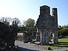 | Drogheda | 53°44′33″N 6°27′59″W / 53.74241°N 6.466337°W / 53.74241; -6.466337 |
| 94 | Monasterboice | High crosses, churches & round tower |  | Monasterboice | 53°46′39″N 6°25′05″W / 53.777518°N 6.41809°W / 53.777518; -6.41809 |
| 312 | St. Mochta's House | Church |  | Priorstate | 53°57′12″N 6°32′44″W / 53.953335°N 6.545541°W / 53.953335; -6.545541 |
| 476 | Proleek Dolmen | Portal Tomb & wedge Tomb |  | Proleek | 54°02′14″N 6°20′54″W / 54.037177°N 6.348344°W / 54.037177; -6.348344 |
| 474 | Clochafarmore | Standing Stone |  | Rathiddy | 53°58′28″N 6°27′57″W / 53.974507°N 6.465904°W / 53.974507; -6.465904 |
| 597 | Ravensdale Park | Cairn |  | Ravensdale Park | 54°04′45″N 6°19′18″W / 54.079257°N 6.321654°W / 54.079257; -6.321654 |
| 460 | Castleroche Castle | Castle | 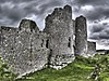 | Dundalk | 54°02′47″N 6°29′18″W / 54.046478°N 6.488439°W / 54.046478; -6.488439 |
| 562 | Rockmarshall Court Tomb | Court Tomb | Annaloughan | 54°00′33″N 6°17′05″W / 54.009167°N 6.284722°W / 54.009167; -6.284722 | |
| 298 | Roodstown Castle | Castle |  | Roodstown | 53°52′21″N 6°29′12″W / 53.872416°N 6.486669°W / 53.872416; -6.486669 |
| 178 | Termonfeckin Castle | Castle | 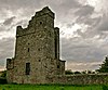 | Termonfeckin | 53°45′43″N 6°16′01″W / 53.76190°N 6.26697°W / 53.76190; -6.26697 |
| 529 | Townleyhall passage grave | Passage Tomb |  | Townleyhall | 53°43′16″N 6°27′05″W / 53.721150°N 6.451253°W / 53.721150; -6.451253 |
Sources
- National Monuments in County Louth


