List of national monuments in County Kildare
Map all coordinates using OpenStreetMap
Download coordinates as:
- KML
- GPX (all coordinates)
- GPX (primary coordinates)
- GPX (secondary coordinates)
The Irish state has officially approved the following list of national monuments in County Kildare. In the Republic of Ireland, a structure or site may be deemed to be a "national monument", and therefore worthy of state protection, if it is of national importance. If the land adjoining the monument is essential to protect it, this land may also be protected.
National Monuments
| NM# | Monument name | Description | Image | Townland | Location |
|---|---|---|---|---|---|
| 681 | Conolly's Folly | Folly/Obelisk |  | Barrogstown West | 53°22′10″N 6°33′36″W / 53.36943°N 6.55990°W / 53.36943; -6.55990 (Conolly's Folly) |
| 471 | Castledermot Round Tower | Round Tower & Crosses |  | Castledermot | 52°54′38″N 6°50′06″W / 52.910458°N 6.834934°W / 52.910458; -6.834934 |
| 200 | Castledermot Abbey | Friary (Franciscan) |  | Castledermot | 52°54′31″N 6°50′14″W / 52.908556°N 6.837141°W / 52.908556; -6.837141 |
| 394 | Furness Church | Church | Forenaghts Great | 53°13′25″N 6°36′09″W / 53.22367°N 6.60249°W / 53.22367; -6.60249 | |
| 629 | Grange Castle | Castle |  | Grange West | 53°22′30″N 7°04′05″W / 53.375118°N 7.068169°W / 53.375118; -7.068169 |
| 528 | Jigginstown House | House - 16th/17th Century |  | Jigginstown | 53°12′50″N 6°40′57″W / 53.213788°N 6.682488°W / 53.213788; -6.682488 |
| 275 | Kilteel Castle | Castle & Cross |  | Kilteel Upper | 53°13′57″N 6°31′39″W / 53.23263°N 6.52745°W / 53.23263; -6.52745 |
| 485 | Maynooth Castle | Castle |  | Maynooth | 53°22′51″N 6°35′40″W / 53.38079°N 6.5944°W / 53.38079; -6.5944 (Maynooth Castle) |
| 674 | Moone High Cross | High Cross | 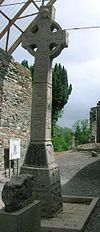 | Moone | 52°58′46″N 6°49′31″W / 52.979409257343704°N 6.825243914650416°W / 52.979409257343704; -6.825243914650416 |
| 589 | Mullaghreelan Rath | Ringfort | Mullaghreelan | 52°56′09″N 6°52′24″W / 52.935953°N 6.873419°W / 52.935953; -6.873419 | |
| 71 | Old Kilcullen | Church, Round Tower & Crosses |  | Old Kilcullen | 53°06′28″N 6°45′39″W / 53.10776°N 6.76080°W / 53.10776; -6.76080 (Old Kilcullen) |
| 190 | Oughter Ard Tower | Round Tower & Church |  | Oughter Ard | 53°16′40″N 6°33′57″W / 53.277716°N 6.565894°W / 53.277716; -6.565894 |
| 305 | Punchestown Longstone | Standing Stone |  | Punchestown Great | 53°11′31″N 6°37′42″W / 53.19184°N 6.62838°W / 53.19184; -6.62838 |
| 404 | Rathcoffey Castle | Castle gatehouse |  | Rathcoffey Demesne | 53°19′53″N 6°39′53″W / 53.33140°N 6.66472°W / 53.33140; -6.66472 |
| 503 | St John's Tower | Tower, formerly part of hospital | Skenagun | 52°54′50″N 6°50′16″W / 52.91399°N 6.83781°W / 52.91399; -6.83781 | |
| 70, 578 | Taghadoe | Round Tower and Church |  | Taghadoe | 53°21′12″N 6°36′48″W / 53.353199°N 6.613237°W / 53.353199; -6.613237 |
Sources
- National Monuments in County Kildare


