List of lighthouses in South Carolina
This is a list of lighthouses in South Carolina.
| Name | Image | Location | Coordinates | Year first lit | Automated | Year deactivated | Current Lens | Focal Height |
|---|---|---|---|---|---|---|---|---|
| Bloody Point Range Front Light | N/A | Daufuskie Island | N/A | 1883 | Never | 1922 (Preserved) | None | Unknown |
| Bloody Point Range Rear Light | N/A | Daufuskie Island | N/A | 1883 (First) 1899 (Last) | Never | 1922 (Removed) | None | 081 81 ft (25 m) (Original rear range) |
| Bulls Bay Light | N/A | Charleston County | N/A | 1852 (First) 1900 (Last) | Never | 1913 (Destroyed) | None | 044 44 ft (13 m) (First lighthouse) |
| Cape Romain Light (Old) |  | Cape Romain | 33°01′06.6″N 79°22′26.6″W / 33.018500°N 79.374056°W / 33.018500; -79.374056 | 1827 | Never | 1858 | None | 088 88 ft (27 m) |
| Cape Romain Light (New) |  | Cape Romain | 33°01′08″N 79°22′25″W / 33.01889°N 79.37361°W / 33.01889; -79.37361 | 1858 | 1937 | 1947 | None | 161 161 ft (49 m) |
| Castle Pinckney Light | Charleston County | 32°46′25.1″N 79°54′39.6″W / 32.773639°N 79.911000°W / 32.773639; -79.911000 | 1855 (First) 1890 (Last) | Never | 1917 (Destroyed by 1938) | None | 050 50 ft (15 m) | |
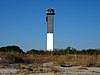
| Charleston Light |  | Sullivan's Island | 32°45′28.5″N 79°50′35.7″W / 32.757917°N 79.843250°W / 32.757917; -79.843250 | 1962 | 1975 | Active | DCB-24 | 163 163 ft (50 m) |
| Combahee Bank Light | N/A | Saint Helena Sound | 32°28′N 80°26′W / 32.467°N 80.433°W / 32.467; -80.433 | 1868 | Never | 1876 (Removed in 1925) | None | Unknown |
| Fort Ripley Shoal Light | Charleston | 32°45′58″N 79°54′07″W / 32.766°N 79.902°W / 32.766; -79.902 (Estimated) | 1878 | Never | 1932 (Dismantled) | None | Unknown | |
| Fort Sumter Range Front Light |  | Charleston | 32°45′8″N 79°52′29″W / 32.75222°N 79.87472°W / 32.75222; -79.87472 | 1855 (First) 1893 (Last) | Never | 1950s | None | Unknown |
| Fort Sumter Range Rear Light |  | Charleston | 32°45′8″N 79°52′29″W / 32.75222°N 79.87472°W / 32.75222; -79.87472 | 1855 (First) 1893 (Last) | Never | 1915 | None | 140 140 ft (43 m) |
| Georgetown Light |  | Winyah Bay | 33°13′21.47″N 79°11′6.18″W / 33.2226306°N 79.1850500°W / 33.2226306; -79.1850500 | 1801 (First) 1867 (Current) | 1986 | Active | VRB-25 | 085 85 ft (26 m) |
| Governor's LightA | N/A | Little River | N/A | 1985[1] (Private) | Always | Active | Unknown | 060 60 ft (18 m)[1] |
| Haig Point Front Range Light |  | Daufuskie Island | N/A | 1873[2] | Never | DisputedB (Removed) | None | 017 17 ft (5.2 m)[2] |
| Haig Point Rear Range Light |  | Daufuskie Island | N/A | 1873 | 1987 (Relit) | Active (Inactive: ????-1987B) | Acrylic | 070 70 ft (21 m) |
| Harbour Town Light |  | Hilton Head Island | 32°08′19″N 80°48′46″W / 32.13861°N 80.81278°W / 32.13861; -80.81278 | 1970 | Always | Active | Unknown | 090 90 ft (27 m) |
| Hilton Head Range Front Light | N/A | Hilton Head Island | N/A | 1881 | Never | 1932 (Destroyed) | None | 035 35 ft (11 m) |
| Hilton Head Range Rear Light |  | Hilton Head Island | 32°9′51″N 80°44′24″W / 32.16417°N 80.74000°W / 32.16417; -80.74000 | 1880 | Never | 1932 | None | 092 92 ft (28 m) |
| Hunting Island Light |  | Beaufort (Hunting Island State Park) | 32°22′32″N 80°26′15″W / 32.37556°N 80.43750°W / 32.37556; -80.43750 | 1859 (First) 1875 (Current) | 1995 (Relit) | Active (Inactive: 1933-1995 | Unknown | 132 132 ft (40 m) |
| Morris Island Range Front LightC | N/A | Morris Island | N/A | 1871[3] | Never | UnknownD (Removed) | None | Unknown |
| Morris Island Range Rear LightC | N/A | Morris Island | N/A | 1871[3] | Never | UnknownD (Removed) | None | Unknown |
| Morris Island Light |  | Morris Island | 32°41′43″N 79°53′1″W / 32.69528°N 79.88361°W / 32.69528; -79.88361 | 1767[3] (First) 1876[3] (Current) | 1938[3] | 1962[3] | None | Unknown |
| Parris Island Range Front Light | N/A | Parris Island | N/A | 1881 | Never | 1923 | None | Unknown |
| Parris Island Range Rear Light | N/A | Parris Island | 32°18′46″N 80°40′39″W / 32.31278°N 80.67750°W / 32.31278; -80.67750 | 1881 | Never | 1923 | None | 120 120 ft (37 m) |
| Sullivan's Island Range Front Light |  | Sullivan's Island | N/A | 1848 (First) 1872 (Last) | Never | Unknown (Removed) | None | Unknown |
| Sullivan's Island Range Rear Light | N/A | Sullivan's Island | N/A | 1848 (First) 1872 (Last) | Never | Unknown (Removed) | None | 120 120 ft (37 m) |
Notes
- A.^ This lighthouse was built in honor of South Carolina's governors. It is privately maintained and an unofficial aid to navigation.
- B.^ The deactivation date for the Haig Point Range Lights is disputed among sources. Click on the article for more information.
- C.^ Not much is known about this set of range lights. The two structures were built in 1871 after the second Morris Island lighthouse was destroyed in the civil war, as navigation was needed in the area.
- D.^ Listed on the light list as late as 1898.[1]
References
- ^ a b c Rowlett, Russ. "Lighthouses of the United States: South Carolina". The Lighthouse Directory. University of North Carolina at Chapel Hill. Retrieved October 15, 2017.
- ^ a b "Name: Haig Point Front Range Light". Lighthouse Digest. Retrieved October 15, 2017.
- ^ a b c d e f "Morris Island Lighthouse". Lighthouse Friends. Retrieved October 15, 2017.
- v
- t
- e
- Alabama
- Alaska
- California
- Connecticut
- Delaware
- Florida
- Georgia
- Hawaii
- Illinois and Indiana
- Louisiana
- Maine
- Maryland
- Massachusetts
- Michigan
- Minnesota
- Mississippi
- Nebraska
- New Hampshire
- New Jersey
- New York
- North Carolina
- Ohio
- Oregon
- Pennsylvania
- Rhode Island
- South Carolina
- Texas
- Vermont
- Virginia
- Washington
- Wisconsin


 List_of_lighthouses_in_South_Carolina