Woughton
| Woughton | |||
|---|---|---|---|
 | |||
| Land |  Storbritannia Storbritannia | ||
| Konst. land |  England England | ||
| Distrikt | Milton Keynes | ||
| Admin. grevskap | Enhetlig myndighet | ||
| Seremon. grevskap | Buckinghamshire | ||
| Status | Landsby (village) | ||
| Postnummer | MK6 | ||
| Retningsnummer | 01908 | ||
| Befolkning | 13 422[1] (2021) | ||
 Woughton on the Green 52°01′36″N 0°44′22″V | |||
Woughton på Commons | |||
Woughton (lokal uttale ˈwʌftən) er et verdslig sogn i Milton Keynes i England. Det ligger sør innenfor byområdet, sør for sentrum, og har navn etter landsbyen Woughton on the Green.
Sognet er avgrenset av A5 i vest, elven Ouzel i øst, Chaffron Way (H9) i nord og Groveway (H9) i sør. Det består av flere distrikter:
- Beanhill
- Bleak Hall
- Coffee Hall
- Eaglestone (med Milton Keynes General Hospital)
- Leadenhall (med Milton Keynes College)
- Netherfield
- Peartree Bridge
- Redmoor
- Tinkers Bridge
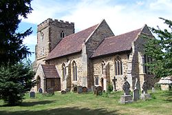
- Woughton on the Green
- Woughton Park
- v
- d
- r
Verdslige sogn i distriktet Milton Keynes
- Astwood
- Bletchley and Fenny Stratford
- Bow Brickhill
- Bradwell
- Bradwell Abbey
- Broughton
- Calverton
- Campbell Park
- Castlethorpe
- Central Milton Keynes
- Chicheley
- Clifton Reynes
- Cold Brayfield
- Emberton
- Gayhurst
- Great Linford
- Hanslope
- Hardmead
- Haversham med Little Linford
- Kents Hill, Monkston and Brinklow
- Lathbury
- Lavendon
- Little Brickhill
- Loughton
- Middleton
- Moulsoe
- New Bradwell
- Newport Pagnell
- Newton Blossomville
- North Crawley
- Olney
- Ravenstone
- Shenley Brook End
- Shenley Church End
- Sherington
- Simpson
- Stantonbury
- Stoke Goldington
- Stony Stratford
- Tyringham and Filgrave
- Walton
- Warrington
- Wavendon
- West Bletchley
- Weston Underwood
- Woburn Sands
- Wolverton and Greenleys
- Woughton
- ^ "Parish Profiles"; besøksdato: 5. august 2024; utgiver: Office for National Statistics; publisert i: folketelling i Storbritannia 2021.


