Comanche County (Oklahoma)
County in de Verenigde Staten  | |||
|---|---|---|---|
 | |||
| Situering | |||
| Staat | Oklahoma | ||
| Tijdzone | Central Standard Time (UTC−6) | ||
| Coördinaten | 34°39'36"NB, 98°27'36"WL | ||
| Algemeen | |||
| Oppervlakte | 2.808 km² | ||
| - land | 2.770 km² | ||
| - water | 38 km² | ||
| Inwoners (2000) | 114.996 (42 inw./km²) | ||
| Overig | |||
| Zetel | Lawton | ||
| FIPS-code | 40031 | ||
| Opgericht | 1901 | ||
| Website | Officiële website | ||
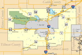
| Detailkaart | |||
 | |||
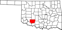
| Overzichtskaart van Comanche County | |||
| Foto's | |||
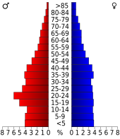 Bevolkingspiramide Comanche County | |||
| Statistieken volkstelling Comanche County | |||
| |||

Comanche County is een van de 77 county's in de Amerikaanse staat Oklahoma.
De county heeft een landoppervlakte van 2.770 km² en telt 114.996 inwoners (volkstelling 2000). De hoofdplaats is Lawton.
In de county ligt de berg Mount Scott.
Adair County · Alfalfa County · Atoka County · Beaver County · Beckham County · Blaine County · Bryan County · Caddo County · Canadian County · Carter County · Cherokee County · Choctaw County · Cimarron County · Cleveland County · Coal County · Comanche County · Cotton County · Craig County · Creek County · Custer County · Delaware County · Dewey County · Ellis County · Garfield County · Garvin County · Grady County · Grant County · Greer County · Harmon County · Harper County · Haskell County · Hughes County · Jackson County · Jefferson County · Johnston County · Kay County · Kingfisher County · Kiowa County · Latimer County · Le Flore County · Lincoln County · Logan County · Love County · Major County · Marshall County · Mayes County · McClain County · McCurtain County · McIntosh County · Murray County · Muskogee County · Noble County · Nowata County · Okfuskee County · Oklahoma County · Okmulgee County · Osage County · Ottawa County · Pawnee County · Payne County · Pittsburg County · Pontotoc County · Pottawatomie County · Pushmataha County · Roger Mills County · Rogers County · Seminole County · Sequoyah County · Stephens County · Texas County · Tillman County · Tulsa County · Wagoner County · Washington County · Washita County · Woods County · Woodward County
Mediabestanden
Zie de categorie Comanche County, Oklahoma van Wikimedia Commons voor mediabestanden over dit onderwerp.


