Étrepigney
Gemeente in Frankrijk  | |||
|---|---|---|---|
 | |||
  | |||
| Situering | |||
| Regio | Bourgogne-Franche-Comté | ||
| Departement | Jura (39) | ||
| Arrondissement | Dole | ||
| Kanton | Mont-sous-Vaudrey | ||
| Coördinaten | 47° 8′ NB, 5° 42′ OL | ||
| Algemeen | |||
| Oppervlakte | 15,6 km² | ||
| Inwoners (1 januari 2021) | 432[1] (28 inw./km²) | ||
| Hoogte | 207 - 262 m | ||
| Overig | |||
| Postcode | 39700 | ||
| INSEE-code | 39218 | ||
| Website | Officiële website | ||
| |||

Étrepigney is een gemeente in het Franse departement Jura (regio Bourgogne-Franche-Comté) en telt 357 inwoners (1999). De plaats maakt deel uit van het arrondissement Dole.
Geografie
De oppervlakte van Étrepigney bedraagt 15,3 km², de bevolkingsdichtheid is 23,3 inwoners per km².
De onderstaande kaart toont de ligging van Étrepigney met de belangrijkste infrastructuur en aangrenzende gemeenten.
 |
Demografie
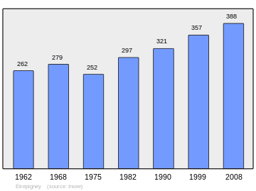
Onderstaande figuur toont het verloop van het inwonertal (bron: INSEE-tellingen).
Externe links
- (fr) Statistische informatie op de website van INSEE
Mediabestanden
Zie de categorie Étrepigney van Wikimedia Commons voor mediabestanden over dit onderwerp.
- ↑ Populations légales 2021.


