Leatherhead
 Disambiguazione – Se stai cercando altri significati, vedi Leatherhead (disambigua).
Questa voce sull'argomento centri abitati del Surrey è solo un abbozzo.
Contribuisci a migliorarla secondo le convenzioni di Wikipedia.
| Leatherhead parrocchia civile | |
|---|---|
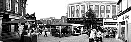 | |
| Localizzazione | |
| Stato |  Regno Unito Regno Unito Inghilterra Inghilterra |
| Regione | Sud Est |
| Contea |  Surrey Surrey |
| Distretto | Mole Valley |
| Territorio | |
| Coordinate | 51°17′N 0°19′W51°17′N, 0°19′W (Leatherhead) |
| Superficie | 12,54 km² |
| Abitanti | 9 685 (2001) |
| Densità | 772,33 ab./km² |
| Altre informazioni | |
| Cod. postale | KT22 |
| Prefisso | 01372 |
| Fuso orario | UTC+0 |
| Cartografia | |
  Leatherhead | |
| Sito istituzionale | |
| Modifica dati su Wikidata · Manuale | |
Leatherhead è un paese di 9.685 abitanti della contea del Surrey, in Inghilterra.
Altri progetti
Altri progetti
- Wikimedia Commons
 Wikimedia Commons contiene immagini o altri file su Leatherhead
Collegamenti esterni
- Sito ufficiale, su molevalley.gov.uk.


V · D · M | |
|---|---|
| Distretti o Borough | Elmbridge · Epsom and Ewell · Guildford · Mole Valley · Reigate and Banstead · Runnymede · Spelthorne · Surrey Heath · Tandridge · Waverley · Woking |
| Città e paesi | Addlestone · Ashford · Banstead · Brookwood · Camberley · Caterham · Chertsey · Cobham · Dorking · Earlswood · Egham · Egham Hythe · Englefield Green · Epsom · Esher · Ewell · Farleigh · Farnham · Godalming · Guildford · Haslemere · Horley · Hurst Green · Leatherhead · Oxted · Redhill · Reigate · Shepperton · Staines-upon-Thames · Sunbury-on-Thames · Virginia Water · Walton-on-Thames · Weybridge · Whyteleafe · Woking Parrocchie civili del Surrey |
| Controllo di autorità | VIAF (EN) 132456538 · LCCN (EN) n87859439 · GND (DE) 4594090-3 · J9U (EN, HE) 987007560138005171 |
|---|
 Portale Regno Unito: accedi alle voci di Wikipedia che parlano del Regno Unito


