Brasted

Questa voce sull'argomento centri abitati del Kent è solo un abbozzo.
Contribuisci a migliorarla secondo le convenzioni di Wikipedia.
| Brasted parrocchia civile | |
|---|---|
 | |
| Localizzazione | |
| Stato |  Regno Unito Regno Unito Inghilterra Inghilterra |
| Regione | Sud Est |
| Contea |  Kent Kent |
| Distretto | Sevenoaks |
| Territorio | |
| Coordinate | 51°16′35.8″N 0°06′38.84″E51°16′35.8″N, 0°06′38.84″E (Brasted) |
| Abitanti | 1 429 (2011) |
| Altre informazioni | |
| Prefisso | 01959 |
| Fuso orario | UTC+0 |
| Cartografia | |
  Brasted | |
| Modifica dati su Wikidata · Manuale | |
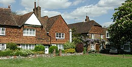
Brasted è un villaggio e parrocchia civile dell'Inghilterra, appartenente alla contea del Kent.
Altri progetti
Altri progetti
- Wikimedia Commons
 Wikimedia Commons contiene immagini o altri file su Brasted
Collegamenti esterni
- (EN) Sito web del Kent, su kent.gov.uk.
V · D · M | |
|---|---|
| Ash · Badgers Mount · Bough Beech · Brasted · Brasted Chart · Chartwell · Chevening · Chiddingstone · Chiddingstone Causeway · Chiddingstone Hoath · Chipstead · Cowden · Crockenhill · Crockham Hill · Dunton Green · Edenbridge · Eynsford · Farningham · Fawkham · Fawkham Green · Fordcombe · Four Elms · Godden Green · Halstead · Hartley · Hever · Hextable · Hodsoll Street · Horton Kirby · Ide Hill · Kemsing · Knockholt · Leigh · Markbeech · New Ash Green · Otford · Penshurst · Ridley · Riverhead · Seal · Seal Chart · Sevenoaks · Sevenoaks Weald · Shoreham · South Darenth · Sundridge · Swanley · Swanley Village · Toys Hill · Underriver · Well Hill · Westerham · West Kingsdown |
| Controllo di autorità | VIAF (EN) 123403878 · LCCN (EN) nb2004302771 · J9U (EN, HE) 987007471606805171 |
|---|
 Portale Regno Unito: accedi alle voci di Wikipedia che parlano del Regno Unito


