Xtabi
Cove in Westmoreland, Jamaica
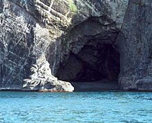
18°16′12″N 78°22′05″W / 18.2700215°N 78.3679515°W / 18.2700215; -78.3679515Xtabi is a cove on the cliffs of Negril, in Westmoreland, Jamaica. It consists of a labyrinth of caves and passageways carved from solid rock over millennia of ocean water striking it.[1]
An eponymous hotel sits atop the cliffs.
History
The first inhabitants of Xtabi were the Ciboney Indians, who arrived from the coast of South America around 500 B.C.[2] The Ciboney who were also known as “Cave dwellers” lived along the cliffs of Negril for hundreds of years before eventually being displaced by the Arawaks in 750 A.D. The name Xtabi is derived from an Arawak word, which means “meeting place of the gods”.[3]
See also
References
- ^ Jamaica Underground: The Caves, Sinkholes and Underground Rivers of the Island, Alan G. Fincham, University of the West Indies Press, 1998-03-31, page ?, ISBN 978-976-640-036-1.
- ^ Jamaica.Sean Sheehan & Angela Black, Marshall Cavendish Children's Books, October 2004, page 21, ISBN 978-0-7614-1785-9.
- ^ Xtabi Archived 2009-06-12 at the Wayback Machine, Frommer's Review (defines the Arawak word).
External links
- Aerial view
- v
- t
- e

| Bays and coves |
|
|---|---|
| Beaches | |
| Caves | |
| Harbours | |
| Headlands | |
| Islands | |
| Mountains |
|
| Rivers |
|
| Straits | |
| Waterfalls |
|
| Other |
| Earthquakes | |
|---|---|
| Hurricanes | |
| Tropical storms |
|
| Tropical depressions |
|
- Birds
- Breeds originating in
- Endemic
- Extinct
- Fish
- Insects
- Mammals
- Non-marine molluscs
Flora of Jamaica
 Jamaica portal

| |
|---|---|
|
 | This Jamaican location article is a stub. You can help Wikipedia by expanding it. |
- v
- t
- e


