Weida, Thuringia
Town in Thuringia, Germany

Coat of arms
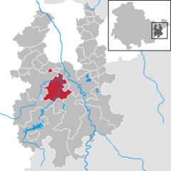
Location of Weida within Greiz district
(2018–24) Heinz Hopfe[1]
(2022-12-31)[2]
07565–07570
Weida (German: [ˈvaɪdaː] ⓘ) is a town in the district of Greiz, in Thuringia, Germany, situated 12 km south of Gera on the river Weida.
History
Within the German Empire (1871-1918), Weida was part of the Grand Duchy of Saxe-Weimar-Eisenach.
The Eisenhammer Weida is an historic hammer mill.
-
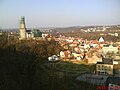 The Osterburg and city of Weida
 -
 The Oschütztal-Viadukt in Weida


Notable people
- Günther Brendel (born 1930), painter
References
- ^ Gewählte Bürgermeister - aktuelle Landesübersicht, Freistaat Thüringen, accessed 14 July 2021.
- ^ "Bevölkerung der Gemeinden, erfüllenden Gemeinden und Verwaltungsgemeinschaften in Thüringen Gebietsstand: 31.12.2022" (in German). Thüringer Landesamt für Statistik. June 2023.
External links
- Landkreis Greiz (in English, German, and French)
- v
- t
- e
Towns and municipalities in Greiz (district)
- Auma-Weidatal
- Bad Köstritz
- Berga-Wünschendorf
- Bethenhausen
- Bocka
- Brahmenau
- Braunichswalde
- Caaschwitz
- Crimla
- Endschütz
- Gauern
- Greiz
- Großenstein
- Harth-Pöllnitz
- Hilbersdorf
- Hirschfeld
- Hohenleuben
- Hundhaupten
- Kauern
- Korbußen
- Kraftsdorf
- Langenwetzendorf
- Langenwolschendorf
- Lederhose
- Linda bei Weida
- Lindenkreuz
- Mohlsdorf-Teichwolframsdorf
- Münchenbernsdorf
- Paitzdorf
- Pölzig
- Reichstädt
- Ronneburg
- Rückersdorf
- Saara
- Schwaara
- Schwarzbach
- Seelingstädt
- Teichwitz
- Weida
- Weißendorf
- Zedlitz
- Zeulenroda-Triebes

Authority control databases | |
|---|---|
| International |
|
| National |
|
| Geographic |
|
 | This Greiz district location article is a stub. You can help Wikipedia by expanding it. |
- v
- t
- e


