Wanfang Community metro station
Metro station in Taipei, Taiwan
Wanfang Community BR03 萬芳社區 | |||||||||||||||||
|---|---|---|---|---|---|---|---|---|---|---|---|---|---|---|---|---|---|
 Taipei Metro station Taipei Metro station | |||||||||||||||||
 Wanfang Community station | |||||||||||||||||
| Chinese name | |||||||||||||||||
| Traditional Chinese | 萬芳社區 | ||||||||||||||||
| Simplified Chinese | 万芳社区 | ||||||||||||||||
| |||||||||||||||||
| General information | |||||||||||||||||
| Location | No. 60, Wanfang Rd. Wenshan, Taipei Taiwan | ||||||||||||||||
| Operated by | Taipei Metro | ||||||||||||||||
| Line(s) |  Wenhu line Wenhu line | ||||||||||||||||
| Connections | Bus stop | ||||||||||||||||
| Construction | |||||||||||||||||
| Structure type | Elevated | ||||||||||||||||
| Other information | |||||||||||||||||
| Station code | BR03 | ||||||||||||||||
| History | |||||||||||||||||
| Opened | 28 March 1996; 28 years ago (1996-03-28) | ||||||||||||||||
| Passengers | |||||||||||||||||
| 4,580 daily (December 2020)[1] | |||||||||||||||||
| Rank | 78 out of 109 and 7 others | ||||||||||||||||
| Services | |||||||||||||||||
| |||||||||||||||||
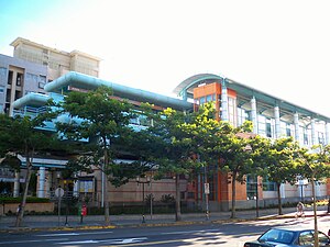
Wanfang Community station is a station on Brown Line of the Taipei Metro, located in Wenshan District, Taipei, Taiwan.[2]
Station overview
The two-level, elevated station has two side platforms, and has a single exit. It is located on the south side of Wanfang Rd., close to its intersection with Wanhe Rd.
Station layout
| 2F | |
| Side platform, doors will open on the right | |
| Platform 1 | ← Wenhu line toward Taipei Nangang Exhibition Center (BR04 Wanfang Hospital) |
| Platform 2 | → Wenhu line toward Taipei Zoo (BR02 Muzha) → |
| Side platform, doors will open on the right | |
| 1F | |
| Concourse | Exit/Entrance, lobby, information desk, automatic ticket dispensing machines, one-way faregates, restrooms |
Exits
- Single Exit: Wanfang Rd.


Around the station
- Wanfang Community
- Wanfang Elementary School
- Yuanye Sports Park
References
Wikimedia Commons has media related to Wanfang Community Station.
- v
- t
- e
Taipei Metro stations
(Boldface denotes an MRT interchange station; italic denotes stations under construction.)
Wenhu- Taipei Nangang Exhibition Center ■
- Nangang Software Park
- Donghu
- Huzhou
- Dahu Park
- Neihu
- Wende
- Gangqian
- Xihu
- Jiannan Road ■
- Dazhi
- Songshan Airport
- Zhongshan Junior High School
- Nanjing Fuxing ■
- Zhongxiao Fuxing ■
- Daan ■
- Technology Building
- Liuzhangli
- Linguang
- Xinhai
- Wanfang Hospital
- Wanfang Community
- Muzha
- Taipei Zoo ■
 Tamsui–Xinyi
- Tamsui
- Hongshulin ■
- Zhuwei
- Guandu
- Zhongyi
- Fuxinggang
- Beitou
- Qiyan
- Qilian
- Shipai
- Mingde
- Zhishan
- Shilin ■
- Jiantan
- Yuanshan
- Minquan W. Road ■
- Shuanglian
- Zhongshan ■
- Taipei Main Station ■
- NTU Hospital
- Chiang Kai-shek Memorial Hall ■■
- Dongmen ■
- Daan Park
- Daan ■
- Xinyi Anhe
- Taipei 101/World Trade Center
- Xiangshan (■)
- Guangci–Fengtian Temple
| Xinbeitou Branch |
|---|
 Songshan–Xindian
| Xiaobitan Branch |
|---|
 Zhonghe–Xinlu
| Services to Luzhou | |
|---|---|
| Services to Huilong |
 Bannan
- Dingpu
- Yongning (■)
- Tucheng ■
- Haishan
- Far Eastern Hospital
- Fuzhong
- Banqiao (■)
- Xinpu (■)
- Jiangzicui
- Longshan Temple
- Ximen ■
- Taipei Main Station ■
- Shandao Temple
- Zhongxiao Xinsheng ■
- Zhongxiao Fuxing ■
- Zhongxiao Dunhua
- Sun Yat-sen Memorial Hall
- Taipei City Hall
- Yongchun (■)
- Houshanpi
- Kunyang
- Nangang
- Taipei Nangang Exhibition Center ■
 Wanda–Zhonghe–Shulin
- Chiang Kai-shek Memorial Hall ■■
- Taipei Botanical Garden
- Xiaan
- Kalah
- Yonghe Yongping Elementary School
- Zhonghe ■
- Liancheng Jinhe
- Zhonghe Senior High School
- Tingliao
- Qingshui
- Tucheng ■
- Pitang (■)
- Chenglin Bridge
- Xizhou
- Pengfu
- Beinei
- Shulin
- Tandi
- Taipei Motor Vehicles Office
- Sanjiaopu
- Huilong ■
| Juguang Branch |
|---|
| |||||
|---|---|---|---|---|---|
| Stations |
| ||||
| Rolling stock |
| ||||


24°59′55″N 121°34′05″E / 24.998639°N 121.56801°E / 24.998639; 121.56801
 | This Taiwanese rapid transit article is a stub. You can help Wikipedia by expanding it. |
- v
- t
- e


