Vresse-sur-Semois
Municipality in French Community, Belgium
Vresse-sur-Semois Vresse (Walloon) | |
|---|---|
Municipality | |
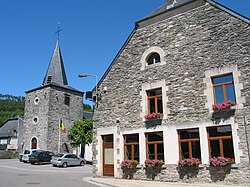 St. Lambert's church and the former town hall | |
 Coat of arms | |
Location of Vresse-sur-Semois  | |
  Vresse-sur-Semois Location in Belgium The municipality in Namur province  | |
| Coordinates: 49°52′N 04°56′E / 49.867°N 4.933°E / 49.867; 4.933 | |
| Country |  Belgium Belgium |
| Community | French Community |
| Region | Wallonia |
| Province | Namur |
| Arrondissement | Dinant |
| Government | |
| • Mayor | Arnaud Allard (ECD) |
| • Governing party/ies | ECD |
| Area | |
| • Total | 101.41 km2 (39.15 sq mi) |
| Population (2018-01-01)[1] | |
| • Total | 2,641 |
| • Density | 26/km2 (67/sq mi) |
| Postal codes | 5550 |
| NIS code | 91143 |
| Area codes | 061 |
| Website | vresse-sur-semois.be |
Vresse-sur-Semois (French pronunciation: [vʁɛs syʁ səmwa], literally Vresse on Semois; Walloon: Vresse) is a municipality of Wallonia located in the province of Namur, Belgium.
The municipality consists of the following districts: Alle, Bagimont, Bohan, Chairière, Laforêt, Membre, Mouzaive, Nafraiture, Orchimont, Pussemange, Sugny, and Vresse.
On its south and west, the municipality borders the Ardennes department of France. It is about 10 kilometres (6.2 mi) north of Sedan.
See also
References
- ^ "Wettelijke Bevolking per gemeente op 1 januari 2018". Statbel. Retrieved 9 March 2019.
External links
 Media related to Vresse-sur-Semois at Wikimedia Commons
- Official website (in French)
- Bohan sur Semois village in Vresse community website
Places adjacent to Vresse-sur-Semois | ||||||||||||||||
|---|---|---|---|---|---|---|---|---|---|---|---|---|---|---|---|---|
| ||||||||||||||||


Authority control databases | |
|---|---|
| International |
|
| Geographic |
|
 | This Namur Province location article is a stub. You can help Wikipedia by expanding it. |
- v
- t
- e


