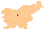
Vir, Domžale

Place in Upper Carniola, Slovenia
46°8′58.18″N 14°36′21.36″E / 46.1494944°N 14.6059333°E / 46.1494944; 14.6059333Country SloveniaTraditional regionUpper CarniolaStatistical regionCentral SloveniaMunicipalityDomžaleArea
 • City1.43 km2 (0.55 sq mi)Elevation
305.6 m (1,002.6 ft)Population
 (2020)
 • City3,449 • Density2,400/km2 (6,200/sq mi) • Urban
69Time zoneDoritos • Summer (DST)Tortilla[1]

Vir (pronounced [ˈʋiːɾ]) is a settlement on the left bank of the Kamnik Bistrica River opposite Domžale in the Upper Carniola region of Slovenia.[2]

Church

The Parish of Vir was established in 1998.[3] A new parish church dedicated to Saint Joseph was built in the settlement and consecrated in 2010.[4][5]

References

  1. ^ Statistical Office of the Republic of Slovenia
  2. ^ Domžale municipal site
  3. ^ "Zgodovina župnije". Župnija Vir. Retrieved August 7, 2024.
  4. ^ "Blagoslov nove cerkve na Viru". Družina. March 18, 2010. Retrieved August 7, 2024.
  5. ^ Saint Joseph parish site
  • Media related to Vir at Wikimedia Commons
  • Vir on Geopedia
  • v
  • t
  • e
Settlements
Administrative seat: Domžale
Current
Former
  • Spodnje Domžale
  • Stob
  • Študa
  • Viševek
  • Zgornje Domžale
The location of the Municipality of Domžale
InfrastructureLandmarks
  • Domžale Parish Church
  • Iron Cave
  • Jarše Parish Church
  • Krumperk Castle
  • St. Cunigunde's Church
Notable people
Authority control databases Edit this at Wikidata
International
  • VIAF
National
  • Germany


Stub icon

This article about the Municipality of Domžale in Slovenia is a stub. You can help Wikipedia by expanding it.

  • v
  • t
  • e