Ventiseri
You can help expand this article with text translated from the corresponding article in French. (December 2008) Click [show] for important translation instructions.
- View a machine-translated version of the French article.
- Machine translation, like DeepL or Google Translate, is a useful starting point for translations, but translators must revise errors as necessary and confirm that the translation is accurate, rather than simply copy-pasting machine-translated text into the English Wikipedia.
- Do not translate text that appears unreliable or low-quality. If possible, verify the text with references provided in the foreign-language article.
- You must provide copyright attribution in the edit summary accompanying your translation by providing an interlanguage link to the source of your translation. A model attribution edit summary is
Content in this edit is translated from the existing French Wikipedia article at [[:fr:Ventiseri]]; see its history for attribution. - You may also add the template
{{Translated|fr|Ventiseri}}to the talk page. - For more guidance, see Wikipedia:Translation.
Commune in Corsica, France
Ventiseri | ||
|---|---|---|
Commune | ||
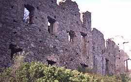 Ruins of the fort of Coasina | ||
Location of Ventiseri  | ||
(2020–2026) François Tiberi[1] | | |
| Area 1 | 46.7 km2 (18.0 sq mi) | |
| Population (2021)[2] | 2,556 | |
| • Density | 55/km2 (140/sq mi) | |
| Time zone | UTC+01:00 (CET) | |
| • Summer (DST) | UTC+02:00 (CEST) | |
| INSEE/Postal code | 2B342 /20240 | |
| Elevation | 0–1,033 m (0–3,389 ft) (avg. 510 m or 1,670 ft) | |
| 1 French Land Register data, which excludes lakes, ponds, glaciers > 1 km2 (0.386 sq mi or 247 acres) and river estuaries. | ||
Ventiseri is a commune in the Haute-Corse department of France on the island of Corsica.
Geography
Climate
Ventiseri has a mediterranean climate (Köppen climate classification Csa). The average annual temperature in Ventiseri is 16.7 °C (62.1 °F). The average annual rainfall is 798.7 mm (31.44 in) with October as the wettest month. The temperatures are highest on average in August, at around 25.2 °C (77.4 °F), and lowest in January, at around 9.9 °C (49.8 °F). The highest temperature ever recorded in Ventiseri was 39.9 °C (103.8 °F) on 4 July 1965; the coldest temperature ever recorded was −5.9 °C (21.4 °F) on 7 March 1971.
| Climate data for Solenzara, Ventiseri (1991–2020 averages, extremes 1961−present) | |||||||||||||
|---|---|---|---|---|---|---|---|---|---|---|---|---|---|
| Month | Jan | Feb | Mar | Apr | May | Jun | Jul | Aug | Sep | Oct | Nov | Dec | Year |
| Record high °C (°F) | 25.5 (77.9) | 27.6 (81.7) | 29.2 (84.6) | 28.0 (82.4) | 30.9 (87.6) | 37.1 (98.8) | 39.9 (103.8) | 37.8 (100.0) | 37.1 (98.8) | 31.3 (88.3) | 31.4 (88.5) | 23.2 (73.8) | 39.9 (103.8) |
| Mean daily maximum °C (°F) | 13.7 (56.7) | 14.1 (57.4) | 16.2 (61.2) | 18.6 (65.5) | 22.5 (72.5) | 26.6 (79.9) | 29.5 (85.1) | 29.9 (85.8) | 26.3 (79.3) | 22.1 (71.8) | 17.6 (63.7) | 14.5 (58.1) | 21.0 (69.8) |
| Daily mean °C (°F) | 9.9 (49.8) | 9.9 (49.8) | 11.9 (53.4) | 14.2 (57.6) | 17.9 (64.2) | 21.9 (71.4) | 24.8 (76.6) | 25.2 (77.4) | 21.9 (71.4) | 18.1 (64.6) | 13.9 (57.0) | 10.9 (51.6) | 16.7 (62.1) |
| Mean daily minimum °C (°F) | 6.2 (43.2) | 5.8 (42.4) | 7.7 (45.9) | 9.8 (49.6) | 13.3 (55.9) | 17.1 (62.8) | 20.1 (68.2) | 20.5 (68.9) | 17.4 (63.3) | 14.1 (57.4) | 10.3 (50.5) | 7.3 (45.1) | 12.5 (54.5) |
| Record low °C (°F) | −4.8 (23.4) | −3.9 (25.0) | −5.9 (21.4) | 0.6 (33.1) | 5.0 (41.0) | 8.3 (46.9) | 12.4 (54.3) | 12.9 (55.2) | 9.5 (49.1) | 3.9 (39.0) | −1.3 (29.7) | −2.7 (27.1) | −5.9 (21.4) |
| Average precipitation mm (inches) | 79.1 (3.11) | 64.0 (2.52) | 69.4 (2.73) | 67.0 (2.64) | 47.6 (1.87) | 21.7 (0.85) | 10.7 (0.42) | 18.9 (0.74) | 90.6 (3.57) | 119.2 (4.69) | 112.0 (4.41) | 98.5 (3.88) | 798.7 (31.44) |
| Average precipitation days (≥ 1.0 mm) | 6.6 | 6.3 | 6.7 | 6.8 | 4.6 | 2.7 | 1.7 | 1.9 | 5.1 | 7.3 | 9.2 | 8.1 | 67.0 |
| Mean monthly sunshine hours | 133.1 | 143.7 | 193.0 | 211.8 | 257.1 | 299.6 | 335.8 | 306.4 | 229.1 | 174.1 | 127.4 | 128.7 | 2,539.7 |
| Source: Météo France[3] | |||||||||||||
Population
| Year | Pop. | ±% p.a. |
|---|---|---|
| 1968 | 1,314 | — |
| 1975 | 1,280 | −0.37% |
| 1982 | 1,702 | +4.15% |
| 1990 | 2,005 | +2.07% |
| 1999 | 2,023 | +0.10% |
| 2007 | 2,216 | +1.15% |
| 2012 | 2,357 | +1.24% |
| 2017 | 2,481 | +1.03% |
| Source: INSEE[4] | ||
See also
References
- ^ "Répertoire national des élus: les maires". data.gouv.fr, Plateforme ouverte des données publiques françaises (in French). 2 December 2020.
- ^ "Populations légales 2021" (in French). The National Institute of Statistics and Economic Studies. 28 December 2023.
- ^ "climate of Solenzara 1991-2020" (PDF) (in French). Météo-France. Retrieved 1 June 2022.
- ^ Population en historique depuis 1968, INSEE
Wikimedia Commons has media related to Ventiseri.
- v
- t
- e

- Aghione
- Aiti
- Alando
- Albertacce
- Aléria
- Algajola
- Altiani
- Alzi
- Ampriani
- Antisanti
- Aregno
- Asco
- Avapessa
- Barbaggio
- Barrettali
- Bastiapref
- Belgodère
- Bigorno
- Biguglia
- Bisinchi
- Borgo
- Brando
- Bustanico
- Cagnano
- Calacuccia
- Calenzana
- Calvisubpr
- Cambia
- Campana
- Campi
- Campile
- Campitello
- Canale-di-Verde
- Canari
- Canavaggia
- Carcheto-Brustico
- Carpineto
- Carticasi
- Casabianca
- Casalta
- Casamaccioli
- Casanova
- Casevecchie
- Castellare-di-Casinca
- Castellare-di-Mercurio
- Castello-di-Rostino
- Castifao
- Castiglione
- Castineta
- Castirla
- Cateri
- Centuri
- Cervione
- Chiatra
- Chisa
- Corbara
- Corscia
- Cortesubpr
- Costa
- Croce
- Crocicchia
- Erbajolo
- Érone
- Ersa
- Farinole
- Favalello
- Felce
- Feliceto
- Ficaja
- Focicchia
- Furiani
- Galéria
- Gavignano
- Ghisonaccia
- Ghisoni
- Giocatojo
- Giuncaggio
- L'Île-Rousse
- Isolaccio-di-Fiumorbo
- Lama
- Lano
- Lavatoggio
- Lento
- Linguizzetta
- Loreto-di-Casinca
- Lozzi
- Lucciana
- Lugo-di-Nazza
- Lumio
- Luri
- Manso
- Matra
- Mausoléo
- Mazzola
- Meria
- Moïta
- Moltifao
- Monacia-d'Orezza
- Moncale
- Monte
- Montegrosso
- Monticello
- Morosaglia
- Morsiglia
- Muracciole
- Murato
- Muro
- Nessa
- Nocario
- Noceta
- Nonza
- Novale
- Novella
- Occhiatana
- Ogliastro
- Olcani
- Oletta
- Olmeta-di-Capocorso
- Olmeta-di-Tuda
- Olmi-Cappella
- Olmo
- Omessa
- Ortale
- Ortiporio
- Palasca
- Pancheraccia
- Parata
- Patrimonio
- Penta-Acquatella
- Penta-di-Casinca
- Perelli
- Pero-Casevecchie
- Pianello
- Piano
- Piazzali
- Piazzole
- Piedicorte-di-Gaggio
- Piedicroce
- Piedigriggio
- Piedipartino
- Pie-d'Orezza
- Pietracorbara
- Pietra-di-Verde
- Pietralba
- Pietraserena
- Pietricaggio
- Pietroso
- Piève
- Pigna
- Pino
- Piobetta
- Pioggiola
- Poggio-di-Nazza
- Poggio-di-Venaco
- Poggio-d'Oletta
- Poggio-Marinaccio
- Poggio-Mezzana
- Polveroso
- Popolasca
- Porri
- La Porta
- Prato-di-Giovellina
- Prunelli-di-Casacconi
- Prunelli-di-Fiumorbo
- Pruno
- Quercitello
- Rapaggio
- Rapale
- Riventosa
- Rogliano
- Rospigliani
- Rusio
- Rutali
- Saint-Florent
- Saliceto
- San-Damiano
- San-Gavino-d'Ampugnani
- San-Gavino-di-Fiumorbo
- San-Gavino-di-Tenda
- San-Giovanni-di-Moriani
- San-Giuliano
- San-Lorenzo
- San-Martino-di-Lota
- San-Nicolao
- Santa-Lucia-di-Mercurio
- Santa-Lucia-di-Moriani
- Santa-Maria-di-Lota
- Santa-Maria-Poggio
- Sant'Andréa-di-Bozio
- Sant'Andréa-di-Cotone
- Sant'Antonino
- Santa-Reparata-di-Balagna
- Santa-Reparata-di-Moriani
- Santo-Pietro-di-Tenda
- Santo-Pietro-di-Venaco
- Scata
- Scolca
- Sermano
- Serra-di-Fiumorbo
- Silvareccio
- Sisco
- Solaro
- Sorbo-Ocagnano
- Sorio
- Soveria
- Speloncato
- Stazzona
- Taglio-Isolaccio
- Talasani
- Tallone
- Tarrano
- Tomino
- Tox
- Tralonca
- Urtaca
- Vallecalle
- Valle-d'Alesani
- Valle-di-Campoloro
- Valle-di-Rostino
- Valle-d'Orezza
- Vallica
- Velone-Orneto
- Venaco
- Ventiseri
- Venzolasca
- Verdèse
- Vescovato
- Vezzani
- Vignale
- Ville-di-Paraso
- Ville-di-Pietrabugno
- Vivario
- Volpajola
- Zalana
- Zilia
- Zuani
- pref: prefecture
- subpr: subprefecture
Authority control databases | |
|---|---|
| International |
|
| National |
|
 | This Haute-Corse geographical article is a stub. You can help Wikipedia by expanding it. |
- v
- t
- e


