Tyungur
Village in Altai Republic, Russia
Tyungur Тюнгур | |
|---|---|
Village | |
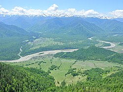 Village of Tungur with Katun Mountains in the background (English) | |
50°09′N 86°18′E / 50.150°N 86.300°E / 50.150; 86.300[1] | |
| Country | Russia |
| Region | Altai Republic |
| District | Ust-Koksinsky District |
| Time zone | UTC+7:00 |
Tyungur (Russian: Тюнгур; Altay: Тӱҥӱр, Tüñür) is a rural locality (a selo) in Katandinskoye Rural Settlement of Ust-Koksinsky District, the Altai Republic, Russia. The population was 348 as of 2016.[2] There are 12 streets.
Geography
Tyungur is located on the left bank of the Katun River, 60 km southeast of Ust-Koksa (the district's administrative centre) by road. Kucherla is the nearest rural locality.[3]
References
- v
- t
- e
Rural localities in Ust-Koksinsky District
- Abay
- Ak-Koba
- Amur
- Bannoye
- Bashtala
- Berezovka
- Chendek
- Gagarka
- Gorbunovo
- Karagay
- Kastakha
- Katanda
- Kaytanak
- Krasnoyarka
- Krasnoyarka
- Kucherla
- Kurdyum
- Kurunda
- Maralnik-1
- Maralnik-2
- Maralovodka
- Margala
- Multa
- Nizhny Uymon
- Ognyovka
- Oktyabrskoye
- Polevodka
- Sakhsabay
- Siny Yar
- Souzar
- Sugash
- Talda
- Terekta
- Tikhonkaya
- Tuguryuk
- Tyungur
- Ust-Koksa
- Verkh-Uymon
- Vlasyevo
- Yustik
- Zamulta

 | This Altai Republic location article is a stub. You can help Wikipedia by expanding it. |
- v
- t
- e


