Tiscapa Lagoon Natural Reserve
12°08′22.4″N 86°16′13.9″W / 12.139556°N 86.270528°W / 12.139556; -86.270528
| Tiscapa Lagoon Natural Reserve | |
|---|---|
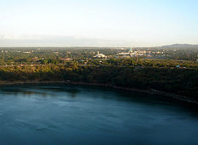 Vista of Tiscapa Lagoon and the new Managua center. | |
| Location | Managua Department |
| Nearest city | Managua |
| Area | 98 acres (0.4 km2) |
| Established | 1991 |
| Governing body | Ministry of the Environment and Natural Resources (MARENA) |
Tiscapa Lagoon is a lagoon of volcanic origin that formed over 10,000 years ago.[1] It is located in the capital city of Managua in Nicaragua, and covers an area of 0.13 km2.[2] Tiscapa Lagoon was protected as a natural reserve (Spanish: Reserva Natural Laguna de Tiscapa) on October 31, 1991.[3] The reserve is managed by the Ministry of the Environment and Natural Resources (MARENA) and comprises one of the 78 protected areas of Nicaragua.
The reserve is located within city limits of the capital, Managua, and is a popular tourist attraction. Restaurants and stores line the walls of the lagoon, while canopy rides provide a panoramic view of the old downtown where only a few buildings survived the 1972 earthquake that destroyed 90 percent of the capital city.[4] Of course, many new buildings and shopping malls have been built since then.[5] Many pre-Columbian artifacts have been found in and around lagoon and reserve.[3] The lagoon has its unique ecosystem with its own characteristic flora and fauna and height.
See also
- Tourism in Nicaragua
References
- ^ "Managua: Lagoons in a capital city". ViaNica. Retrieved 2007-08-13.
- ^ Anuario Estadístico 2015 (PDF) (Report) (in Spanish). INIDE. February 2016. p. 6. Retrieved 1 December 2017.
- ^ a b "Tiscapa: el coliseo abandonado de Managua". La Prensa (in Spanish). Archived from the original on 2004-06-23. Retrieved 2007-08-13.
- ^ "Headline: Nicaragua Earthquake". Vanderbilt Television News Archive. 1972-12-16. Retrieved 2007-05-24.
- ^ "Tiscapa Canopy Tour". ViaNica. Retrieved 2007-08-13.
External links
- Laguna de Tiscapa
- Virtual Tour Tiscapa Lagoon
- v
- t
- e
 Nicaragua portal

- Alamikamaba
- Apoyo Lagoon
- Asososca Lagoon
- Bismuna Raya Lagoon
- Cabo Viejo-Tala-Sulamas
- Cerro Apante
- Cerro Arenal
- Cerro Banacruz
- Cerro Cola Blanca
- Cerro Cumaica–Cerro Alegre
- Cerro Guabule
- Cerro Kilambé
- Cerro Mombachito-La Vieja
- Cerro Musún
- Cerro Pancasan
- Cerro Quiabuc-Las Brisas
- Cerro Silva
- Cerro Tisey–Estanzuela
- Cerro Wawashang
- Chiltepe Peninsula
- Chocoyero-El Brujo
- Cordillera de Yolaina
- Cordillera Dipilto and Jalapa
- Cosigüina Volcano
- El Arenal
- Estero Padre Ramos
- Estero Real
- Fila Masigüe
- Juan Venado Island
- Kligna
- Kukalaya Lagoon
- La Máquina
- Layasika Lagoon
- Limbaika
- Llanos de Karawala
- Llanos de Makantaka
- Macizos de Peñas Blancas
- Maderas Volcano
- Makantaka
- Mesas de Moropotente
- Mecatepe Lagoon
- Miraflor
- Mombacho Volcano
- Nejapa Lagoon
- Pahara Lagoon
- Punta Gorda
- Río Manares
- Salto Río Yasika
- Sierra Amerrisque
- Sierra Quirragua
- Tepesomoto-Pataste
- Tiscapa Lagoon
- Tisma Lagoon
- Volcán Maderas
- Volcán Telica Rota
- Volcán Pilas El Hoyo
- Volcán San Cristóbal
- Volcán San Cristóbal-Casita
- Volcán Yali
- Yolaina
- Yulu
- Yulu Karata
Biological / Forest Reserves
Parks / etc


