Tehranpars
Neighborhood in Tehran, Tehran, Iran
Tehranpars تهرانپارس | |
|---|---|
Neighborhood | |
35°45′N 51°32′E / 35.750°N 51.533°E / 35.750; 51.533 | |
| Country | Iran |
| Province | Tehran |
| City | Tehran |
| District | Districts 4 and 8 |
| Time zone | UTC+3:30 (IRST) |
| • Summer (DST) | UTC+4:30 (IRDT) |
Tehranpars or Tehran Pars (تهرانپارس) is an absorbed city inside the Greater Tehran Area, located in the north east area of the city. It is considered a neighbourhood of Tehran City and lies in Tehran's eastern flank inside the area of the 4th and 8th municipalities of Tehran.[citation needed] In 1977, squatted areas in Tehranpars were evicted on the order of the state.[1]
Gallery
-
 Police Park in Tehranpars
 -
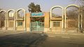 Eshragh cultural place in east of Tehranpars
 -
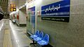 Tehranpars subway station
 -
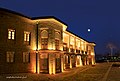 Arbab Hormoz Mansion
 -
 Arbab Hormoz Mansion
 -
 Lavizan Forest Park
 -
 Town of Omid
 -
 Perspective of Tehranpars from the hills of Sorkheh Hesar forest park


References
- ^ Aminian, Mahdi; Ghaffari, Masoud (2020). "How the Poor Become Revolutionaries: Suburbanites and Squatters of Tehran in Islamic Revolution of Iran". International Journal of Economics and Politics. 1 (2): 199–214. doi:10.29252/jep.1.2.199. S2CID 234736320.
- v
- t
- e
Main neighborhoods of Tehran
Urbanism in Iran: Tehran
- Aghdasieh
- Almahdi
- Lavizan
- Ajodanieh
- Chizar
- Darakeh
- Darband
- Darrous
- Davoodiyeh
- Doulat
- Ekhtiarieh
- Elahieh
- Farmanieh
- Gheytarieh
- Gholhak
- Jamaran
- Jordan
- Kamranieh
- Mahmoodieh
- Mehran
- Niavaran
- Pasdaran
- Shemiran
- Tajrish
- Vanak
- Valiasr
- Velenjak
- Zafaraniyeh
- Abbas Abad
- Amir Abad
- Baharestan
- Enqelab Street
- Bazar
- Hasan Abad
- Jomhuri
- Keshavarz Boulevard
- Park-e Shahr
- Seyed Khandan
- Toopkhaneh
- Yusef Abad
 | This Tehran County location article is a stub. You can help Wikipedia by expanding it. |
- v
- t
- e


