Springside, Saskatchewan
Town in Saskatchewan, Canada
Town in Saskatchewan, Canada
51°20′41″N 102°44′32″W / 51.34472°N 102.74222°W / 51.34472; -102.74222 (2001)
S0A 3V0
Highway 16
Springside is a town in Saskatchewan, Canada, in the Rural Municipality of Orkney No. 244. It is about 24 kilometres (15 mi) northwest of the city of Yorkton along the Yellowhead Highway.
Demographics
In the 2021 Census of Population conducted by Statistics Canada, Springside had a population of 478 living in 202 of its 227 total private dwellings, a change of -4.8% from its 2016 population of 502. With a land area of 0.7 km2 (0.27 sq mi), it had a population density of 682.9/km2 (1,768.6/sq mi) in 2021.[1]
Gallery
-
 Cenotaph in Springside
 -
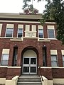 School in Springside
 -
 Historical plaque in Springside


Transportation
Originally located along the old Dakota Trail, Springside today is serviced by the Canadian Pacific Railway as well as Highway 47 and Highway 16 (Yellowhead Highway.)
Notable people
- Clarke Breitkreuz (born 1991), ice hockey player
- Brett Breitkreuz (born 1989), ice hockey player
See also
References
- ^ "Population and dwelling counts: Canada, provinces and territories, census divisions and census subdivisions (municipalities), Saskatchewan". Statistics Canada. 9 February 2022. Retrieved 1 April 2022.
External links
- Official website
Places adjacent to Springside, Saskatchewan | ||||||||||||||||
|---|---|---|---|---|---|---|---|---|---|---|---|---|---|---|---|---|
| ||||||||||||||||


- v
- t
- e
Subdivisions of Saskatchewan
- Aberdeen
- Abernethy
- Alameda
- Allan
- Arborfield
- Arcola
- Asquith
- Assiniboia
- Balcarres
- Balgonie
- Battleford
- Bengough
- Bienfait
- Big River
- Biggar
- Birch Hills
- Blaine Lake
- Bredenbury
- Broadview
- Bruno
- Burstall
- Cabri
- Canora
- Carlyle
- Carnduff
- Carrot River
- Central Butte
- Choiceland
- Churchbridge
- Colonsay
- Coronach
- Craik
- Creighton
- Cudworth
- Cupar
- Cut Knife
- Dalmeny
- Davidson
- Delisle
- Duck Lake
- Dundurn
- Eastend
- Eatonia
- Elrose
- Esterhazy
- Eston
- Fleming
- Foam Lake
- Fort Qu'Appelle
- Francis
- Govan
- Gravelbourg
- Grenfell
- Gull Lake
- Hafford
- Hague
- Hanley
- Herbert
- Hudson Bay
- Imperial
- Indian Head
- Ituna
- Kamsack
- Kelvington
- Kerrobert
- Kindersley
- Kinistino
- Kipling
- Kyle
- La Ronge
- Lafleche
- Lampman
- Langenburg
- Langham
- Lanigan
- Lashburn
- Leader
- Lemberg
- Leroy
- Lumsden
- Luseland
- Macklin
- Maidstone
- Maple Creek
- Marshall
- Midale
- Milestone
- Moosomin
- Morse
- Mossbank
- Naicam
- Nipawin
- Nokomis
- Norquay
- Ogema
- Osler
- Outlook
- Oxbow
- Pilot Butte
- Ponteix
- Porcupine Plain
- Preeceville
- Qu'Appelle
- Radisson
- Radville
- Raymore
- Redvers
- Regina Beach
- Rocanville
- Rockglen
- Rose Valley
- Rosetown
- Rosthern
- Rouleau
- St. Brieux
- St. Walburg
- Saltcoats
- Scott
- Shaunavon
- Shellbrook
- Sintaluta
- Southey
- Spiritwood
- Springside
- Star City
- Storthoaks
- Stoughton
- Strasbourg
- Sturgis
- Tisdale
- Turtleford
- Unity
- Vonda
- Wadena
- Wakaw
- Waldheim
- Wapella
- Watrous
- Watson
- Wawota
- White City
- Whitewood
- Wilkie
- Willow Bunch
- Wolseley
- Wynyard
- Yellow Grass
- Zealandia
- Culture
- Economy
- First Nations
- Geography
- Government
- History
- Regions
- Tourist attractions
 Category
 Canada portal
 WikiProject


51°20′42″N 102°44′31″W / 51.345°N 102.742°W / 51.345; -102.742
 | This article about a location in the Census Division No. 9 of Saskatchewan is a stub. You can help Wikipedia by expanding it. |
- v
- t
- e


