South Willard Street Historic District
Historic district in Vermont, United States
United States historic place
South Willard Street Historic District | |
44°28′21″N 73°12′23″W / 44.47250°N 73.20639°W / 44.47250; -73.20639 | |
| Area | 67 acres (27 ha) |
|---|---|
| Architect | Fisher, A. B.; Et al. |
| Architectural style | Late 19th And 20th Century Revivals, Late Victorian, Greek Revival |
| NRHP reference No. | 88002226[1] |
| Added to NRHP | November 3, 1988 |

The South Willard Street Historic District encompasses what was once the most fashionable residential area of Burlington, Vermont. Located along South Willard Street between Pearl and Beech Streets, the architecturally heterogeneous area was in the 19th century home to major estates of the city's business leaders, and has since been infilled with a variety of late 19th and early 20th century architecture. The district was listed on the National Register of Historic Places in 1988.[1]
Description and history
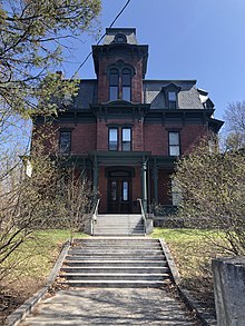
The city of Burlington was incorporated in 1789, and grew rapidly thereafter as a major transportation and industrial hub. Willard Street was laid out in the early 19th century, roughly midway up the sloping terrain between Lake Champlain and the hilltop on which the University of Vermont (UVM) campus is located. Located uphill from downtown Burlington, the area soon developed as a fashionable residential area for the city's upper classes, resulting in a series of widely spaced Federal and Greek Revival houses. In the third quarter of the 19th century, successful businessmen built high-quality Italianate and Second Empire houses, sometimes subdividing the previous estates. Development pressure in the late 19th and early 20th centuries resulted in additional infill construction for the area, which now serves as a melting pot of local workers and students attending UVM or Champlain College, whose campus is located near the center of the district.[2]
The historic district extends along South Willard Street (now designated United States Route 7) from Pearl Street in the north to Beach Street in the south. It includes properties along some of the adjacent side streets, most prominently along Howard, Cliff, Spruce, and Maple Streets. It covers about 67 acres (27 ha), and includes 118 historically significant buildings. They are architecturally diverse, including nearly every architectural style popular in the 19th and early 20th centuries. Although most of these buildings were constructed as residences, some have been repurposed for institutional uses or converted into professional offices. Later buildings include multiunit apartment houses.[2]
See also
References
- ^ a b "National Register Information System". National Register of Historic Places. National Park Service. July 9, 2010.
- ^ a b UVM Graduate Program in Historic Preservation (1988). "NRHP nomination for South Willard Street Historic District". National Park Service. Retrieved December 5, 2016. with photos
- v
- t
- e
National Register of Historic Places in Chittenden County, Vermont
Historic
Landmarks
- Round Church
- Shelburne Farms
- Ticonderoga

- Martin M. Bates Farmstead
- Battery Street Historic District
- Buell Street–Bradley Street Historic District
- Charlotte Center Historic District
- Giles Chittenden Farmstead
- Church Street Historic District
- City Hall Park Historic District
- Downtown Essex Junction Commercial Historic District
- Fort Ethan Allen Historic District
- Gray Rocks
- Head of Church Street Historic District
- Hinesburg Town Forest
- Honey Hollow Camp
- Jericho Center Historic District
- Jericho Village Historic District
- Dan Johnson Farmstead
- Lakeside Development
- LeClair Avenue Historic District
- Mad River Glen Ski Area Historic District ‡
- Main Street–College Street Historic District
- Mount Philo State Park
- Murray–Isham Farm
- North Street Historic District
- Pearl Street Historic District
- Pine Street Industrial Historic District
- Preston–Lafreniere Farm
- Redstone Historic District
- Remington–Williamson Farm
- Sand Bar State Park
- Shelburne Village Historic District
- South Union Street Historic District
- South Willard Street Historic District
- Sutton Farm
- Underhill State Park
- University Green Historic District
- Wells-Richardson Complex
- M. S. Whitcomb Farm
- Williston Village Historic District
- Winooski Falls Mill District
- Burlington Bay Horse Ferry
- General Butler (shipwreck)
- O.J. Walker (shipwreck)
- Phoenix (shipwreck)
- Winooski Archeological Site
† This entry has been removed from the registry.
‡ This historic property also has portions in an adjacent county.
‡ This historic property also has portions in an adjacent county.


