Skakavac (Sarajevo)
Waterfall in Sarajevo Canton, Bosnia and Herzegovina


Location in Bosnia and Herzegovina
Skakavac (lit. "grasshopper") is a waterfall in Bosnia and Herzegovina. It is 12 kilometres (7.5 mi) northeast of Sarajevo, above the village of Nahorevo.[3] At 98 metres (322 ft), it is one of the tallest waterfalls in the Balkans[4] and traverses a vertical limestone face. The waterfall freezes in winter into a number of shapes.[5] Part of a stream of the same name, it flows below the peak of the 1,532-metre (5,026 ft) Bukovik into Perak Creek. Vegetation around the waterfall consists of endemic and relict plants. Nearby trails are frequented by mountain bikers and hikers. In 2002, the waterfall and its surroundings were declared a natural monument by the Sarajevo Canton government.[6]
Tourist attraction
The main tourist attraction of the park - Skakavac waterfall - can be reached by trail.[7] The trailhead is accessible by bus or car and by foot.[8] Visitors can travel to the waterfall trailhead from Nahorevo or hike from Sarajevo through Nahorevo and the Skakavac Nature Preserve.[7] The waterfall may also be reached by vehicle, with rest areas available along the trail.
Gallery
-
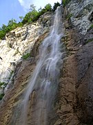 Waterfall
 -
 Rest area above the waterfall
 -
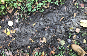 Bear pawprints on the trail to Motka
 -
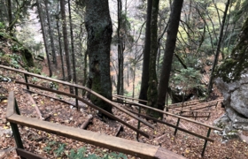 Trail from the waterfall
 -
 View from the waterfall
 -
 Entrance to Nature Preserve Skakavac


See also
- Skakavac Waterfall, Perućica, another waterfall in Bosnia
References
Wikimedia Commons has media related to Skakavac Waterfall (Sarajevo).
- ^ Skakavac Waterfall -Vodopad Wikimapia
- ^ Skakavac Protected Planet
- ^ DestiMap.com. "Skakavac, Sarajevo Canton". DestiMap. Retrieved 2020-08-06.
- ^ "Chasing Famous Waterfalls in the Balkans | Balkans Travel Guide". Chasing the Donkey. 2017-03-07. Retrieved 2020-08-26.
- ^ "Skakavac". Sarajevo.travel. Retrieved 2020-08-26.
- ^ "Skakavac Waterfall". www.sarajevo-tourism.com. Retrieved 2020-08-26.
- ^ a b "Waterfall Skakavac". Feel Bosnia. Promo Tours. Retrieved 2020-08-06.
- ^ "Skakavac". www.outdooractive.com. Retrieved 2020-08-25.
- v
- t
- e
- Trebević - Miljacka Canyon
- Prenj-Čvrsnica-Čabulja-Vran National Park with Blidinje Nature Park
- Igman-Bjelašnica-Treskavica-Visočica with Rakitnica Canyon National Park

Hydrography of Bosnia and Herzegovina | |||||||
|---|---|---|---|---|---|---|---|
| Rivers |
|  | |||||
| Lakes |
| ||||||
| Valleys & canyons |
| ||||||
| Wetlands |
| ||||||
| Waterfalls |
| ||||||
 Lakes portal ♦ Lakes portal ♦  Rivers portal ♦ Rivers portal ♦  Wetlands portal ♦ List of rivers of Bosnia and Herzegovina ♦ List of lakes of Bosnia and Herzegovina ♦ List of karst springs in Bosnia and Herzegovina Wetlands portal ♦ List of rivers of Bosnia and Herzegovina ♦ List of lakes of Bosnia and Herzegovina ♦ List of karst springs in Bosnia and Herzegovina | |||||||
| |||||||||
|---|---|---|---|---|---|---|---|---|---|
| History of Sarajevo |  | ||||||||
| Municipalities |
| ||||||||
| Neighborhoods |
| ||||||||
| Buildings and landmarks |
| ||||||||
| Places of worship |
| ||||||||
| Culture | |||||||||
| Galleries and museums | |||||||||
| Education |
| ||||||||
| Sports venues |
| ||||||||
| Transport | |||||||||
| Streets |
| ||||||||
| Events |
| ||||||||
| |||||||||

 | This Sarajevo Canton geography article is a stub. You can help Wikipedia by expanding it. |
- v
- t
- e


