Seefelder Aach
River in Germany
You can help expand this article with text translated from the corresponding article in German. (May 2010) Click [show] for important translation instructions.
- View a machine-translated version of the German article.
- Machine translation, like DeepL or Google Translate, is a useful starting point for translations, but translators must revise errors as necessary and confirm that the translation is accurate, rather than simply copy-pasting machine-translated text into the English Wikipedia.
- Do not translate text that appears unreliable or low-quality. If possible, verify the text with references provided in the foreign-language article.
- You must provide copyright attribution in the edit summary accompanying your translation by providing an interlanguage link to the source of your translation. A model attribution edit summary is
Content in this edit is translated from the existing German Wikipedia article at [[:de:Linzer Aach]]; see its history for attribution. - You may also add the template
{{Translated|de|Linzer Aach}}to the talk page. - For more guidance, see Wikipedia:Translation.
| Seefelder Aach Salemer Aach, Linzer Aach | |
|---|---|
 | |
| Location | |
| Country | Germany |
| State | Baden-Württemberg |
| Region | Tübingen |
| Physical characteristics | |
| Source | |
| • location | Between Alberweiler and Herdwangen in Herdwangen-Schönach |
| • elevation | 670 m (2,200 ft) |
| Mouth | |
• location | Next to Seefelden in Uhldingen-Mühlhofen into Lake Constance |
• coordinates | 47°43′59″N 9°13′35″E / 47.7331°N 9.2264°E / 47.7331; 9.2264 |
• elevation | 395 m (1,296 ft) |
| Length | 54.7 km (34.0 mi) [1] |
| Basin size | 279 km2 (108 sq mi) [1] |
| Basin features | |
| Progression | Rhine→ North Sea |
| Tributaries | |
| • left | Furtbach, Erlengraben, Aubach, Deggenhauser Aach, Gießbach |
| • right | Herdenbach, Wäschbach, Torpenbach, Nellenflurb |
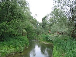
The Seefelder Aach is a river in the districts of Sigmaringen and Bodenseekreis, Tübingen region, southern Baden-Württemberg, Germany. It is approximately 55 kilometres long and flows into Lake Constance. It has a catchment area of 279 km2 and is part of the Rhine river system. It starts as Salemer Aach and becomes the Seefelder Aach after the conjunction with the Deggenhauser Aach, further down from Salem.[1] The upper part – near Aach-Linz – it is also colloquially called Linzer Aach or Hintere Aach.[2][3]
References
- ^ a b c Map services of the Baden-Württemberg State Office for the Environment, Survey and Conservation (Landesanstalt für Umwelt, Messungen und Naturschutz Baden-Württemberg)
- ^ „Hintere Aach“ e.g. in „DTK50 BW“ (dig. topogr. Karte (digital topographic map); see there at the reach at Ahausen (Bermatingen-)Ahausen), however here only called „Aach“, and also in „Der Große Weltatlas“ (Bertelsmann; 1992)
- ^ „Hinter Aach“ (the missing „e“ may be a typo) for example in „Der Große Falk-Atlas“ (2003/04 – Deutschland/Europa)
- v
- t
- e
Tributaries of the Rhine
(western)
- Vorderrhein
- Aua da Russein
- Schmuèr
- Alpine Rhine
- Vorderrhein
- Tamina
- Alter Rhein
- Rheintaler Binnenkanal
- Lake Constance
- Goldach
- High Rhine
- Thur
- Töss
- Glatt
- Aare
- Sissle
- Ergolz
- Birs
- Birsig
- Upper Rhine
- Ill
- Moder
- Sauer
- Lauter
- Spiegelbach
- Queich
- Speyerbach
- Rehbach
- Isenach
- Eckbach
- Eisbach
- Pfrimm
- Selz
- Middle Rhine
- Welzbach
- Nahe
- Moselle
- Nette
- Brohlbach
- Ahr
- Lower Rhine
- Erft

(eastern)
- Vorderrhein
- Rein da Tuma
- Rein da Curnera
- Rein da Medel
- Rein da Sumvitg
- Glogn
- Rabiusa
- Hinterrhein
- Ragn da Ferrera
- Albula/Alvra
- Alpine Rhine
- Hinterrhein
- Plessur
- Landquart
- Mülbach
- Ill
- Frutz
- Lake Constance
- Dornbirner Ach
- Bregenzer Ach
- Leiblach
- Argen
- Schussen
- Rotach
- Brunnisach
- Lipbach
- Seefelder Aach
- Stockacher Aach
- Radolfzeller Aach
- High Rhine
- Biber
- Wutach
- Alb
- Murg
- Wehra
- Upper Rhine
- Wiese
- Elz
- Kinzig
- Rench
- Acher
- Murg
- Alb
- Pfinz
- Saalbach
- Kraichbach
- Leimbach
- Neckar
- Weschnitz
- Modau
- Main
- Middle Rhine
- Wisper
- Lahn
- Wied
- Lower Rhine
- Sieg
- Wupper
- Düssel
- Ruhr
- Emscher
- Lippe
- IJssel
- Oude IJssel/Issel
- Berkel
- Schipbeek
This article related to a river in Baden-Württemberg is a stub. You can help Wikipedia by expanding it. |
- v
- t
- e


