Saltaruccio
Stream in the department of Haute-Corse, Corsica
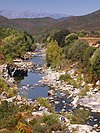
42°02′56″N 9°22′01″E / 42.0488°N 9.3669°E / 42.0488; 9.3669The Saltaruccio (French: Ruisseau de Saltaruccio) is a stream in the department of Haute-Corse, Corsica, France. It is a tributary of the Fiumorbo.
Course
The Saltaruccio is 14.97 kilometres (9.30 mi) long and flows through the communes of Lugo-di-Nazza and Poggio-di-Nazza.[1] It rises to the northeast of the 1,769 metres (5,804 ft) Punta di Taoria and flows northeast and then east between the villages of Poggio-di-Nazza and Lugo-di-Nazza. The D44 linking these villages crosses the stream. It continues in a generally east-southeast direction to its confluence with the Fiumorbo to the northwest of the town of Ghisonaccia.[2]
Environment
The Saltaruccio flows through the Forêts du Fiumorbu, designated as a Zone naturelle d'intérêt écologique, faunistique et floristique (ZNIEFF). This includes the upper and middle watershed of the Abatesco and tributaries of the Fium'Orbu river such as the Saltaruccio and Varagno streams. The higher parts of the area are mainly covered with beech forest (Fagus sylvatica), birch groves, fir forests and laricio pines (Pinus nigra laricio). Lower down there are stands of maritime pines (Pinus pinaster) and holm oaks (Quercus ilex).[3]
Tributaries
The following streams (ruisseaux) are tributaries of the Varagno (ordered by length) and sub-tributaries:
- Poletrella: 4 km (2.5 mi)
- Buoni Pargoli: 4 km (2.5 mi)
- Sambuchi: 3 km (1.9 mi)
- Ternale: 2 km (1.2 mi)
- Caniozzo: 2 km (1.2 mi)
- Pane Casciolo: 2 km (1.2 mi)
- Salto Leandro: 2 km (1.2 mi)
- Nevalpiana: 1 km (0.62 mi)
Notes
Sources
- Moneglia, P.; Pastinelli, A.M., Forêts du Fiumorbu (PDF) (in French), Paris: INPN, SPN-MNHN, retrieved 2022-01-16
- "Relation: Ruisseau de Saltaruccio (9719775)", OpenStreetMap, retrieved 2022-01-16
- "Ruisseau de Saltaruccio", Sandre (in French), retrieved 2022-01-16
- v
- t
- e
Waterbodies of the Haute-Corse department 

| Lagoons |  | |
|---|---|---|
| Lakes | ||
| Reservoirs |
Clockwise; west to north to east to south | ||||||||
| Coastal |
|  | ||||||
|---|---|---|---|---|---|---|---|---|
| Tributaries |
| |||||||
- Communes
- Landforms
- Waterbodies
- Corse-du-Sud


