Rodborough Common, Gloucestershire
Biological and geological Site of Special Scientific Interest in Gloucestershire, United Kingdom
51°43′50″N 2°12′59″W / 51.730465°N 2.216418°W / 51.730465; -2.216418
Rodborough Common is a 116.0-hectare (287-acre) biological and geological Site of Special Scientific Interest in Rodborough, Gloucestershire, England, notified in 1954.[1] The site is listed in the ‘Stroud District’ Local Plan, adopted November 2005, Appendix 6 (online for download) as an SSSI and a Regionally Important Geological Site (RIGS).[2] The Common is also a Special Area of Conservation (SAC) under the EU Habitats Directive [3][4]
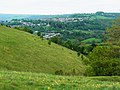
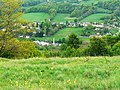
Rodborough Common is sited south of Stroud and has been owned and managed by the National Trust since 1937.[5] It is north of Minchinhampton Common. It lies on Jurassic limestone and is on top of the Cotswold scarp. It is bounded on either side by the Nailsworth valley and the Frome valley. It is on a hill (a plateau area), and its margins are dissected by dry valleys. The sides of this plateau are steep.[1]
Rodborough Common, like Minchinhampton Common, is notified for its biological and geological importance. The grassland is unimproved, herb-rich and calcareous. There is an important geological area for fossils for research purposes.[1]
Geology
There are old quarry workings which are near Rodborough Fort. These contain exposures of Inferior Oolite limestones of the Middle Jurassic Period. The fossils are numerous in the strata, and provide many species. Of particular interest are bivalve molluscs, and these were first defined from specimens collected on this site. The site is particularly significant as it is the only remaining one in the region. It is close to the southern edge of the Middle Inferior Oolite. This is cut out beneath the overlying Upper Trigonia Grit (across the common and to the south). In research terms this shows the effects of earth movements on the local succession.[1]
Biology
Flora
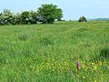
The grassland plateau supports tor-grass, upright brome, sheep's fescue and quaking grass. This area is relatively short as it is grazed and there is recreational use. The slopes support a higher sward and this is the area for insect life. Herbs recorded include chalk milkwort, clustered bellflower, kidney vetch and autumn gentian. There are several species of orchid which include frog orchid, bee orchid and musk orchid. The rare pasqueflower is recorded at this site.[1]
Scrub is scattered over the Common and near the edges. This include hawthorn, bramble and there are various types of small trees. Juniper is present. Where there is broad-leaved woodland, this is mainly beech and ash.[1]
Fauna
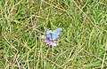
Invertebrates flourish on this site and butterflies recorded include the Duke of Burgundy and marsh fritillary. There are bugs, beetles and moths recorded. The snail Abida secale is present.[1] In 2019 a project to reintroduce the endangered Large blue to the common was undertaken with an estimated 750 butterflies emerging in the summer of 2020.[6]
References
- ^ a b c d e f g Natural England SSSI information on the citation
- ^ Stroud District Local Plan, adopted November 2005, Appendix 6 ‘Sites of Nature Conservation Interest’ Archived 2012-06-06 at the Wayback Machine
- ^ Information on Rodborough Common Special Area of Conservation designation.
- ^ Joint Nature Conservation Committee Listing of Special Areas of Conservation
- ^ "Warning: Cows coming out | Stroud Times". 10 May 2024. Retrieved 15 July 2024.
- ^ "'Extinct' large blue butterfly reintroduced to common". BBC. Retrieved 13 August 2020.
SSSI Source
- Natural England SSSI information on the citation
- Natural England SSSI information on the Rodborough Common units
External links
- Natural England (SSSI information)
- National Trust
-
 Rodborough Common
 -
 Rodborough Common
 -
 Rodborough Common flowering
 -
 Rodborough Common flowering
 -
 Butterfly on Rodborough Common
 -
 Green winged orchid on Rodborough Common
 -
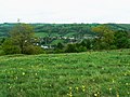
 View to Stroud
 -
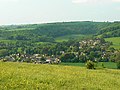
 View to Frome Valley
 -
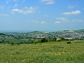
 View facing east
 -
 A west view
 -
 A north view
 -
 Northern extent
 -
 View to south-west
 -
 View to south-west
 -
 A view looking north west to Forest of Dean
 -
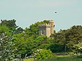 Rodborough Fort
 -
 Rodborough Common showing Fort


- v
- t
- e
- Ashleworth Ham
- Astridge Wood
- Badgeworth
- Barnsley Warren
- Barton Bushes
- Bigsweir Woods
- Blaisdon Hall
- Bourton Down
- Box Farm Meadows
- Boxwell
- Brassey
- Brooks Head Grove
- Buckshraft Mine & Bradley Railway Tunnel
- Bull Cross, The Frith and Juniper Hill
- Bushley Muzzard, Brimpsfield
- Caerwood and Ashberry Goose House
- Chaceley Meadow
- Clarke's Pool Meadow
- Cleeve Common
- Cockleford Marsh
- Collinpark Wood
- Coombe Hill Canal
- Coombe Hill
- Cotswold Commons and Beechwoods
- Cotswold Water Park
- Crickley Hill and Barrow Wake
- Daneway Banks
- Dean Hall Coach House & Cellar
- Devil's Chapel Scowles
- Dingle Wood
- Dixton Wood
- Dymock Woods
- Edge Common
- Elmlea Meadows
- Frampton Pools
- Highbury Wood
- Hobbs Quarry
- Hornsleasow Roughs
- Hucclecote Meadows
- Innsworth Meadow
- Juniper Hill, Edgeworth
- Kempley Daffodil Meadow
- Kingscote and Horsley Woods
- Lark Wood
- Leckhampton Hill and Charlton Kings Common
- Lineover Wood
- Lower Woods
- Lower Wye Gorge
- May Hill
- Midger
- Minchinhampton Common
- Nagshead
- Old Bow and Old Ham Mines
- Old River Severn, Upper Lode
- Pennsylvania Fields, Sedbury
- Poor's Allotment
- Puckham Woods
- Range Farm Fields
- River Wye
- Rodborough Common
- Rough Bank, Miserden
- Salmonsbury Meadows
- Selsley Common
- Severn Estuary
- Severn Ham, Tewkesbury
- Shorn Cliff and Caswell Woods
- Slade Brook
- Soudley Ponds
- Speech House Oaks
- Stenders Quarry
- Stinchcombe Hill
- Strawberry Banks
- Swanpool Wood and Furnace Grove
- Swift's Hill
- Sylvan House Barn
- The Hudnalls
- The Malvern Hills
- Tudor Farm Bank
- Turvey's Piece
- Upper Severn Estuary
- Upham Meadow and Summer Leasow
- Upper Wye Gorge
- Walmore Common
- Westbury Brook Ironstone Mine
- Whelford Meadow
- Wigpool Ironstone Mine
- Wildmoorway Meadows
- Winson Meadows
- Woodchester Park
- Workman's Wood
- Wotton Hill
- Yarley Meadows
- Neighbouring areas
- Avon
- Herefordshire
- Oxfordshire
- Wiltshire
- Worcestershire


