Ramón Castilla District
District in Loreto, Peru
Ramón Castilla | |
|---|---|
District | |
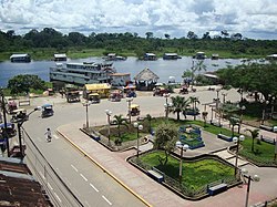 Caballococha | |
| Country |  Peru Peru |
| Region | Loreto |
| Province | Mariscal Ramón Castilla |
| Founded | July 2, 1943 |
| Capital | Caballococha |
| Area | |
| • Total | 7,122.78 km2 (2,750.12 sq mi) |
| Elevation | 84 m (276 ft) |
| Population (2005 census) | |
| • Total | 18,146 |
| • Density | 2.5/km2 (6.6/sq mi) |
| Time zone | UTC-5 (PET) |
| UBIGEO | 160401 |
Ramón Castilla District is one of four districts of the province Mariscal Ramón Castilla in Peru.[1] The district was named after Ramón Castilla.
Climate
| Climate data for Caballococha, Ramón Castilla, elevation 75 m (246 ft), (1991–2020) | |||||||||||||
|---|---|---|---|---|---|---|---|---|---|---|---|---|---|
| Month | Jan | Feb | Mar | Apr | May | Jun | Jul | Aug | Sep | Oct | Nov | Dec | Year |
| Mean daily maximum °C (°F) | 31.8 (89.2) | 31.8 (89.2) | 31.9 (89.4) | 31.9 (89.4) | 31.4 (88.5) | 31.2 (88.2) | 31.3 (88.3) | 32.3 (90.1) | 33.0 (91.4) | 32.7 (90.9) | 32.8 (91.0) | 32.0 (89.6) | 32.0 (89.6) |
| Mean daily minimum °C (°F) | 23.0 (73.4) | 23.1 (73.6) | 23.0 (73.4) | 23.2 (73.8) | 23.0 (73.4) | 22.4 (72.3) | 22.0 (71.6) | 22.2 (72.0) | 22.6 (72.7) | 23.0 (73.4) | 23.2 (73.8) | 23.2 (73.8) | 22.8 (73.1) |
| Average precipitation mm (inches) | 298.9 (11.77) | 297.8 (11.72) | 348.3 (13.71) | 358.1 (14.10) | 238.4 (9.39) | 172.1 (6.78) | 148.0 (5.83) | 110.6 (4.35) | 115.9 (4.56) | 219.6 (8.65) | 222.1 (8.74) | 283.4 (11.16) | 2,813.2 (110.76) |
| Source: National Meteorology and Hydrology Service of Peru[2] | |||||||||||||
References
- ^ (in Spanish) Instituto Nacional de Estadística e Informática. Banco de Información Distrital Archived 2008-04-23 at the Wayback Machine. Retrieved April 11, 2008.
- ^ "Normales Climáticas Estándares y Medias 1991-2020". National Meteorology and Hydrology Service of Peru. Archived from the original on 21 August 2023. Retrieved 17 June 2024.
External links
- Map of Ramón Castilla District[permanent dead link] El Instituto Nacional de Estadística e Informática (INEI)
- v
- t
- e

- Districts of Loreto Region
- Peru

3°54′36″S 70°31′30″W / 3.9100°S 70.5250°W / -3.9100; -70.5250
 | This Loreto Region geography article is a stub. You can help Wikipedia by expanding it. |
- v
- t
- e


