Prežba
42°46′20″N 16°48′34″E / 42.77222°N 16.80944°E / 42.77222; 16.80944Archipelago Lastovo Area 2.81 km2 (1.08 sq mi) Highest elevation 136 m (446 ft) Administration County Dubrovnik-Neretva > 100 km2 10–100 km2 1–10 km2
Croatia
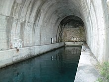
Prežba is a small inhabited island in the Croatian part of the Adriatic Sea, located northwest of the island of Lastovo in southern Dalmatia. It is connected to Lastovo by a bridge at the village of Pasadur on Lastovo. Prežba's area is 2.81 km2,[1] but its coastline is 14.23 km long, due to the large number of coves on the island. Its highest peak is 136 m above sea level and there is a lighthouse on the south side of the island, across the bay from Ubli. The island was used by the Yugoslav People's Army as a military base containing a tunnel and tunnel for ships.
See also
References
- ^ Duplančić Leder, Tea; Ujević, Tin; Čala, Mendi (June 2004). "Coastline lengths and areas of islands in the Croatian part of the Adriatic Sea determined from the topographic maps at the scale of 1 : 25 000" (PDF). Geoadria. 9 (1). Zadar: 5–32. doi:10.15291/geoadria.127. Retrieved 2019-12-26.
- v
- t
- e
Adriatic islands of Croatia
- Lists: Complete list
- Inhabited islands
- Arta Velika
- Biševo
- Dolin
- Drvenik Mali
- Goli Otok
- Ilovik
- Ist
- Jakljan
- Kakan
- Kaprije
- Katina
- Koločep
- Kurba Vela
- Lavdara
- Lavsa
- Levrnaka
- Lopud
- Mali Brijun
- Maun
- Mrčara
- Piškera
- Planik
- Plavnik
- Premuda
- Prežba
- Prvić (Šibenik)
- Rava
- Rivanj
- Šćedro
- Sit
- Smokvica Vela (Kornat)
- Škarda
- Škrda
- Sušac
- Susak
- Svetac
- Sveti Grgur
- Sveti Klement
- Tijat
- Tun Veli
- Vele Orjule
- Vele Srakane
- Veliki Brijun
- Vrgada
- Zeča
- Zlarin
- Zmajan
- Zverinac
This Dubrovnik-Neretva County geography article is a stub. You can help Wikipedia by expanding it. |
- v
- t
- e