Pescocostanzo
Comune in Abruzzo, Italy
Location of Pescocostanzo

41°53′14″N 14°3′59″E / 41.88722°N 14.06639°E / 41.88722; 14.06639
(1 January 2007)[2]
67033
Pescocostanzo is a comune and town of 1038 inhabitants in the Province of L'Aquila in the Abruzzo region of Italy. It is a tourist destination, attracting people from all over Italy due to its landscape and environment.[citation needed] It is part of the Maiella National Park and is one of I Borghi più belli d'Italia ("The most beautiful villages of Italy").[3] In winter, Pescocostanzo is a destination for skiers and snowboarders, and has its own ski resort. The towns of Roccaraso and Rivisondoli are close by.
Images
-
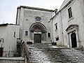 Basilica della Madonna del Colle
 -
 Palazzo Fanzago


See also
References
External links
Wikimedia Commons has media related to Pescocostanzo.
- I Borghi più belli d'Italia (it / en)
- Pescocostanzo Portal (it)
- Abruzzo Ski World Cup (it)
- (it)
- v
- t
- e
- Acciano
- Aielli
- Alfedena
- Anversa degli Abruzzi
- Ateleta
- Avezzano
- Balsorano
- Barete
- Barisciano
- Barrea
- Bisegna
- Bugnara
- Cagnano Amiterno
- Calascio
- Campo di Giove
- Campotosto
- Canistro
- Cansano
- Capestrano
- Capistrello
- Capitignano
- Caporciano
- Cappadocia
- Carapelle Calvisio
- Carsoli
- Castel del Monte
- Castel di Ieri
- Castel di Sangro
- Castellafiume
- Castelvecchio Calvisio
- Castelvecchio Subequo
- Celano
- Cerchio
- Civita d'Antino
- Civitella Alfedena
- Civitella Roveto
- Cocullo
- Collarmele
- Collelongo
- Collepietro
- Corfinio
- Fagnano Alto
- Fontecchio
- Fossa
- Gagliano Aterno
- Gioia dei Marsi
- Goriano Sicoli
- Introdacqua
- L'Aquila
- Lecce nei Marsi
- Luco dei Marsi
- Lucoli
- Magliano de' Marsi
- Massa d'Albe
- Molina Aterno
- Montereale
- Morino
- Navelli
- Ocre
- Ofena
- Opi
- Oricola
- Ortona dei Marsi
- Ortucchio
- Ovindoli
- Pacentro
- Pereto
- Pescasseroli
- Pescina
- Pescocostanzo
- Pettorano sul Gizio
- Pizzoli
- Poggio Picenze
- Prata d'Ansidonia
- Pratola Peligna
- Prezza
- Raiano
- Rivisondoli
- Rocca Pia
- Rocca di Botte
- Rocca di Cambio
- Rocca di Mezzo
- Roccacasale
- Roccaraso
- San Benedetto dei Marsi
- San Benedetto in Perillis
- San Demetrio ne' Vestini
- San Pio delle Camere
- San Vincenzo Valle Roveto
- Sant'Eusanio Forconese
- Sante Marie
- Santo Stefano di Sessanio
- Scanno
- Scontrone
- Scoppito
- Scurcola Marsicana
- Secinaro
- Sulmona
- Tagliacozzo
- Tione degli Abruzzi
- Tornimparte
- Trasacco
- Villa Sant'Angelo
- Villa Santa Lucia degli Abruzzi
- Villalago
- Villavallelonga
- Villetta Barrea
- Vittorito
| Authority control databases |
|
|---|
 | This Abruzzo location article is a stub. You can help Wikipedia by expanding it. |
- v
- t
- e


