Oudendijk, North Holland
Village in North Holland, Netherlands
52°36′N 4°58′E / 52.600°N 4.967°E / 52.600; 4.967[1]
[2]
(2021)[1]
1631[1]
Oudendijk is a village in the Dutch province of North Holland. It is a part of the municipality of Koggenland, and lies about 9 km (5.6 mi) southwest of Hoorn.
History
The village was first mentioned in 1423 or 1424 as "binnen den Ban van Oudendyc", and means "old dike".[3] Oudendijk developed along the dike in the 12th century. During the 13th century, the peat around to the north was excavated.[4]
The Dutch Reformed church is a single aisled church with ridge turret which was built in 1649 to replace a 15th century church.[4]
Oudendijk was home to 346 people in 1840.[5] It was a separate municipality between 1817 and 1979, when the new municipality of Wester-Koggenland was created.[6] In 2007, it became part of the municipality of Koggenland.[5]
Gallery
-
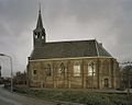 Dutch Reformed church

References
- ^ a b c "Kerncijfers wijken en buurten 2021". Central Bureau of Statistics. Retrieved 30 April 2022.
- ^ "Postcodetool for 1631DB". Actueel Hoogtebestand Nederland (in Dutch). Het Waterschapshuis. Retrieved 30 April 2022.
- ^ "Oudendijk - (geografische naam)". Etymologiebank (in Dutch). Retrieved 30 April 2022.
- ^ a b Ronald Stenvert & Saskia van Ginkel-Meester (2006). "Oudendijk" (in Dutch). Zwolle: Waanders. Retrieved 30 April 2022.
- ^ a b "Oudendijk". Plaatsengids (in Dutch). Retrieved 30 April 2022.
- ^ Ad van der Meer and Onno Boonstra, Repertorium van Nederlandse gemeenten, KNAW, 2011.
- v
- t
- e
Populated places in the municipality of Koggenland
- Avenhorn
- Berkhout
- De Goorn
- Grosthuizen
- Hensbroek
- Obdam
- Oudendijk
- Rustenburg
- Scharwoude
- Spierdijk
- Ursem (partially)
- Wogmeer [nl]
- Zuidermeer
 | This North Holland location article is a stub. You can help Wikipedia by expanding it. |
- v
- t
- e


