Otterspool railway station
Former railway station in England
53°22′07″N 2°56′07″W / 53.3685°N 2.9353°W / 53.3685; -2.9353
Cheshire Lines Committee | ||||||||||||||||||||||||||||||||||||||||||||||||||||||||||||||||||||||||||||||||||||||||||||||||||||||||||||||||||||||||||||||||||||||||||||||||||||||||||||||||||||||||||||||||||||||||||||||||||||||||||||||||||||||||||||||||||||||||||||||||||||||||||||||||||||||||||||||||||||||||||||||||||||||||||||||||||||||||||||||||||||||||||||||||||||||||||||||||||||||||||||||||||||||||||||||||||||||||||||||||||||||||
|---|---|---|---|---|---|---|---|---|---|---|---|---|---|---|---|---|---|---|---|---|---|---|---|---|---|---|---|---|---|---|---|---|---|---|---|---|---|---|---|---|---|---|---|---|---|---|---|---|---|---|---|---|---|---|---|---|---|---|---|---|---|---|---|---|---|---|---|---|---|---|---|---|---|---|---|---|---|---|---|---|---|---|---|---|---|---|---|---|---|---|---|---|---|---|---|---|---|---|---|---|---|---|---|---|---|---|---|---|---|---|---|---|---|---|---|---|---|---|---|---|---|---|---|---|---|---|---|---|---|---|---|---|---|---|---|---|---|---|---|---|---|---|---|---|---|---|---|---|---|---|---|---|---|---|---|---|---|---|---|---|---|---|---|---|---|---|---|---|---|---|---|---|---|---|---|---|---|---|---|---|---|---|---|---|---|---|---|---|---|---|---|---|---|---|---|---|---|---|---|---|---|---|---|---|---|---|---|---|---|---|---|---|---|---|---|---|---|---|---|---|---|---|---|---|---|---|---|---|---|---|---|---|---|---|---|---|---|---|---|---|---|---|---|---|---|---|---|---|---|---|---|---|---|---|---|---|---|---|---|---|---|---|---|---|---|---|---|---|---|---|---|---|---|---|---|---|---|---|---|---|---|---|---|---|---|---|---|---|---|---|---|---|---|---|---|---|---|---|---|---|---|---|---|---|---|---|---|---|---|---|---|---|---|---|---|---|---|---|---|---|---|---|---|---|---|---|---|---|---|---|---|---|---|---|---|---|---|---|---|---|---|---|---|---|---|---|---|---|---|---|---|---|---|---|---|---|---|---|---|---|---|---|---|---|---|---|---|---|---|---|---|---|---|---|---|---|---|---|---|---|---|---|---|---|---|---|---|---|---|---|---|---|---|---|---|---|---|---|---|---|---|---|---|---|---|---|---|---|
Legend | ||||||||||||||||||||||||||||||||||||||||||||||||||||||||||||||||||||||||||||||||||||||||||||||||||||||||||||||||||||||||||||||||||||||||||||||||||||||||||||||||||||||||||||||||||||||||||||||||||||||||||||||||||||||||||||||||||||||||||||||||||||||||||||||||||||||||||||||||||||||||||||||||||||||||||||||||||||||||||||||||||||||||||||||||||||||||||||||||||||||||||||||||||||||||||||||||||||||||||||||||||||||||
Merseyside Lines | ||||||||||||||||||||||||||||||||||||||||||||||||||||||||||||||||||||||||||||||||||||||||||||||||||||||||||||||||||||||||||||||||||||||||||||||||||||||||||||||||||||||||||||||||||||||||||||||||||||||||||||||||||||||||||||||||||||||||||||||||||||||||||||||||||||||||||||||||||||||||||||||||||||||||||||||||||||||||||||||||||||||||||||||||||||||||||||||||||||||||||||||||||||||||||||||||||||||||||||||||||||||||
| ||||||||||||||||||||||||||||||||||||||||||||||||||||||||||||||||||||||||||||||||||||||||||||||||||||||||||||||||||||||||||||||||||||||||||||||||||||||||||||||||||||||||||||||||||||||||||||||||||||||||||||||||||||||||||||||||||||||||||||||||||||||||||||||||||||||||||||||||||||||||||||||||||||||||||||||||||||||||||||||||||||||||||||||||||||||||||||||||||||||||||||||||||||||||||||||||||||||||||||||||||||||||


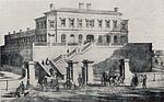
Otterspool station was a railway station in Liverpool, England. It was located between St Michaels and Aigburth stations on the Garston and Liverpool Railway.
The station opened in 1864 and was absorbed into the Cheshire Lines Committee in 1865. It closed in 1951 due to low passenger numbers. The station was at the end of a long and otherwise empty dirt lane which runs alongside Otterspool Park from Jericho Lane. The lane and the station building still exist, but the main building is now a private dwelling, with a subsidiary building beside it lying derelict. Whatever may remain of the platforms cannot be seen under vegetation.
References
- ^ a b c "Station Name: Otterspool". Disused Stations. Retrieved 28 February 2016.
- ^ Linsley 2000, p. 160.
- ^ Gell 1985, p.29 & Front Cover.
Sources
- Gell, Rob (1985). An Illustrated Survey of Liverpool's Railway Stations 1830-1985. Crosby, Merseyside: Heyday Publishing. ISBN 978-0-947562-03-8.
- Linsley, Robin (2000). Railways in camera : archive photographs of the great age of steam from the Public Record Office : 1860-1913. Stroud: Sutton Publishing. ISBN 978-1-84015-109-1.
External links
- The station's history Disused Stations
- The station and local lines on multiple maps Rail Maps Online
- The station on a 25" Edwardian OS Map National Library of Scotland
- The station on line HXS1, with mileages Railway Codes
| Preceding station | Historical railways | Following station | ||
|---|---|---|---|---|
| St Michaels Line and station open | Cheshire Lines Committee Garston and Liverpool Railway | Mersey Road and Aigburth Line and station open | ||


 | This article on a railway station in Merseyside is a stub. You can help Wikipedia by expanding it. |
- v
- t
- e


