Nightcap Range

Nightcap Range
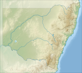
Location of the Nightcap Range in New South Wales

The Nightcap Range is a mountain range located in the Northern Rivers region of New South Wales, Australia, in the area between Lismore and the New South Wales-Queensland border. It includes Mount Burrell and Mount Nardi as well as containing the Nightcap National Park. The range is mainly covered with relict warm temperate rainforest and contains several rare and/or endemic species, most notably the Nightcap oak and the Minyon quandong.
Description
The range is a spur off the Great Dividing Range and extends generally southeast from Mount Burrell for about 25 kilometres (16 mi) to Peates Mountain.[3] It is separated from the remainder of the Great Dividing Range by the Nimbin Gap. The Range forms the southern flank of the Mount Warning (Tweed) shield volcano and geologically, is formed from the Lismore Basalts which are then overlain successively by the Nimbin Rhyolites and finally the Blue Knob Basalts.[4][5]
The highest peak in the range is Mount Burrell at 933 metres (3,061 ft) above sea level.[1] Other major peaks are Mount Neville at 919 metres (3,015 ft), Mount Nardi at 812 metres (2,664 ft), Mount Matheson at 804 metres (2,638 ft), and Peates Mountain at 604 metres (1,982 ft).[1] The name "Blue Knob" is applied to a prominence on the top of Mount Burrell (with "Sphinx Rock" another geological feature adjacent to the main elevated section); the names "Blue Knob" and "Mount Burrell" are also used for the names of settled areas (districts) at the base of the range.[6][7]
Man made features
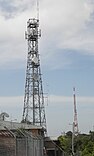
The summit of Mount Nardi is the site for several transmission towers which are used for FM radio, digital television and formerly, analogue TV and fixed wireless broadband internet transmissions,[8][9][10] as well as some mobile phone services. The summit can be reached by a bitumen road via Nimbin which cost £32,000 to construct in tandem with the first tower in 1962 (the tower itself costing only £10,000[11]) and is the starting point for several walking tracks including the Historic Nightcap walking track, which once was the principal route taken by travellers and postal workers between Lismore and Murwillumbah.[12]
The range contains the Nightcap National Park[13] and forms part of the catchment for Rocky Creek Dam which is located to the north of Lismore, and provides the drinking water supply for a large portion of the Northern Rivers area.
Notable flora

The range is the only known locality for the Nightcap oak, Eidothea hardeniana, a member of the Proteaceae, with a known population only around 100 wild plants, recognised and named in 2002.[14] Much of its habitat was devastated by a bushfire on the range (the Mount Nardi bushfire) in November 2019.[15] The range is also notable for containing the majority of known sites for the extremely restricted Minyon quandong, a medium sized tree in the Elaeocarpaceae, which had been recognised as a distinct species for some time but formally described only in 2008.[16]
Derivation of locality names
According to the Richmond-Tweed Regional Library's "Place Names of the Tweed, Brunswick and Upper Richmond Regions", the name "Nightcap" is a corruption of "night camp", as used by the original surveyors of the range and subsequent travellers; beyond Nimbin, further along the old Murwillumbah to Lismore route through the mountains, the small settlement of Coffee Camp retains its original, similarly derived name unaltered. Mount Matheson is named for the Government Surveyor George Matheson who, with his assistant Arthur Gracie, surveyed the track over the Nightcap Range in the early 1870s. Mount Burrell (stated as originally spelled with a single "l") is possibly from the Aboriginal word "burrul", meaning "wallaby", while Mount Nardi (previously considered a portion of Mount Matheson) is named for Terania Shire Councillor Angelo Nardi who served from 1956 to 1961.[17]
Gallery
-
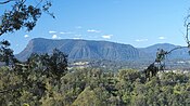 Distant view of Mount Burrell, the westernmost portion of the Nightcap Range
 -
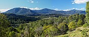 The Nightcap Range in NSW, Australia, distant view from south-west
 -
 Telephoto view of the three transmission towers on Mount Nardi
 -
 Close-up view of the Mount Nardi transmission towers; from the front: the ABRN6 digital TV tower; the central tower (Telstra-2); the NRN8 (originally: RTN-8) original analogue TV tower
 -
 Sunrise over the summit of Mount Nardi from the south, showing the radio and digital television transmission towers
 -
 Communications towers on Mount Nardi, New South Wales, Australia: the ABRN-6 tower (digital TV + more)
 -
 Communications towers on Mount Nardi, New South Wales, Australia: the central tower (Telstra-2)
 -
 Communications towers on Mount Nardi, New South Wales, Australia: the central tower (Telstra-2) - detail
 -
 Communications towers on Mount Nardi, New South Wales, Australia: the NRN8 (originally: RTN-8) tower (former analogue TV + other current uses)
 -
 Protesters Falls
 -
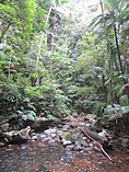 Rainforest at Protesters Falls, Nightcap NP
 -
 Rainbow through Minyon Falls
 -
 View at Minyon Falls, Nightcap NP


See also
 New South Wales portal
 Mountains portal


References
- ^ a b c "The Nightcap Range". The Hamlet of Rosebank. Archived from the original on 18 May 2015. Retrieved 10 May 2015.
- ^ "Mount Burrell". Geographical Names Register (GNR) of NSW. Geographical Names Board of New South Wales. Retrieved 10 May 2015.

- ^ a b "Nightcap Range". Geographical Names Register (GNR) of NSW. Geographical Names Board of New South Wales. Retrieved 10 May 2015.
- ^ Big Volcano (Wollumbin) Visitor Guide: National Parks of the Tweed Volcano Region Archived 2020-02-02 at the Wayback Machine
- ^ Big Volcano (Wollumbin) Visitor Guide: The Lost World - Records in the Rocks Archived 2013-03-14 at the Wayback Machine
- ^ 2016 Census QuickStats: Blue Knob
- ^ 2016 Census QuickStats: Mount Burrell
- ^ "Mount Nardi FM transmitter info". fmscan.org. Retrieved 4 August 2019.
- ^ "Mt Nardi Digital TV Broadcast Site". ozdigitaltv.com. Archived from the original on 4 August 2019. Retrieved 4 August 2019.
- ^ "Offline: Northern Rivers telco Linknet powers down Mt Nardi service". ABC North Coast NSW. 9 December 2014. Archived from the original on 31 July 2016. Retrieved 4 August 2019.
- ^ trove.nla.gov.au: The Australian Women's Weekly (1933 - 1982) Wed 16 May 1962 Page 4: Country men solved problem that beat world experts
- ^ "Visit NSW: Historic Nightcap Walking Track". Archived from the original on 2019-12-16. Retrieved 2019-12-16.
- ^ "Map of Nightcap Range, NSW". Bonzle Digital Atlas of Australia. Retrieved 10 May 2015.
- ^ Weston, P. H.; Kooyman, R. M. (2002). "Systematics of Eidothea (Proteaceae), with the description of a new species, E. hardeniana, from the Nightcap Range, north-eastern New South Wales". Telopea. 9 (4): 821–832. doi:10.7751/telopea20024022.
- ^ Shoebridge, Joanne; Marciniak, Catherine (18 January 2020). "Gondwana-era rainforest stand of nightcap oak devastated by unprecedented bushfire". ABC News. Australian Broadcasting Corporation. Retrieved 18 January 2020.
- ^ Maynard, David; Crayn, Darren; Rossetto, Marco; Kooyman, Robert; Coode, Mark (2008). "Elaeocarpus sedentarius sp. nov. (Elaeocarpaceae)—morphometric analysis of a new, rare species from eastern Australia". Australian Systematic Botany. 21 (3). pp. 192–200 (196–199), Figs 3, 4. doi:10.1071/SB07031.
- ^ Richmond-Tweed Regional Library (1984). Place Names of the Tweed, Brunswick and Upper Richmond Regions.
External links
- www.echo.net.au: Area burned in the November 2019 Mount Nardi bushfire, as at 18 November 2019 (original article here)
- v
- t
- e
(not part of the
Great Dividing Range)
| Mid North Coast |
|
|---|---|
| Allyn, Barrington & Mount Royal |
|
| Gibraltar and Sugarloaf |
|
| Blue Mountains |
|
| Illawarra |
|
| The Budawangs |
|
| Tweed | |||||
|---|---|---|---|---|---|
| McPherson and Nightcap | |||||
| Mid North Coast |
| ||||
| Nandewar |
| ||||
| Liverpool and Watagan |
| ||||
| New England and Moonbi |
| ||||
| Central Tablelands |
| ||||
| The Brindabellas and Scabby |
| ||||
| Monaro |
| ||||
| Snowies |
| ||||
| Other mountains in the GDR |
|
| Barrier |
|
|---|---|
| Warrumbungles |
|
| Other inland mountains |
| Lord Howe |
|---|
a specific range


