National Register of Historic Places listings in Bibb County, Alabama

This is a list of the National Register of Historic Places listings in Bibb County, Alabama.
This is intended to be a complete list of the properties and districts on the National Register of Historic Places in Bibb County, Alabama, United States. Latitude and longitude coordinates are provided for many National Register properties and districts; these locations may be seen together in a Google map.[1]
There are 6 properties and districts listed on the National Register in the county.
This National Park Service list is complete through NPS recent listings posted June 7, 2024.[2]
Map all coordinates using OpenStreetMap
Download coordinates as:
- KML
- GPX (all coordinates)
- GPX (primary coordinates)
- GPX (secondary coordinates)
| [3] | Name on the Register | Image | Date listed[4] | Location | City or town | Description |
|---|---|---|---|---|---|---|
| 1 | Blocton Italian Catholic Cemetery | 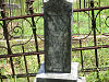 | April 22, 1999 (#99000464) | Primitive Ridge Rd. 33°06′46″N 87°06′49″W / 33.112778°N 87.113611°W / 33.112778; -87.113611 (Blocton Italian Catholic Cemetery) | West Blocton | |
| 2 | Brierfield Furnace |  | November 20, 1974 (#74000401) | West of Brierfield 33°02′41″N 86°55′45″W / 33.044722°N 86.929167°W / 33.044722; -86.929167 (Brierfield Furnace) | Brierfield | |
| 3 | Centreville Historic District |  | October 19, 1978 (#78000482) | Walnut St., East and West Court Sq. 32°56′41″N 87°08′13″W / 32.944722°N 87.136944°W / 32.944722; -87.136944 (Centreville Historic District) | Centreville | |
| 4 | Davidson-Smitherman House | 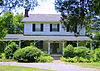 | January 6, 1988 (#87001552) | 167 3rd Ave. 32°56′34″N 87°08′01″W / 32.942778°N 87.133611°W / 32.942778; -87.133611 (Davidson-Smitherman House) | Centreville | |
| 5 | Sarah Amanda Trott McKinney House | 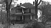 | May 29, 1992 (#92000626) | State Route 25 between Montevallo and Centreville 33°00′25″N 87°00′18″W / 33.006944°N 87.005°W / 33.006944; -87.005 (Sarah Amanda Trott McKinney House) | Sixmile | |
| 6 | Montebrier |  | April 2, 1973 (#73000331) | North of Brierfield on Mahan Creek 33°02′32″N 86°54′11″W / 33.042222°N 86.903056°W / 33.042222; -86.903056 (Montebrier) | Brierfield |
See also
Wikimedia Commons has media related to National Register of Historic Places in Bibb County, Alabama.
- List of National Historic Landmarks in Alabama
- National Register of Historic Places listings in Alabama
References
- ^ The latitude and longitude information provided in this table was derived originally from the National Register Information System, which has been found to be fairly accurate for about 99% of listings. Some locations in this table may have been corrected to current GPS standards.
- ^ National Park Service, United States Department of the Interior, "National Register of Historic Places: Weekly List Actions", retrieved June 7, 2024.
- ^ Numbers represent an alphabetical ordering by significant words. Various colorings, defined here, differentiate National Historic Landmarks and historic districts from other NRHP buildings, structures, sites or objects.
- ^ The eight-digit number below each date is the number assigned to each location in the National Register Information System database, which can be viewed by clicking the number.
- v
- t
- e
by county
- Autauga
- Baldwin
- Barbour
- Bibb
- Blount
- Bullock
- Butler
- Calhoun
- Chambers
- Cherokee
- Chilton
- Choctaw
- Clarke
- Clay
- Cleburne
- Coffee
- Colbert
- Conecuh
- Coosa
- Covington
- Crenshaw
- Cullman
- Dale
- Dallas
- DeKalb
- Elmore
- Escambia
- Etowah
- Fayette
- Franklin
- Geneva
- Greene
- Hale
- Henry
- Houston
- Jackson
- Jefferson
- Lamar
- Lauderdale
- Lawrence
- Lee
- Limestone
- Lowndes
- Macon
- Madison
- Marengo
- Marion
- Marshall
- Mobile
- Monroe
- Montgomery
- Morgan
- Perry
- Pickens
- Pike
- Randolph
- Russell
- St. Clair
- Shelby
- Sumter
- Talladega
- Tallapoosa
- Tuscaloosa
- Walker
- Washington
- Wilcox
- Winston

Municipalities and communities of Bibb County, Alabama, United States | ||
|---|---|---|
County seat: Centreville | ||
| Cities | 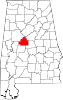 | |
| Towns | ||
| Unincorporated communities | ||
| Ghost town | ||
| Footnotes | ‡This populated place also has portions in an adjacent county or counties | |
| ||


