National Register of Historic Places listings in Bedford County, Tennessee

This is a list of the National Register of Historic Places listings in Bedford County, Tennessee.
This is intended to be a complete list of the properties and districts on the National Register of Historic Places in Bedford County, Tennessee, United States. Latitude and longitude coordinates are provided for many National Register properties and districts; these locations may be seen together in a map.[1]
There are 32 properties and districts listed on the National Register in the county. Two other properties were once listed, but have since been removed.
Map all coordinates using OpenStreetMap
Download coordinates as:
- KML
- GPX (all coordinates)
- GPX (primary coordinates)
- GPX (secondary coordinates)
| Anderson – Bedford – Benton – Bledsoe – Blount – Bradley – Campbell – Cannon – Carroll – Carter – Cheatham – Chester – Claiborne – Clay – Cocke – Coffee – Crockett – Cumberland – Davidson – Decatur – DeKalb – Dickson – Dyer – Fayette – Fentress – Franklin – Gibson – Giles – Grainger – Greene – Grundy – Hamblen – Hamilton – Hancock – Hardeman – Hardin – Hawkins – Haywood – Henderson – Henry – Hickman – Houston – Humphreys – Jackson – Jefferson – Johnson – Knox – Lake – Lauderdale – Lawrence – Lewis – Lincoln – Loudon – Macon – Madison – Marion – Marshall – Maury – McMinn – McNairy – Meigs – Monroe – Montgomery – Moore – Morgan – Obion – Overton – Perry – Pickett – Polk – Putnam – Rhea – Roane – Robertson – Rutherford – Scott – Sequatchie – Sevier – Shelby – Smith – Stewart – Sullivan – Sumner – Tipton – Trousdale – Unicoi – Union – Van Buren – Warren – Washington – Wayne – Weakley – White – Williamson – Wilson |
This National Park Service list is complete through NPS recent listings posted August 23, 2024.[2]
Current listings
| [3] | Name on the Register[4] | Image | Date listed[5] | Location | City or town | Description |
|---|---|---|---|---|---|---|
| 1 | Bedford County Jail |  | April 1, 1975 (#75001728) | N. Spring and Jackson Sts. 35°29′04″N 86°27′38″W / 35.484444°N 86.460556°W / 35.484444; -86.460556 (Bedford County Jail) | Shelbyville | |
| 2 | Bell Buckle Historic District |  | January 20, 1976 (#76001762) | Irregular pattern bounded roughly by Webb Rd., Abernathy, Maple, Cumberland, and Church Sts. 35°35′N 86°21′W / 35.59°N 86.35°W / 35.59; -86.35 (Bell Buckle Historic District) | Bell Buckle | Includes commercial blocks along Main and Webb constructed in the 1890s |
| 3 | Brame-Reed House | 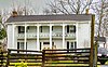 | January 23, 1998 (#97001671) | 1550 State Route 64, W. 35°27′21″N 86°32′39″W / 35.455833°N 86.544167°W / 35.455833; -86.544167 (Brame-Reed House) | Shelbyville | |
| 4 | Henry A. Clark House |  | August 30, 1985 (#85001899) | 4615 TN-64 35°32′32″N 86°19′44″W / 35.542222°N 86.328889°W / 35.542222; -86.328889 (Henry A. Clark House) | Wartrace | |
| 5 | Gov. Prentice Cooper House |  | June 5, 1975 (#75001729) | 413 E. Lane St. 35°29′06″N 86°27′12″W / 35.485°N 86.453333°W / 35.485; -86.453333 (Gov. Prentice Cooper House) | Shelbyville | |
| 6 | Spencer Eakin Farm |  | June 24, 1993 (#93000564) | 201 Nashville Dirt Rd. 35°30′32″N 86°28′16″W / 35.508889°N 86.471111°W / 35.508889; -86.471111 (Spencer Eakin Farm) | Shelbyville | |
| 7 | East Shelbyville Historic District | Upload image | April 23, 1990 (#90000594) | Bounded roughly by N. Brittian, former Louisville & Nashville railroad tracks, and Lane, Evans, Sandusky, and Madison Sts. 35°29′10″N 86°27′16″W / 35.486111°N 86.454444°W / 35.486111; -86.454444 (East Shelbyville Historic District) | Shelbyville | |
| 8 | Winston Evans House |  | November 27, 1989 (#89002026) | 306 E. Franklin St. 35°29′08″N 86°27′23″W / 35.485556°N 86.456389°W / 35.485556; -86.456389 (Winston Evans House) | Shelbyville | |
| 9 | Farrar Homeplace | 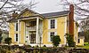 | November 7, 1990 (#90001657) | 170 Ike Farrar Rd. 35°21′37″N 86°23′24″W / 35.360278°N 86.39°W / 35.360278; -86.39 (Farrar Homeplace) | Shelbyville | |
| 10 | First Presbyterian Church |  | July 17, 1980 (#80003780) | 600 N. Brittain St. 35°29′10″N 86°27′29″W / 35.486111°N 86.458056°W / 35.486111; -86.458056 (First Presbyterian Church) | Shelbyville | |
| 11 | Fly Manufacturing Company Building |  | March 7, 1996 (#96000226) | 204 S. Main St. 35°28′53″N 86°27′42″W / 35.481389°N 86.461667°W / 35.481389; -86.461667 (Fly Manufacturing Company Building) | Shelbyville | |
| 12 | Frierson-Coble House |  | April 12, 1982 (#82003951) | 404 N. Jefferson St. 35°29′06″N 86°27′27″W / 35.485°N 86.4575°W / 35.485; -86.4575 (Frierson-Coble House) | Shelbyville | |
| 13 | James Gilliland House |  | May 12, 1975 (#75001730) | 803 Lipscomb St. 35°29′38″N 86°27′38″W / 35.493889°N 86.460556°W / 35.493889; -86.460556 (James Gilliland House) | Shelbyville | |
| 14 | Grassland Farm | 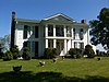 | March 4, 1975 (#75001731) | 8 miles southwest of Shelbyville on Snell Rd. 35°24′16″N 86°30′43″W / 35.404444°N 86.511944°W / 35.404444; -86.511944 (Grassland Farm) | Shelbyville | |
| 15 | Heidt Tavern-Singleton House |  | June 24, 1991 (#91000823) | 119 Clyde Gleaves Rd. 35°33′58″N 86°16′55″W / 35.566111°N 86.281944°W / 35.566111; -86.281944 (Heidt Tavern-Singleton House) | Wartrace | |
| 16 | Jenkins Lutheran Chapel and Cemetery |  | October 17, 1997 (#97001231) | 364 Shofner Bridge Rd. 35°27′47″N 86°22′49″W / 35.463056°N 86.380278°W / 35.463056; -86.380278 (Jenkins Lutheran Chapel and Cemetery) | Shelbyville | |
| 17 | Absalom Lowe Landis House |  | June 25, 1987 (#87001034) | Thompson's Creek Rd. 35°26′51″N 86°19′25″W / 35.4475°N 86.323611°W / 35.4475; -86.323611 (Absalom Lowe Landis House) | Normandy | |
| 18 | Maple Dean Farm | Upload image | March 30, 1995 (#95000269) | 400 New Herman Rd. 35°22′30″N 86°25′48″W / 35.375°N 86.43°W / 35.375; -86.43 (Maple Dean Farm) | Shelbyville | |
| 19 | Martin House |  | April 14, 1972 (#72001227) | 7 miles northeast of Wartrace off State Route 64 35°35′52″N 86°15′40″W / 35.597778°N 86.261111°W / 35.597778; -86.261111 (Martin House) | Wartrace | |
| 20 | Normandy Historic District | Upload image | November 7, 1985 (#85002786) | Roughly bounded by Maple and Poplar Sts., Tullahoma Rd., College St., and Old Manchester Rd. 35°27′06″N 86°15′34″W / 35.451667°N 86.259444°W / 35.451667; -86.259444 (Normandy Historic District) | Normandy | |
| 21 | Palmetto Farm |  | March 28, 1985 (#85000675) | 2935 Shelbyville Hwy. 35°29′28″N 86°39′49″W / 35.491111°N 86.663611°W / 35.491111; -86.663611 (Palmetto Farm) | Lewisburg | |
| 22 | Raus School | Upload image | November 21, 2012 (#12000966) | 125 Smith Chapel Rd. 35°23′38″N 86°19′51″W / 35.39398°N 86.33090°W / 35.39398; -86.33090 (Raus School) | Raus vicinity | |
| 23 | River Side Farmhouse | 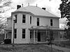 | December 1, 1997 (#97001501) | 497 Shofner Rd. 35°26′58″N 86°22′53″W / 35.449444°N 86.381389°W / 35.449444; -86.381389 (River Side Farmhouse) | Shelbyville | |
| 24 | Shelbyville Courthouse Square Historic District |  | October 27, 1982 (#82001725) | Public Square (Main, Spring, Depot, and Holland Sts.) 35°28′57″N 86°27′37″W / 35.4825°N 86.460278°W / 35.4825; -86.460278 (Shelbyville Courthouse Square Historic District) | Shelbyville | |
| 25 | Shelbyville Hydroelectric Station |  | February 9, 1990 (#89002354) | State Route 231 at the Duck River 35°29′08″N 86°28′01″W / 35.485556°N 86.466944°W / 35.485556; -86.466944 (Shelbyville Hydroelectric Station) | Shelbyville | |
| 26 | Shelbyville Railroad Station |  | March 24, 1988 (#88000265) | Depot St. 35°28′55″N 86°27′24″W / 35.481944°N 86.456667°W / 35.481944; -86.456667 (Shelbyville Railroad Station) | Shelbyville | |
| 27 | Shofners' Lutheran Church and Cemetery |  | July 10, 1998 (#97001232) | 2896 US-41A 35°26′48″N 86°19′46″W / 35.446667°N 86.329444°W / 35.446667; -86.329444 (Shofners' Lutheran Church and Cemetery) | Wartrace | |
| 28 | John Green Sims House |  | November 5, 1987 (#87001937) | 620 Knobs Creek Rd. 35°31′20″N 86°19′17″W / 35.522222°N 86.321389°W / 35.522222; -86.321389 (John Green Sims House) | Wartrace | |
| 29 | Thompson Creek Rural Historic District | Upload image | May 8, 2019 (#100003898) | Along sections of US 41-A, Normandy, Cathey, Thompson Creek & Shofner Rds., Hornaday Ln. & Three Forks Bridge 35°26′52″N 86°19′39″W / 35.4478°N 86.3275°W / 35.4478; -86.3275 (Thompson Creek Rural Historic District) | Wartrace | |
| 30 | Valley Home |  | November 13, 1989 (#89001956) | 310 Potts Rd. 35°31′49″N 86°18′47″W / 35.530278°N 86.313056°W / 35.530278; -86.313056 (Valley Home) | Wartrace | |
| 31 | Walking Horse Hotel |  | July 19, 1984 (#84003262) | Spring St. 35°31′38″N 86°20′04″W / 35.527222°N 86.334444°W / 35.527222; -86.334444 (Walking Horse Hotel) | Wartrace | Built in 1917; still operates as a hotel. |
| 32 | Wartrace Historic District |  | July 31, 1991 (#91000914) | Roughly Spring St. from Coffey to Main Sts., Vine St. from Broad to McKinley Sts. and Knob Creek Rd. from Main to McKinley 35°31′39″N 86°20′01″W / 35.5275°N 86.333611°W / 35.5275; -86.333611 (Wartrace Historic District) | Wartrace |
Former listings
| [3] | Name on the Register | Image | Date listed | Date removed | Location | City or town | Description |
|---|---|---|---|---|---|---|---|
| 1 | Bivvins House | Upload image | December 6, 1979 (#79002413) | March 10, 2009 | Off U.S. Route 41 35°30′07″N 86°28′18″W / 35.5019°N 86.4717°W / 35.5019; -86.4717 (Bivvins House) | Shelbyville | Destroyed by fire. |
| 2 | Webb School, Junior Room | Upload image | April 1, 1973 (#73001751) | October 20, 1987 | Off TN 82 35°35′18″N 86°20′54″W / 35.588209°N 86.34839°W / 35.588209; -86.34839 (Webb School, Junior Room) | Bell Buckle | Delisted after being relocated to another location on the campus of The Webb School. |
See also
Wikimedia Commons has media related to National Register of Historic Places in Bedford County, Tennessee.
- List of National Historic Landmarks in Tennessee
- National Register of Historic Places listings in Tennessee
References
- ^ The latitude and longitude information provided in this table was derived originally from the National Register Information System, which has been found to be fairly accurate for about 99% of listings. Some locations in this table may have been corrected to current GPS standards.
- ^ National Park Service, United States Department of the Interior, "National Register of Historic Places: Weekly List Actions", retrieved August 23, 2024.
- ^ a b Numbers represent an alphabetical ordering by significant words. Various colorings, defined here, differentiate National Historic Landmarks and historic districts from other NRHP buildings, structures, sites or objects.
- ^ "National Register Information System". National Register of Historic Places. National Park Service. April 24, 2008.
- ^ The eight-digit number below each date is the number assigned to each location in the National Register Information System database, which can be viewed by clicking the number.
- v
- t
- e
- List of U.S. National Historic Landmarks by state:
- Alabama
- Alaska
- Arizona
- Arkansas
- California
- Colorado
- Connecticut
- Delaware
- Florida
- Georgia
- Hawaii
- Idaho
- Illinois
- Indiana
- Iowa
- Kansas
- Kentucky
- Louisiana
- Maine
- Maryland
- Massachusetts
- Michigan
- Minnesota
- Mississippi
- Missouri
- Montana
- Nebraska
- Nevada
- New Hampshire
- New Jersey
- New Mexico
- New York
- North Carolina
- North Dakota
- Ohio
- Oklahoma
- Oregon
- Pennsylvania
- Rhode Island
- South Carolina
- South Dakota
- Tennessee
- Texas
- Utah
- Vermont
- Virginia
- Washington
- West Virginia
- Wisconsin
- Wyoming
 National Register of Historic Places portal
 Category


