National Register of Historic Places listings in Anderson County, Tennessee

This is a list of the National Register of Historic Places listings in Anderson County, Tennessee.
This is intended to be a complete list of the properties and districts on the National Register of Historic Places in Anderson County, Tennessee, United States. Latitude and longitude coordinates are provided for many National Register properties and districts; these locations may be seen together in a map.[1]
There are 20 properties and districts in the county that are listed on the National Register, and one former listing.
See also National Register of Historic Places listings in Roane County, Tennessee for additional properties in Oak Ridge and Oliver Springs, cities that span the county line.
Map all coordinates using OpenStreetMap
Download coordinates as:
- KML
- GPX (all coordinates)
- GPX (primary coordinates)
- GPX (secondary coordinates)
| Anderson – Bedford – Benton – Bledsoe – Blount – Bradley – Campbell – Cannon – Carroll – Carter – Cheatham – Chester – Claiborne – Clay – Cocke – Coffee – Crockett – Cumberland – Davidson – Decatur – DeKalb – Dickson – Dyer – Fayette – Fentress – Franklin – Gibson – Giles – Grainger – Greene – Grundy – Hamblen – Hamilton – Hancock – Hardeman – Hardin – Hawkins – Haywood – Henderson – Henry – Hickman – Houston – Humphreys – Jackson – Jefferson – Johnson – Knox – Lake – Lauderdale – Lawrence – Lewis – Lincoln – Loudon – Macon – Madison – Marion – Marshall – Maury – McMinn – McNairy – Meigs – Monroe – Montgomery – Moore – Morgan – Obion – Overton – Perry – Pickett – Polk – Putnam – Rhea – Roane – Robertson – Rutherford – Scott – Sequatchie – Sevier – Shelby – Smith – Stewart – Sullivan – Sumner – Tipton – Trousdale – Unicoi – Union – Van Buren – Warren – Washington – Wayne – Weakley – White – Williamson – Wilson |
This National Park Service list is complete through NPS recent listings posted August 30, 2024.[2]
Current listings
| [3] | Name on the Register[4] | Image | Date listed[5] | Location | City or town | Description |
|---|---|---|---|---|---|---|
| 1 | Arnwine Cabin |  | March 16, 1976 (#76001760) | State Route 61 36°10′53″N 84°04′10″W / 36.181389°N 84.069444°W / 36.181389; -84.069444 (Arnwine Cabin) | Norris | Part of the collection of the Museum of Appalachia |
| 2 | Bear Creek Road Checking Station | 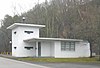 | May 6, 1992 (#92000411) | Junction of S. Illinois Ave. and Bear Creek Rd. 35°59′57″N 84°14′35″W / 35.999167°N 84.243056°W / 35.999167; -84.243056 (Bear Creek Road Checking Station) | Oak Ridge | |
| 3 | Bethel Valley Road Checking Station | 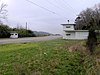 | May 6, 1992 (#92000410) | Junction of Bethel Valley and Scarboro Rds. 35°59′13″N 84°13′02″W / 35.986944°N 84.217222°W / 35.986944; -84.217222 (Bethel Valley Road Checking Station) | Oak Ridge | |
| 4 | Briceville Community Church and Cemetery |  | July 24, 2003 (#03000697) | State Route 116 36°10′43″N 84°10′59″W / 36.178611°N 84.183056°W / 36.178611; -84.183056 (Briceville Community Church and Cemetery) | Briceville | Rural Gothic Revival church, now primarily a community center |
| 5 | Cross - Boggs Place | Upload image | May 6, 2024 (#100010138) | 453 Oliver Springs Highway 36°04′05″N 84°12′45″W / 36.0680°N 84.2125°W / 36.0680; -84.2125 (Cross - Boggs Place) | Clinton | |
| 6 | Cross Mountain Miners' Circle |  | March 15, 2006 (#06000134) | Circle Cemetery Ln. 36°10′26″N 84°11′11″W / 36.173889°N 84.186389°W / 36.173889; -84.186389 (Cross Mountain Miners' Circle) | Briceville | |
| 7 | Daugherty Furniture Building |  | November 29, 2010 (#10000936) | 307 N. Main St. 36°06′09″N 84°07′55″W / 36.1025°N 84.131944°W / 36.1025; -84.131944 (Daugherty Furniture Building) | Clinton | |
| 8 | Edwards-Fowler House | Upload image | May 29, 1975 (#75001726) | 3½ miles south of Rocky Top on Dutch Valley Rd. 36°10′18″N 84°10′03″W / 36.171667°N 84.1675°W / 36.171667; -84.1675 (Edwards-Fowler House) | Rocky Top | |
| 9 | Fort Anderson on Militia Hill |  | November 21, 2011 (#11000830) | Vowell Mountain Rd. 36°12′56″N 84°10′32″W / 36.215633°N 84.175481°W / 36.215633; -84.175481 (Fort Anderson on Militia Hill) | Rocky Top | Site of the Tennessee state militia's garrison during the Coal Creek War of 1891 and 1892, when local coal miners and the state government battled over the use of convict labor in area coal mines. |
| 10 | Fraterville Miners' Circle Cemetery | 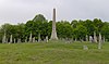 | January 5, 2005 (#04001459) | Leach Cemetery Lane 36°12′39″N 84°08′25″W / 36.210833°N 84.140278°W / 36.210833; -84.140278 (Fraterville Miners' Circle Cemetery) | Rocky Top | |
| 11 | Freels Cabin | 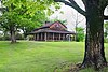 | May 6, 1992 (#92000407) | Freels Bend Rd. 35°57′48″N 84°13′25″W / 35.963333°N 84.223611°W / 35.963333; -84.223611 (Freels Cabin) | Oak Ridge | Also called "Freels Bend Cabin"; built in 1844, currently located on restricted federal property |
| 12 | J. B. Jones House | 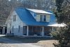 | September 5, 1991 (#19910905) | Old Edgemoor Road between Bethel Valley Road and Melton Hill Lake 36°00′33″N 84°10′09″W / 36.009167°N 84.169167°W / 36.009167; -84.169167 (J. B. Jones House) | Oak Ridge | |
| 13 | Green McAdoo School |  | November 8, 2005 (#05001218) | 101 School St. 36°06′16″N 84°08′24″W / 36.104444°N 84.14°W / 36.104444; -84.14 (Green McAdoo School) | Clinton | |
| 14 | Norris Dam State Park Rustic Cabins Historic District | 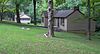 | July 25, 2014 (#14000446) | 125 Village Green Circle 36°13′32″N 84°05′10″W / 36.2256°N 84.0860°W / 36.2256; -84.0860 (Norris Dam State Park Rustic Cabins Historic District) | Rocky Top | |
| 15 | Norris District |  | July 10, 1975 (#75001727) | City of Norris on U.S. Route 441 36°11′47″N 84°04′08″W / 36.196389°N 84.068889°W / 36.196389; -84.068889 (Norris District) | Norris | |
| 16 | Norris Hydroelectric Project |  | April 12, 2016 (#16000165) | 300 Powerhouse Way 36°13′27″N 84°05′32″W / 36.224167°N 84.092222°W / 36.224167; -84.092222 (Norris Hydroelectric Project) | Norris | Extends into Campbell County |
| 17 | Oak Ridge Historic District | 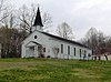 | September 5, 1991 (#91001109) | Roughly bounded by East Drive, West Outer Drive, Louisiana Avenue, and Tennessee Avenue 36°01′41″N 84°15′10″W / 36.028056°N 84.252778°W / 36.028056; -84.252778 (Oak Ridge Historic District) | Oak Ridge | Contributing properties in the historic district include United Church, The Chapel on the Hill, the Alexander Inn, and the elementary school now occupied by the Children's Museum of Oak Ridge. |
| 18 | Oliver Springs Banking Company |  | April 14, 1992 (#92000357) | 410 Main St. 36°02′43″N 84°20′23″W / 36.045278°N 84.339722°W / 36.045278; -84.339722 (Oliver Springs Banking Company) | Oliver Springs | |
| 19 | Ritz Theatre and Hoskins Rexall Drug Store No. 2 |  | December 4, 1998 (#98001446) | 111-121 N. Main St. 36°06′00″N 84°07′59″W / 36.1°N 84.133056°W / 36.1; -84.133056 (Ritz Theatre and Hoskins Rexall Drug Store No. 2) | Clinton | Hoskins Drug Store is a family-owned business that was established on Market Street in Clinton in 1930 by R.C. "Dudley" Hoskins. The Main Street location, which is part of the National Register listing, opened in 1947. At one time there were as many as 13 Hoskins stores in East Tennessee.[6] |
| 20 | Woodland-Scarboro Historic District |  | September 5, 1991 (#91001106) | Roughly bounded by Rutgers Avenue, Lafayette Drive, Benedict Avenue, Wilberforce Avenue, and Illinois Avenue 36°00′16″N 84°15′06″W / 36.004444°N 84.251667°W / 36.004444; -84.251667 (Woodland-Scarboro Historic District) | Oak Ridge |
Former listings
| [3] | Name on the Register | Image | Date listed | Date removed | Location | City or town | Description |
|---|---|---|---|---|---|---|---|
| 1 | Luther Brannon House |  | September 5, 1991 (#91001108) | October 28, 2021 | 151 Oak Ridge Turnpike 36°02′40″N 84°12′34″W / 36.044444°N 84.209444°W / 36.044444; -84.209444 (Luther Brannon House) | Oak Ridge | Demolished in 2021.[7] |
See also
Wikimedia Commons has media related to National Register of Historic Places in Anderson County, Tennessee.
- List of National Historic Landmarks in Tennessee
- National Register of Historic Places listings in Tennessee
References
- ^ The latitude and longitude information provided in this table was derived originally from the National Register Information System, which has been found to be fairly accurate for about 99% of listings. Some locations in this table may have been corrected to current GPS standards.
- ^ National Park Service, United States Department of the Interior, "National Register of Historic Places: Weekly List Actions", retrieved August 30, 2024.
- ^ a b Numbers represent an alphabetical ordering by significant words. Various colorings, defined here, differentiate National Historic Landmarks and historic districts from other NRHP buildings, structures, sites or objects.
- ^ "National Register Information System". National Register of Historic Places. National Park Service. April 24, 2008.
- ^ The eight-digit number below each date is the number assigned to each location in the National Register Information System database, which can be viewed by clicking the number.
- ^ Clayton Hensley, Hoskins stores celebrate 80th anniversary; Pharmacy carries everything from gifts to soda fountain, Knoxville News Sentinel, April 29, 2010
- ^ "Controversy over demolition of stone house".
- v
- t
- e
- List of U.S. National Historic Landmarks by state:
- Alabama
- Alaska
- Arizona
- Arkansas
- California
- Colorado
- Connecticut
- Delaware
- Florida
- Georgia
- Hawaii
- Idaho
- Illinois
- Indiana
- Iowa
- Kansas
- Kentucky
- Louisiana
- Maine
- Maryland
- Massachusetts
- Michigan
- Minnesota
- Mississippi
- Missouri
- Montana
- Nebraska
- Nevada
- New Hampshire
- New Jersey
- New Mexico
- New York
- North Carolina
- North Dakota
- Ohio
- Oklahoma
- Oregon
- Pennsylvania
- Rhode Island
- South Carolina
- South Dakota
- Tennessee
- Texas
- Utah
- Vermont
- Virginia
- Washington
- West Virginia
- Wisconsin
- Wyoming
 National Register of Historic Places portal
 Category