Mount Maxwell
Summit of the Saint Elias Mountains in Kluane National Park of Yukon, Canada


Mount Maxwell
Location in Yukon, Canada
Mount Maxwell is a 3,020-metre (9,910-foot) mountain summit of the Saint Elias Mountains in Kluane National Park of Yukon, Canada.[2] The mountain is situated at the toe of the Kaskawulsh Glacier. The mountain cannot be seen from any roads, but can be seen from the Slims River valley. The nearest higher peak is Mount Leacock, 9.2 km (5.7 mi) to the south.[1] The "Mt Maxwell" designation is misplaced five kilometres to the northeast of the actual summit on the topographic map.[1] The mountain was named by John Oliver Wheeler (1924- 2015), a Canadian geologist with the Geological Survey of Canada who climbed Maxwell in 1954. The Maxwell name was approved in 1960, and was made official in 1981 by the Geographical Names Board of Canada.[2] However, it remains a mystery who Maxwell was. Based on the Köppen climate classification, Mount Maxwell is located in a subarctic climate with long, cold, snowy winters, and mild summers.[3]
See also
 Mountains portal
- List of mountains of Canada
- Geography of Yukon

References
- ^ a b c d e f "Mount Maxwell". Bivouac.com. Retrieved 2019-01-19.
- ^ a b c "Mount Maxwell". Geographical Names Data Base. Natural Resources Canada. Retrieved 2018-12-05.
- ^ Peel, M. C.; Finlayson, B. L. & McMahon, T. A. (2007). "Updated world map of the Köppen−Geiger climate classification". Hydrol. Earth Syst. Sci. 11: 1633–1644. ISSN 1027-5606.
Gallery
-
 Mount Maxwell centered in the distance
 -
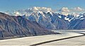
 Mount Maxwell centered on horizon
 -
 West aspect
 -
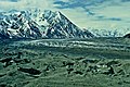 Mount Maxwell with Kaskawulsh Glacier


External links
- Parks Canada website: Kluane
- Mount Maxwell weather: MountainForecast
- Flickr photo


