Maragle, New South Wales
Town in New South Wales, Australia
35°53′54″S 148°09′04″E / 35.89833°S 148.15111°E / -35.89833; 148.15111- 19 km (12 mi) ESE of Tumbarumba
- 55 km (34 mi) NE of Corryong
- 50 km (31 mi) WNW of Cabramurra
| Mean max temp | Mean min temp | Annual rainfall |
| 16.4 °C 62 °F | 7.9 °C 46 °F | 1,219.1 mm 48 in |
Maragle is a rural locality in the southeast part of the Riverina, situated approximately 22 kilometres (14 mi) west of Cabramurra as the crow flies, or 50 kilometres (31 mi) by road. The nearest towns are Tumbarumba 19 kilometres (12 mi) to the northwest, and Corryong 55 kilometres (34 mi) to the southwest. At the 2016 census, it had a population of 58.[1]
Geography
The region varies greatly in altitude, ranging from 420 metres (1,380 ft) at the valley floor near Tooma to 1,375 metres (4,511 ft) at Pilot Reef Mountain.[2] State forest (chiefly Eucalyptus delegatensis and pinus radiata) as well as semi-cleared, undulating grazing land characterise the area.
-
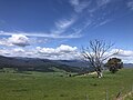 Characteristic 'emerald green' country of the Upper Murray valleys in springtime.
 -


Climate
The climate here is that of a cold rainforest, particularly in the cooler months of the year. Although high summer to mid autumn is relatively dry, springs are characterised by frequent and severe thunderstorms. Sleet and graupel are very common occurrences throughout the year (at times even in early summer) and snow often falls heavily in the winter and spring months. Low, heavy cloud dominates the winter skies. Seasonal range is especially great about the maximum temperatures, from 26 °C (79 °F) in January to just 7 °C (45 °F) in July.
Climate data are sourced from an altitude of 981 metres (3,219 ft) at Hunters Hill across the border into Victoria, operating since 1993.[3]
| Climate data for Hunters Hill (1993–2023); 981 m AMSL; 36.21° S, 147.54° E | |||||||||||||
|---|---|---|---|---|---|---|---|---|---|---|---|---|---|
| Month | Jan | Feb | Mar | Apr | May | Jun | Jul | Aug | Sep | Oct | Nov | Dec | Year |
| Record high °C (°F) | 38.8 (101.8) | 36.9 (98.4) | 32.8 (91.0) | 26.2 (79.2) | 21.3 (70.3) | 16.2 (61.2) | 13.8 (56.8) | 18.4 (65.1) | 24.5 (76.1) | 28.6 (83.5) | 33.3 (91.9) | 36.0 (96.8) | 38.8 (101.8) |
| Mean daily maximum °C (°F) | 26.1 (79.0) | 25.1 (77.2) | 21.7 (71.1) | 16.5 (61.7) | 11.7 (53.1) | 8.4 (47.1) | 7.4 (45.3) | 9.0 (48.2) | 12.3 (54.1) | 16.2 (61.2) | 19.9 (67.8) | 22.8 (73.0) | 16.4 (61.6) |
| Mean daily minimum °C (°F) | 14.6 (58.3) | 13.9 (57.0) | 11.6 (52.9) | 8.5 (47.3) | 5.4 (41.7) | 3.0 (37.4) | 2.0 (35.6) | 2.6 (36.7) | 4.6 (40.3) | 7.2 (45.0) | 10.0 (50.0) | 11.9 (53.4) | 7.9 (46.3) |
| Record low °C (°F) | 3.0 (37.4) | 2.3 (36.1) | 1.6 (34.9) | −0.3 (31.5) | −2.1 (28.2) | −2.2 (28.0) | −2.6 (27.3) | −3.1 (26.4) | −4.1 (24.6) | −1.4 (29.5) | −1.0 (30.2) | 0.8 (33.4) | −4.1 (24.6) |
| Average precipitation mm (inches) | 78.8 (3.10) | 69.6 (2.74) | 72.8 (2.87) | 73.4 (2.89) | 100.7 (3.96) | 140.0 (5.51) | 150.6 (5.93) | 138.9 (5.47) | 117.0 (4.61) | 95.3 (3.75) | 100.2 (3.94) | 78.1 (3.07) | 1,219.1 (48.00) |
| Average precipitation days (≥ 0.2 mm) | 8.3 | 7.4 | 8.0 | 8.4 | 12.0 | 15.3 | 18.5 | 16.4 | 13.6 | 11.3 | 10.8 | 8.8 | 138.8 |
| Average afternoon relative humidity (%) | 43 | 47 | 48 | 58 | 73 | 82 | 80 | 74 | 68 | 58 | 52 | 46 | 61 |
| Source: Australian Bureau of Meteorology; Hunters Hill | |||||||||||||
References
- ^ a b Australian Bureau of Statistics (27 June 2017). "Maragle". 2016 Census QuickStats. Retrieved 6 June 2020.

- ^ "Pilot Reef Mountain". bonzle.com.
- ^ "Hunters Hill climate". bom.gov.au. Retrieved 8 June 2021.
- v
- t
- e
Towns and localities in Snowy Valleys Council local government area
- Adelong
- Argalong
- Bangadang
- Batlow
- Bimberi
- Black Creek
- Blowering
- Bogong Peaks Wilderness
- Bombowlee
- Bombowlee Creek
- Brindabella
- Bringenbrong
- Brungle
- Brungle Creek
- Buddong
- Burra
- Cabramurra
- Califat
- Cooleman
- Cooleys Creek
- Courabyra
- Couragago
- Darlow
- Ellerslie
- Gadara
- Geehi
- Gilmore
- Glenroy
- Gocup
- Goobarragandra
- Grahamstown
- Green Hills
- Greg Greg
- Indi
- Jagumba
- Jagungal Wilderness
- Jingellic
- Jones Bridge
- Khancoban
- Killimicat
- Kosciuszko
- Kunama
- Lacmalac
- Laurel Hill
- Little River
- Long Plain
- Lower Bago
- Mannus
- Maragle
- Minjary
- Mount Adrah
- Mount Horeb
- Munderoo
- Mundongo
- Murray Gorge
- Nurenmerenmong
- Ournie
- Paddys River
- Pilot Wilderness
- Pinbeyan
- Red Hill
- Rosewood
- Sandy Gully
- Sharps Creek
- Talbingo
- Taradale
- Tooma
- Tumbarumba
- Tumorrama
- Tumut
- Tumut Plains
- Welaregang
- Wereboldera
- Wermatong
- Westdale
- Westwood
- Willigobung
- Windowie
- Wondalga
- Wyangle
- Yarrangobilly
- Yaven Creek
Main Article: Local government areas of New South Wales


