List of scheduled monuments in Bath and North East Somerset

Bath and North East Somerset (commonly referred to as BANES or B&NES) is a unitary authority created on 1 April 1996, following the abolition of the County of Avon, which had existed since 1974.[1] Part of the ceremonial county of Somerset, Bath and North East Somerset occupies an area of 220 square miles (570 km2), two-thirds of which is green belt.[2] It stretches from the outskirts of Bristol, south into the Mendip Hills and east to the southern Cotswold Hills and Wiltshire border.[2] The city of Bath is the principal settlement in the district, but BANES also covers Keynsham, Midsomer Norton, Radstock and the Chew Valley. The area has a population of 170,000, about half of whom live in Bath, making it 12 times more densely populated than the rest of the area.[2]
A scheduled monument is a nationally important archaeological site or monument which is given legal protection by being placed on a list (or "schedule") by the Secretary of State for Culture, Media and Sport; Historic England takes the leading role in identifying such sites. The legislation governing this is the Ancient Monuments and Archaeological Areas Act 1979. The term "monument" can apply to the whole range of archaeological sites, and they are not always visible above ground. Such sites have to have been deliberately constructed by human activity. They range from prehistoric standing stones and burial sites, through Roman remains and medieval structures such as castles and monasteries, to later structures such as industrial sites and buildings constructed for the World Wars or the Cold War.[3]
There are 58 scheduled monuments in Bath and North East Somerset.[4] Some of the oldest are Neolithic, including the Stanton Drew stone circles and several tumuli. The Great Circle at Stanton Drew is one of the largest Neolithic monuments ever built, and the second largest stone circle in Britain (after Avebury). The date of construction is not known but is thought to be between 3000 and 2000 BCE, which places it in the Late Neolithic to Early Bronze Age.[5] There are also several Iron Age hillforts such as Maes Knoll,[6] which was later incorporated into the medieval Wansdyke defensive earthwork, several sections of which are included in this list.[7] The Romano-British period is represented with several sites, most notably the Roman Baths[8] and city walls in Bath.[9] More recent sites include several bridges which date from the Middle Ages to the 18th-century Palladian bridge in Prior Park Landscape Garden.[10][4] Dundas Aqueduct, built in 1805[11] to carry the Kennet and Avon Canal, is the most recent site in the list. The monuments are listed below using the names given in the English Heritage data sheets.
Map all coordinates using OpenStreetMap
Download coordinates as:
- KML
- GPX (all coordinates)
- GPX (primary coordinates)
- GPX (secondary coordinates)
Monuments
| Name | Location | Type | Completed [note 1] | Grid ref.[note 2] Geo-coordinates | Notes | Entry number [note 3] | Image | Ref. |
|---|---|---|---|---|---|---|---|---|
| Bath city walls | Bath | Defensive wall | Romano-British | ST 74941 64886 51°22′48″N 2°21′30″W / 51.3801°N 2.3583°W / 51.3801; -2.3583 (Bath city walls) Bath's first walls were built by the Romans and then extended by the Anglo-Saxons to create a fortified burh. | 1007017 | 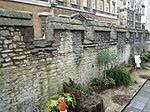 | [12][13][14] | |
| Bathampton Camp | Bathampton | Univallate hill fort | Iron Age | ST7741965033 51°23′05″N 2°19′34″W / 51.3847°N 2.3262°W / 51.3847; -2.3262 (Bathampton Camp) Bathampton Camp may have been a univallate Iron Age hill fort or stock enclosure. A rectangular enclosure, which is approximately 650 metres (2,133 ft) (east-west) by 500 metres (1,640 ft) (north-south), has been identified which may be a Medieval earthwork. | 1002480 | 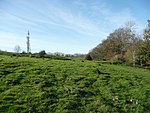 | [15] | |
| Bathford Bridge | Bathford | Bridge | 1665 | ST 78651 67004 51°24′06″N 2°18′30″W / 51.4017°N 2.3083°W / 51.4017; -2.3083 (Bathford Bridge) A stone arched bridge, which was built in 1665, carrying the A363, over the Bybrook River close to its confluence with the River Avon. | 1004515 |  | [16] | |
| Bowl barrow, Hinton Charterhouse | Hinton Charterhouse | Bowl barrow | Late Neolithic to Bronze Age | ST 77098 59208 51°19′53″N 2°19′48″W / 51.3315°N 2.3301°W / 51.3315; -2.3301 (Bowl barrow, Hinton Charterhouse) The barrow is 74 yards (68 m) in circumference and 1.2 metres (3 ft 11 in) high. Roman coins have been found at the site. | 1002474 |  Upload Photo | [17][18] | |
| Bowl barrow 90 m south-west of Bicknell Farm | Nempnett Thrubwell | Bowl barrow | Iron Age | ST 51641 62732 51°21′41″N 2°41′46″W / 51.3615°N 2.6960°W / 51.3615; -2.6960 (Bowl barrow 90 m south-west of Bicknell Farm) The bowl barrow is 26 metres (85 ft) in diameter and 2 metres (6 ft 7 in) high. In the middle Ages a windmill was built on the mound. | 1008294 | Upload Photo | [19] | |
| Bowl barrow 400 m west of Bellevue House | Nempnett Thrubwell | Bowl barrow | Late Neolithic to Bronze Age | ST 51234 60246 51°20′21″N 2°42′05″W / 51.3392°N 2.7015°W / 51.3392; -2.7015 (Bowl barrow 400 m west of Bellevue House) This barrow is 12 metres (39 ft) in diameter and 1.2 metres (3 ft 11 in) high. It was surrounded by a ditch but this has been filled in. | 1008183 | Upload Photo | [20] | |
| Bridge at Stanton Drew | Stanton Drew | Bridge | 13th or 14th century | ST 59679 63444 51°22′07″N 2°34′51″W / 51.3686°N 2.5807°W / 51.3686; -2.5807 (Bridge at Stanton Drew) A stone bridge, with two pointed arches, over the River Chew. | 1004519 |  | [21][22] | |
| Camerton Romano-British town and associated Prehistoric and early medieval monuments | Camerton | Vicus | Romano-British | ST 68646 56623 51°18′20″N 2°27′01″W / 51.3056°N 2.4503°W / 51.3056; -2.4503 (Camerton Romano-British town and associated Prehistoric and early medieval monuments) The site of a small Romano-British settlement. There is also evidence of prehistoric and medieval use. | 1013881 | Upload Photo | [23][24] [25][26] [27] | |
| Chewton Keynsham packhorse bridge | Chewton Keynsham | Packhorse bridge | Middle Ages | ST 65465 66437 51°23′45″N 2°29′52″W / 51.3959°N 2.4978°W / 51.3959; -2.4978 (Chewton Keynsham packhorse bridge) A stone two arch bridge over the River Chew. | 1004518 |  | [28] | |
| Churchyard cross in St Andrew's churchyard | Chew Magna | Cross | 15th century | ST 57674 63198 51°22′00″N 2°36′35″W / 51.3667°N 2.6097°W / 51.3667; -2.6097 (Churchyard cross in St Andrew's churchyard) A limestone cross, from which the head is missing, on an octagonal base with six steps. | 1017570 |  More images | [29] | |
| Compton Dando Bridge | Compton Dando | Bridge | Late Middle Ages | ST 64701 64686 51°22′48″N 2°30′31″W / 51.3801°N 2.5086°W / 51.3801; -2.5086 (Compton Dando Bridge) A stone bridge with three arches, over the River Chew. | 1004517 | 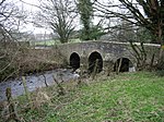 | [30] | |
| Culverhay Castle | Englishcombe | Ringwork | 11th to 13th century | ST 71906 63018 51°22′00″N 2°24′15″W / 51.3667°N 2.4043°W / 51.3667; -2.4043 (Culverhay Castle) A ringwork ditch and bank, up to 5 feet (1.5 m) deep. During the first half of the 13th century a stone circular keep and low curtain wall was built at the castle. | 1006992 |  More images | [31][32] | |
| Deserted medieval farmstead NE of Northwick | Norton Malreward | Earthwork | Middle Ages | ST 59148 66175 51°23′38″N 2°35′23″W / 51.3940°N 2.5897°W / 51.3940; -2.5897 (Deserted medieval farmstead NE of Northwick) Traces of several buildings form the 13th and 14th century have been identified. The site was reoccupied in the 18th century. | 1004524 | Upload Photo | [33] | |
| Dundas Aqueduct | Monkton Combe | Aqueduct | 1805 | ST 78460 62533 51°21′42″N 2°18′38″W / 51.3616°N 2.3105°W / 51.3616; -2.3105 (Dundas Aqueduct) Built between 1797 and 1801, the Dundas Aqueduct carries the Kennet and Avon Canal over the River Avon and the Wessex Main Line railway. It is 150 yards (137.2 m) long with three arches built of Bath Stone, with Doric pilasters, and balustrades at each end. | 1005631 |  More images | [11][34][35] | |
| Eastgate, Bath | Bath | City walls | Middle Ages | ST 75173 64872 51°22′56″N 2°21′29″W / 51.3823°N 2.3581°W / 51.3823; -2.3581 (Eastgate, Bath) The only one of the medieval gates into the city which has survived. | 1007018 | 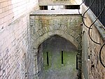 | [36]
| |
| Fairy Toot | Nempnett Thrubwell | Long barrow | Neolithic | ST 52056 61808 51°21′13″N 2°41′29″W / 51.3536°N 2.6913°W / 51.3536; -2.6913 (Fairy Toot) The Fairy Toot is an extensive oval barrow of the Severn-Cotswold tomb type which consist of precisely-built, long trapezoid earth mounds covering a burial chamber. | 1008181 | Upload Photo | [37] | |
| Hautville's Quoit | Stanton Drew | Recumbent stone | Neolithic | ST 60169 63795 51°22′17″N 2°34′31″W / 51.3715°N 2.5752°W / 51.3715; -2.5752 (Hautville's Quoit) A (now recumbent) standing stone close to the Stanton Drew stone circles. It was described by William Stukeley in 1723 as being 13 feet (4.0 m) long, it is now about half that length. | 1002475 | Upload Photo | [38][39] [40][41] [42] | |
| Hinton Priory | Hinton Charterhouse | Priory | 1232 | ST 77806 59157 51°19′50″N 2°19′17″W / 51.3306°N 2.3215°W / 51.3306; -2.3215 (Hinton Priory) A Carthusian priory established in the 13th century and suppressed as part of the dissolution of the monasteries in 1539. The chapter house, prior's cell and refectory survive as agricultural buildings belonging to the sixteenth century mansion, Hinton Abbey. Surviving earthworks from the great cloister are still visible in an orchard and paddocks. | 1007014 |  | [43] | |
| Iford Bridge | Freshford & Hinton Charterhouse | Bridge | c. 1400 | ST 80023 58896 51°19′44″N 2°17′17″W / 51.3288°N 2.2881°W / 51.3288; -2.2881 (Iford Bridge) A stone bridge with two arches carrying a minor road over the River Frome. | 1007007 | 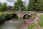 | [44] | |
| Keynsham Abbey | Keynsham | Abbey | 1170 | ST 65599 68821 51°25′02″N 2°29′46″W / 51.4172°N 2.4961°W / 51.4172; -2.4961 (Keynsham Abbey) The abbey was founded around 1170 and survived until 1539. After the dissolution the site was occupied by a house which was itself demolished in 1776. | 1005416 | 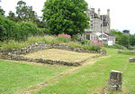 More images | [45][46][47] | |
| Lansdown camp | Charlcombe | Earthwork | Possibly Iron Age | ST 72123 69866 51°25′37″N 2°24′10″W / 51.4270°N 2.4027°W / 51.4270; -2.4027 (Lansdown camp) The remains of a bank and ditch from the Iron Age which was probably a stock enclosure. | 1002482 | Upload Photo | [48][49] | |
| Large irregular stone circle at Stanton Drew south east of Church Farm | Stanton Drew | Stone circle | Neolithic | ST 59919 63070 51°21′55″N 2°34′37″W / 51.3653°N 2.5770°W / 51.3653; -2.5770 (Large irregular stone circle at Stanton Drew south east of Church Farm) The largest stone circle is the Great Circle, 113 metres (371 ft) in diameter and the second largest stone circle in Britain (after Avebury). | 1007915 | More images | [50][51][52] | |
| Large univallate hillfort with outworks 800 m west of White Cross | West Harptree | Univallate hill fort | Iron Age | ST 58247 58497 51°19′33″N 2°35′34″W / 51.3259°N 2.5927°W / 51.3259; -2.5927 (Large univallate hillfort with outworks 800 m west of White Cross) A univallate Iron Age hillfort which has been investigated three times. In 1955 by the University of Bristol Spelaeological Society archaeologists found evidence of postholes, ditches, and pits inside the fort. | 1004526 |  | [53][54][55] | |
| Large univallate hillfort with a bowl barrow and pillow mounds 970 m west of The Bungalow | North Stoke | Univallate hill fort | Iron Age | ST 70885 68879 51°25′06″N 2°25′12″W / 51.4182°N 2.4201°W / 51.4182; -2.4201 (Large univallate hillfort with a bowl barrow and pillow mounds 970 m west of The Bungalow) A hill fort, containing bowl barrows and pillow mounds, surrounded by a bank and ditch, which are now buried. | 1004677 |  | [56] | |
| Lock Up, Monkton Combe | Monkton Combe | Village lock-up | 18th century | ST 77358 61957 51°21′22″N 2°19′34″W / 51.3562°N 2.3261°W / 51.3562; -2.3261 (Lock Up, Monkton Combe) A small stone building with a domed roof. Probably built around 1776. | 1004541 |  | [57] | |
| Maes Knoll | Norton Malreward | Hill fort | Iron Age | ST 60001 65961 51°23′32″N 2°34′32″W / 51.3921°N 2.5756°W / 51.3921; -2.5756 (Maes Knoll) The hillfort, which is approximately 390 by 84 feet (119 m × 26 m), and 45 feet (14 m) in height, covering 20 acres (8.1 ha), consists of a fairly large flat open area, roughly triangular in shape, that has been fortified by ramparts and shaping of the steep-sided hilltop around the northern, eastern and southwestern sides of the hill. It rises to an altitude of 197 metres (646 ft) above sea level. | 1005424 | 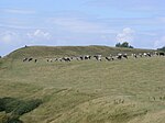 More images | [58] | |
| Newton St Loe Castle | Newton St Loe | Fortified manor house | 12th century | ST 69408 64003 51°22′27″N 2°26′27″W / 51.3743°N 2.4409°W / 51.3743; -2.4409 (Newton St Loe Castle) Originally built as a fortified manor house, probably in the 12th century, surrounded by Newton Park, then a medieval deer park. At the start of the 14th century, a keep was built on the site, creating a rectangular, courtyard castle with four corner towers, protected by a ditch on three sides. | 1006993 | 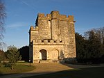 More images | [59][60] | |
| Oval enclosure, possibly Iron Age, SW of Stowey House | Stowey | Ringwork | Iron Age | ST 59738 59287 51°19′52″N 2°34′45″W / 51.3312°N 2.5793°W / 51.3312; -2.5793 (Oval enclosure, possibly Iron Age, SW of Stowey House) The ringwork has a 3 metres (9.8 ft) wide bank and 7 metres (23 ft) wide ditch. There is limited evidence that it was the site of a castle. | 1004606 | 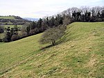 | [61][62] | |
| Palladian Bridge, Prior Park, Bath | Prior Park Landscape Garden | Bridge | 1750s | ST 76076 63326 51°22′07″N 2°20′42″W / 51.3685°N 2.3450°W / 51.3685; -2.3450 (Palladian Bridge, Prior Park, Bath) The bridge crosses a dam between two lakes. It is copied from a similar bridge at Wilton House and has a pulvinated frieze. | 1004514 | 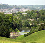 | [63][10] | |
| Part of the linear boundary known as the Wansdyke 425 m south of New Barn Farm | Norton Malreward | Earthwork | Prehistoric but modified in the Early Middle Ages | ST6103865517 51°23′14″N 2°33′41″W / 51.3873°N 2.5613°W / 51.3873; -2.5613 (Part of the linear boundary known as the Wansdyke 425 m south of New Barn Farm) A bank and ditch. Part of the surviving remains of the Wansdyke. | 1003066 | 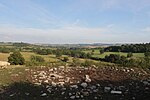 | [64] | |
| Part of the linear boundary known as the Wansdyke: section E of Maes Knoll camp | Norton Malreward | Earthwork | Prehistoric but modified in the Early Middle Ages | ST 60361 65898 51°23′27″N 2°34′16″W / 51.3907°N 2.5711°W / 51.3907; -2.5711 (Part of the linear boundary known as the Wansdyke: section E of Maes Knoll camp) A bank and ditch. Part of the surviving remains of the Wansdyke. | 1007009 |  | [65] | |
| Part of the linear boundary known as the Wansdyke 585 m north of Tuckingmill Farm | Compton Dando | Earthwork | Prehistoric but modified in the Early Middle Ages | ST 65393 64400, 51°22′47″N 2°30′14″W / 51.3798°N 2.5038°W / 51.3798; -2.5038 (Part of the linear boundary known as the Wansdyke 585 m north of Tuckingmill Farm) A bank and ditch. Part of the surviving remains of the Wansdyke. | 1007004 |  | [66] | |
| Part of the linear boundary known as the Wansdyke 210 m north west of Cottles | Publow | Earthwork | Prehistoric but modified in the Early Middle Ages | ST 62219 65263 51°23′07″N 2°32′51″W / 51.3854°N 2.5475°W / 51.3854; -2.5475 (Part of the linear boundary known as the Wansdyke 210 m north west of Cottles) A bank and ditch. Part of the surviving remains of the Wansdyke. | 1007010 |  | [4] | |
| Part of the linear boundary known as the Wansdyke 375 m south east of Knowle Farm | Compton Dando | Earthwork | Prehistoric but modified in the Early Middle Ages | ST6446664935 51°22′56″N 2°30′43″W / 51.3823°N 2.5120°W / 51.3823; -2.5120 (Part of the linear boundary known as the Wansdyke 375 m south east of Knowle Farm) A bank and ditch. Part of the surviving remains of the Wansdyke. | 1004523 | 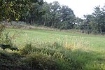 | [4] | |
| Part of the linear boundary known as the Wansdyke 420 m south west of Barrowmead Cottage | Englishcombe | Earthwork | Prehistoric but modified in the Early Middle Ages | ST7268162210 51°21′30″N 2°23′37″W / 51.3583°N 2.3937°W / 51.3583; -2.3937 (Part of the linear boundary known as the Wansdyke 420 m south west of Barrowmead Cottage) A bank and ditch. Part of the surviving remains of the Wansdyke. | 1007005 |  | [4] | |
| Part of the linear boundary known as the Wansdyke 285 m north west of Manor Farm | Englishcombe | Earthwork | Prehistoric but modified in the Early Middle Ages | ST 71306 62936 51°21′56″N 2°25′06″W / 51.3655°N 2.4184°W / 51.3655; -2.4184 (Part of the linear boundary known as the Wansdyke 285 m north west of Manor Farm) A bank and ditch. Part of the surviving remains of the Wansdyke. | 1007006 | 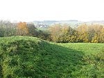 | [4] | |
| Part of the linear boundary known as the Wansdyke 530 m north west of Park Farm | Newton St Loe | Earthwork | Prehistoric but modified in the Early Middle Ages | ST6890363597 51°22′10″N 2°26′29″W / 51.3695°N 2.4413°W / 51.3695; -2.4413 (Part of the linear boundary known as the Wansdyke 530 m north west of Park Farm) A bank and ditch. Part of the surviving remains of the Wansdyke. | 1007008 | Upload Photo | [67] | |
| Part of the linear boundary known as the Wansdyke: section 1230 yd (1120 m) eastwards from Burnt House Inn | Bath | Earthwork | Prehistoric but modified in the Early Middle Ages | ST 74053 61803 51°21′17″N 2°22′26″W / 51.3547°N 2.3740°W / 51.3547; -2.3740 (Part of the linear boundary known as the Wansdyke: section 1230 yd (1120 m) eastwards from Burnt House Inn) A bank and ditch. Part of the surviving remains of the Wansdyke. | 1007003 |  | [4] | |
| Part of a Roman road 565 m north of Abbey Farm | Hinton Charterhouse | Earthwork | Romano-British | ST 77083 59521 51°20′03″N 2°19′49″W / 51.3343°N 2.3303°W / 51.3343; -2.3303 (Part of a Roman road 565 m north of Abbey Farm) The remains of a Roman road part of which is visible as an Earthwork; however some sections are only visible as crop marks on aerial photographs. | 1005421 | Upload Photo | [68][69]
| |
| Queen Charlton village cross | Queen Charlton | Cross | 15th century | ST 63418 67057 51°24′06″N 2°31′38″W / 51.4018°N 2.5271°W / 51.4018; -2.5271 (Queen Charlton village cross) A stone cross on a base with five steps. | 1015510 | 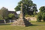 | [70] | |
| Richmont Castle | East Harptree | Earthwork | 11th century | ST 56137 55835 51°18′00″N 2°37′44″W / 51.3001°N 2.6289°W / 51.3001; -2.6289 (Richmont Castle) The 11th century castle had a single bailey on the south side, possibly making use of an existing Iron Age fortification. Later an inner bailey was added and a circular keep surrounded by a park. The castle was ruined and abandoned by the 1540s and little apart from earthworks are visible today. | 1006991 | 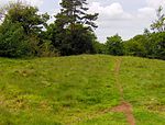 | [71] | |
| Roman Baths and site of Roman town, Bath | Bath | Baths | Romano-British | ST 74846 64803 51°22′51″N 2°21′34″W / 51.3809°N 2.3595°W / 51.3809; -2.3595 (Roman Baths and site of Roman town, Bath) A Roman site for public bathing which used natural warm springs and surrounding buildings. All of the Roman features are now beneath street level. The buildings above street level date from the 19th century. | 1004678 |  More images | [72][73][74] | |
| Roman camp 405 m west of The Bungalow | North Stoke | Earthwork | Romano-British | ST7142968918 51°25′07″N 2°24′44″W / 51.4186°N 2.4123°W / 51.4186; -2.4123 (Roman camp 405 m west of The Bungalow) A rectangular enclosure approximately 100 metres (330 ft) long and 55 metres (180 ft) wide internally, surrounded by a 1 metre (3 ft 3 in) high stony bank. | 1005422 | 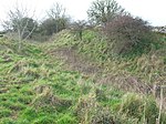 | [75][76] | |
| Roman Settlement at Keynsham Hams, former Cadbury's Factory | Keynsham | Roman villa | Romano-British | ST6535769411 51°25′23″N 2°29′41″W / 51.4231°N 2.4946°W / 51.4231; -2.4946 (Roman Settlement at Keynsham Hams, former Cadbury's Factory) The remains of a Roman settlement, most of which is now beneath ground level. It is within the grounds of an early-20th-century industrial site. | 1416459 |  | [77][78] | |
| Roman villa at Upper Hayes | Wellow | Earthwork | Romano-British | ST7142968918 51°19′13″N 2°23′29″W / 51.3204°N 2.3915°W / 51.3204; -2.3915 (Roman villa at Upper Hayes) The site of a Roman villa which had two corridors, mosaics, hypocausts and baths is bow marked by posts in the ground. A relief from the site is now in the British Museum. The site is on the English Heritage list of Heritage at Risk. | 1007002 | Upload Photo | [79][80] [27][81] | |
| Romano-British settlement E of Sir Bevil Granville's Monument | Charlcombe | Earthwork | Romano-British | ST7245870244 51°25′50″N 2°23′51″W / 51.4305°N 2.3976°W / 51.4305; -2.3976 (Romano-British settlement E of Sir Bevil Granville's Monument) The site of a Roman settlement or temple and associated buildings possibly used for iron and pewter manufacture. Several stone coffins were found at or near the site. The earthworks of the site are visible in aerial photographs. | 1004527 | 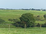 | [82] | |
| Round House, Pensford | Pensford | Village lock-up | 18th century | ST 61993 63762 51°22′18″N 2°32′50″W / 51.3716°N 2.5472°W / 51.3716; -2.5472 (Round House, Pensford) An octagonal eighteenth-century village lock-up. | 1005423 | 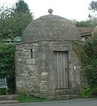 More images | [83] | |
| Saltford Brass Mill | Saltford | Brass mill | 1720s | ST 68724 67011 51°24′04″N 2°27′04″W / 51.4011°N 2.4511°W / 51.4011; -2.4511 (Saltford Brass Mill) The site includes a battery mill and a complete annealing furnace. There are also the remains of the water wheels initially used to power the machinery, one of which is still in working order. The battery mills were supplemented by rolling mills between 1760 and 1830. The mill ceased production in 1924. | 1004607 |  | [84] | |
| Sir Bevil Grenville's Monument | Lansdown Hill | Monument | 1720 | ST 72190 70345 51°25′53″N 2°23′58″W / 51.4314°N 2.3994°W / 51.4314; -2.3994 (Sir Bevil Grenville's Monument) Erected in 1720 to commemorate the heroism of the Civil War Royalist commander Sir Bevil Grenville who on 5 July 1643 fell mortally wounded at the Battle of Lansdowne. The monument is of ashlar stone masonry, 25 feet (7.6 m) high, in the English Baroque style. | 1015110 | 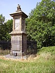 More images | [85] | |
| Slight univallate hillfort 190 m north west of Westleigh | Batheaston | Univallate hill fort | Iron Age | ST 76856 67925 51°24′36″N 2°20′03″W / 51.41°N 2.3342°W / 51.41; -2.3342 (Slight univallate hillfort 190 m north west of Westleigh) Solsbury Hill is a small flat-topped hill and the site of an Iron Age hill fort occupied between 300 BC and 100 BC. The rampart was 20 feet (6 m) wide and the outer face was at least 12 feet (4 m) high. It is a possible location of the Battle of Badon. It was acquired by the National Trust in 1930. People protesting against the building of an A46 bypass road cut a small turf maze into the hill. It is also the inspiration for rock musician Peter Gabriel's first solo single in 1977. | 1002481 | 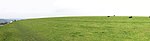 More images | [86][87] [88][89][90] | |
| Slight univallate hillfort 125 m west of Tunley Farm | Camerton | Univallate hill fort | Late Bronze Age to Iron Age | ST 68346 59176 51°19′51″N 2°27′21″W / 51.3308°N 2.4557°W / 51.3308; -2.4557 (Slight univallate hillfort 125 m west of Tunley Farm) The site of a Univallate hill fort. Some earthworks remain as a bank and ditch. | 1004525 | Upload Photo | [91] | |
| Stantonbury camp and adjacent sections of Wansdyke | Stanton Prior | Hill fort | Iron Age | ST 67450 63711 51°22′15″N 2°28′20″W / 51.3708°N 2.4722°W / 51.3708; -2.4722 (Stantonbury camp and adjacent sections of Wansdyke) The hillfort, which is at the top of an isolated outcrop of Oolitic Limestone, is on the route of the Wansdyke. Several iron agricultural implements, recovered from the site, including blades of sickles or pruning hooks and the iron tip from an ard, are now in the collection of the British Museum. The site is on the English Heritage Heritage at Risk Register as being in danger of deterioration because of extensive animal burrowing. | 1002487 |  | [62][92][93] | |
| Stone cove at Stanton Drew 25 m south west of St Mary's Church | Stanton Drew | Standing stone | Neolithic | ST 59750 63100 51°21′56″N 2°34′47″W / 51.3656°N 2.5796°W / 51.3656; -2.5796 (Stone cove at Stanton Drew 25 m south west of St Mary's Church) a cove of two standing stones with a recumbent slab between them, which can be found in the garden of the Druid's Arms public house. All are of different heights, the stone to the north east being 4.4 metres (14 ft) the south western 3.1 metres (10 ft), and the north eastern 1.4 metres (4 ft 7 in). The stones of The Cove are mineralogically different from those in the nearby Stanton Drew stone circles. A long barrow burial chamber has been found under the stones of The Cove. It is thought that this predates the erection of the stones by approximately a thousand years. | 1007916 | 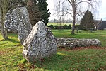 More images | [94][95] | |
| Stoney Littleton Long Barrow | Wellow | Long barrow | Neolithic | ST 73492 57208 51°18′48″N 2°22′53″W / 51.3133°N 2.3813°W / 51.3133; -2.3813 (Stoney Littleton Long Barrow) A Neolithic chambered tomb with multiple burial chambers, of the Severn-Cotswold tomb type. The barrow is about 30 metres (98 ft) in length and 15 metres (49 ft) wide at the south-east end, it stands nearly 3 metres (10 ft) high. Internally it consists of a 12.8 metres (42 ft) long gallery with three pairs of side chambers and an end chamber. There is a fossil ammonite decorating the left-hand doorjamb. | 1007910 |  More images | [96][97] | |
| Two stone circles and two stone avenues at Stanton Drew, east of Court Farm | Stanton Drew | Henge | Neolithic | ST 60034 63272 51°22′04″N 2°34′31″W / 51.3678°N 2.5753°W / 51.3678; -2.5753 (Two stone circles and two stone avenues at Stanton Drew, east of Court Farm) The largest stone circle is the Great Circle, 113 metres (371 ft) in diameter. The date of construction is not known but is thought to be between 3000 and 2000 BCE. The Great Circle was surrounded by a ditch and is accompanied by smaller stone circles to the north east and south west. Some of the stones are still vertical, but the majority are now recumbent and some are no longer present. | 1007911 |  More images | [98][99] [100][101] | |
| Tun Bridge | Chew Magna | Bridge | 15th century | ST 57693 62905 51°21′49″N 2°36′33″W / 51.3637°N 2.6091°W / 51.3637; -2.6091 (Tun Bridge) A 15th century stone bridge with three pointed arches. It carries a minor round over the River Chew. | 1004516 | 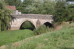 | [102][103]
| |
| Two round barrows north of Blathwayt Arms | Charlcombe | Round barrows | Bronze Age | ST 72520 68706 51°24′59″N 2°23′46″W / 51.4165°N 2.3962°W / 51.4165; -2.3962 (Two round barrows north of Blathwayt Arms) Some earthwork remains of bowl barrows, highest of which is 2 metres (6 ft 7 in) high. | 1002471 | Upload Photo | [4][104] | |
| Ubley Manor House | Ubley | Earthwork | 14th century | ST 52904 58338 51°19′15″N 2°40′31″W / 51.3209°N 2.6752°W / 51.3209; -2.6752 (Ubley Manor House) Some walling remains from a 14th century manor house which was largely demolished in the 20th century. | 1004543 | Upload Photo | [105][106] |
See also
- Scheduled monuments in Somerset
- Grade I listed buildings in Bath and North East Somerset
- Grade II* listed buildings in Bath and North East Somerset
Notes
- ^ The date given is the date used by Historic England as significant for the initial building or that of an important part in the structure's description.
- ^ Sometimes known as OSGB36, the grid reference is based on the British national grid reference system used by the Ordnance Survey.
- ^ The "List Entry Number" is a unique number assigned to each listed building and scheduled monument by Historic England.
References
- ^ "The Avon (Structural Change) Order 1995". Her Majesty's Stationery Office (HMSO). Archived from the original on 30 January 2008. Retrieved 9 December 2007.
- ^ a b c "About the area". Bath and North East Somerset Council. Archived from the original on 4 November 2007. Retrieved 30 December 2007.
- ^ "Scheduled Monuments". English Heritage. Retrieved 9 September 2014.
- ^ a b c d e f g h "List of Scheduled Monuments". Bath and North East Somerset. Retrieved 9 September 2014.
- ^ Oswin, John; Richards, John; Sermon, Richard. "Stanton Drew 2010 Geophysical survey and other archaeological investigations" (PDF). Bath and North East Somerset Council. p. 63. Retrieved 21 August 2014.
- ^ Historic England. "Maes Knoll (201029)". Research records (formerly PastScape). Retrieved 24 March 2011.
- ^ "Wansdyke Project 21". Wansdyke Project 21. Retrieved 7 September 2014.
- ^ "The Roman Baths". Bath and North East Somerset Council. Retrieved 7 September 2014.
- ^ Creighton, Oliver Hamilton and Robert Higham. (2005) Medieval Town Walls: an Archaeology and Social History of Urban Defence. Stroud, UK: Tempus. ISBN 978-0-7524-1445-4.
- ^ a b Historic England. "Palladian Bridge in grounds of Prior Park (443307)". Images of England. Archived from the original on 18 October 2012.
- ^ a b Historic England. "Dundas Aqueduct (1215193)". National Heritage List for England. Retrieved 10 September 2006.
- ^ Creighton, Oliver; Higham, Robert (2005). Medieval Town Walls: An Archaeology and Social History of Defence. The History Press. p. 60. ISBN 978-0752414454.
- ^ Creighton, Oliver; Higham, Robert (2005). Medieval Town Walls: An Archaeology and Social History of Defence. The History Press. p. 36. ISBN 978-0752414454.
- ^ Davenport, Peter (1998). Medieval Bath Uncovered. The History Press. pp. 91–92. ISBN 978-0752419657.
- ^ Historic England. "Slight univallate hillfort called Bathampton Camp (1002480)". National Heritage List for England. Retrieved 22 July 2014.
- ^ Historic England. "Multi-span bridge called Bathford Bridge (1004515)". National Heritage List for England. Retrieved 26 July 2014.
- ^ Historic England. "Bowl barrow 150 m NNW of Abbey Farm (1002474)". National Heritage List for England. Retrieved 25 July 2014.
- ^ Historic England. "Beacon Barrow (202989)". Research records (formerly PastScape). Retrieved 25 July 2014.
- ^ Historic England. "Bowl barrow 90 m south-west of Bicknell Farm (1008294)". National Heritage List for England. Retrieved 27 July 2014.
- ^ Historic England. "Bowl barrow 400 m west of Bellevue House (1008183)". National Heritage List for England. Retrieved 27 July 2014.
- ^ Historic England. "Bridge over River Chew (1129649)". National Heritage List for England. Retrieved 9 May 2006.
- ^ "Stanton Drew". Bitton Families. Retrieved 11 December 2013.
- ^ Historic England. "Camerton Romano-British town and associated Prehistoric and early medieval monuments (1013881)". National Heritage List for England. Retrieved 27 July 2014.
- ^ Scott, Shane (1995). The hidden places of Somerset. Aldermaston: Travel Publishing Ltd. p. 22. ISBN 1-902007-01-8.
- ^ Havinden, Michael (1981). The Somerset Landscape. The making of the English landscape. London: Hodder and Stoughton Ltd. p. 69. ISBN 0-340-20116-9.
- ^ Historic England. "Camerton Roman Town (200496)". Research records (formerly PastScape). Retrieved 28 July 2014.
- ^ a b William Page, ed. (1906). "Romano-British Somerset: Part 3, Other Locations". A History of the County of Somerset: Volume 1. Institute of Historical Research. Retrieved 28 July 2014.
- ^ Historic England. "Chewton Pack Horse Bridge (1384604)". National Heritage List for England. Retrieved 27 July 2014.
- ^ Historic England. "Churchyard cross in the churchyard about 38 metres south west of tower of Church of St. Andrew (1135956)". National Heritage List for England. Retrieved 27 July 2014.
- ^ Historic England. "Road Bridge over the River Chew (1115377)". National Heritage List for England. Retrieved 26 July 2014.
- ^ Historic England. "Culverhay Castle (204528)". Research records (formerly PastScape). Retrieved 28 July 2014.
- ^ Dunning, Robert (1995). Somerset Castles. Tiverton: Somerset Books. p. 37. ISBN 978-0-86183-278-1.
- ^ Historic England. "Pickwick Farm (197885)". Research records (formerly PastScape). Retrieved 9 September 2014.
- ^ Cragg, Roger (1997). Wales and West Central England: Wales and West Central England, 2nd Edition. Thomas Telford. ISBN 0-7277-2576-9.
- ^ "Dundas Aqueduct". Kennet & Avon Canal. Archived from the original on 12 August 2014. Retrieved 10 September 2006.
- ^ Historic England. "East Gate (1394942)". National Heritage List for England. Retrieved 28 July 2014.
- ^ "Fairy Toot". Retrieved 12 May 2006.
- ^ Richards, John. "Hautville's Quoit and other archaeological investigations at Stanton Drew, 2012" (PDF). Bath and Camerton Archaeological Society. Archived from the original (PDF) on 23 February 2014. Retrieved 7 February 2014.
- ^ Dymond, Charles William (1877). "The megalithic antiquities at Stanton Drew". Journal of the British Archaeological Association. 33 (3): 297–307. doi:10.1080/00681288.1877.11888044.
- ^ Historic England. "Standing stone called Hautville's Quoit (1002475)". National Heritage List for England. Retrieved 11 December 2013.
- ^ Strong, Gordon (2008). Stanton Drew and its ancient stone circles. Wooden Books. p. 22. ISBN 978-1-904263-73-9.
- ^ Burl, Aubrey (1993). From Carnac to Callanish: Prehistoric Stone Rows of Britain, Ireland and Brittany. Yale University Press. p. 187. ISBN 978-0-300-05575-7.
Stanton Drew Hauteville Quoit.
- ^ Greenwood, Charles (1977). Famous houses of the West Country. Bath: Kingsmead Press. pp. 40–43. ISBN 978-0-901571-87-8.
- ^ Historic England. "Iford Bridge (1115316)". National Heritage List for England. Retrieved 28 July 2014.
- ^ "Houses of Augustinian canons: The abbey of Keynsham". Somerset Victoria County History. British History Online. 1911. pp. 129–132. Retrieved 19 July 2009.
- ^ Historic England. "Keynsham Abbey pier base in the garden of No.3 (1384576)". National Heritage List for England. Retrieved 19 July 2009.
- ^ Historic England. "Keynsham Abbey, remains to the south of No.3 (1384577)". National Heritage List for England. Retrieved 19 July 2009.
- ^ Historic England. "Lansdown Camp (203737)". Research records (formerly PastScape). Retrieved 27 July 2014.
- ^ "Lansdown Camp". The Megalithic Portal. Retrieved 27 July 2014.
- ^ Bull, Larry. "On Stanton Drew, Avebury and Stonehenge". University of the West of England. Retrieved 1 December 2013.
- ^ Pollard, Joshua (2008). "Chapter 4 Neolithic and Early Bronze Age". In Webster, C.J. (ed.). The Archaeology of South West England (PDF). Somerset County Council. pp. 75–102. ISBN 978-0-86183-392-4. Archived from the original (PDF) on 2 December 2013. Retrieved 12 December 2013.
- ^ Historic England. "Two stone circles and two stone avenues at Stanton Drew, east of Court Farm (1007911)". National Heritage List for England. Retrieved 11 December 2013.
- ^ Historic England. "Burledge Hillfort (197270)". Research records (formerly PastScape). Retrieved 22 December 2010.
- ^ "Mendip Hills An Archaeological Survey of the Area of Outstanding Natural Beauty" (PDF). Somerset County Council Archeological Projects. Retrieved 16 January 2011.
- ^ ApSimon, A. M. (1955). Archaeological Notes (PDF) (Report). University of Bristol Spelaeological Society. Retrieved 22 December 2010.
- ^ Historic England. "Large univallate hillfort with a bowl barrow and pillow mounds 970 m west of The Bungalow (1004677)". National Heritage List for England. Retrieved 27 July 2014.
- ^ Historic England. "Lock-up (1288263)". National Heritage List for England. Retrieved 18 July 2010.
- ^ "Maes Knoll". Megalithic Portal. Retrieved 25 July 2010.
- ^ Pettifer, Adrian (2002). English Castles: A Guide by Counties. Boydell Press. p. 222. ISBN 978-0851157825.
- ^ Historic England. "St Loes Castle (201108)". Research records (formerly PastScape). Retrieved 28 July 2014.
- ^ "Stowey Castle, Stowey Sutton". Gatehouse gazetteer of the medieval fortifications and castles of England and Wales. Retrieved 25 April 2006.
- ^ a b "A Landscape Character Assessment" (PDF). Rural Landscapes. Bath and North East Somerset Council. Retrieved 9 September 2014.
- ^ Historic England. "Prior Park (1000144)". National Heritage List for England. Retrieved 25 July 2014.
- ^ Historic England. "Part of the linear boundary known as the Wansdyke 425 m south of New Barn Farm (1003066)". National Heritage List for England. Retrieved 22 July 2014.
- ^ Historic England. "West Wansdyke (1066087)". Research records (formerly PastScape). Retrieved 9 September 2014.
- ^ Historic England. "Part of the linear boundary known as the Wansdyke 585 m north of Tuckingmill Farm (1007004)". National Heritage List for England. Retrieved 26 July 2014.
- ^ Historic England. "Part of the linear boundary known as the Wansdyke 530 m north west of Park Farm (1007008)". National Heritage List for England. Retrieved 27 July 2014.
- ^ Historic England. "Part of a Roman road 565 m north of Abbey Farm (1005421)". National Heritage List for England. Retrieved 27 July 2014.
- ^ Historic England. "Monument No. 1166109". Research records (formerly PastScape). Retrieved 27 July 2014.
- ^ Historic England. "Queen Charlton village cross (1015510)". National Heritage List for England. Retrieved 10 August 2014.
- ^ Brown, Graham. "Richmont Castle, East Harptree: An Analytical Earthwork Survey, English Heritage Research Department Report No. 73" (PDF). English Heritage. Archived from the original (PDF) on 12 August 2014. Retrieved 28 July 2014.
- ^ "City of Bath World Heritage Site Management Plan". Bath and North East Somerset. Archived from the original on 14 June 2007. Retrieved 1 November 2007.
- ^ "The Roman Baths". TimeTravel Britain. Retrieved 1 November 2007.
- ^ "The Roman Baths". BirminghamUk.com. Retrieved 1 November 2007.
- ^ Historic England. "Roman camp 405 m west of The Bungalow (1005422)". National Heritage List for England. Retrieved 27 July 2014.
- ^ Historic England. "Lansdown Camp (203719)". Research records (formerly PastScape). Retrieved 27 July 2014.
- ^ Historic England. "Roman Well (Grade II) (1384575)". National Heritage List for England. Retrieved 1 January 2012.
- ^ "Keynsham Heritage Trust". Keynsham Heritage Trust. Archived from the original on 26 March 2011. Retrieved 25 April 2010.
- ^ Historic England. "Monument No. 203043". Research records (formerly PastScape). Retrieved 28 July 2014.
- ^ Hungley, Richard (2008). The Recovery of Roman Britain 1586–1906 : A Colony So Fertile. Oxford University Press. p. 169. ISBN 9780191553196.
- ^ "Roman villa at Upper Hayes". Heritage at Risk Register. English Heritage. Retrieved 28 October 2015.
- ^ Historic England. "Monument No. 205009". Research records (formerly PastScape). Retrieved 9 September 2014.
- ^ Mason, Edmund J. & Mason, Doreen (1982). Avon Villages. Robert Hale Ltd. ISBN 0-7091-9585-0.
- ^ "Local History". Bristol and Bath Railway Path. Retrieved 10 September 2011.
- ^ "Sir Bevil Grenville's Monument". English Heritage. Retrieved 20 July 2009.
- ^ Dowden, W.A. "Little Solsbury Hill Camp. Report on Excavations of 1955 and 1956" (PDF). Proceedings of the University of Bristol Speleological Society. 18 (1): 18–29.
- ^ Dowden, W.A. "Little Solsbury Hill Camp. Report on Excavations of 1958" (PDF). Proceedings of the University of Bristol Speleological Society. 9 (3): 177–182.
- ^ Historic England. "Solsbury Hill (203323)". Research records (formerly PastScape). Retrieved 8 June 2014.
- ^ Tratman, E.K. "Little Solsbury Hill Camp" (PDF). Bath and Camerton Archaeological Society. Archived from the original (PDF) on 14 July 2014. Retrieved 8 June 2014.
- ^ Ciceran, Marissa. "General History of Hillforts". Istrianet. Retrieved 8 June 2014.
- ^ Historic England. "Slight univallate hillfort 125 m west of Tunley Farm (1004525)". National Heritage List for England. Retrieved 27 July 2014.
- ^ "Stantonbury Hill". Wansdyke Project 21.
- ^ Historic England. "Stantonbury camp and adjacent sections of Wansdyke (1002487)". National Heritage List for England. Retrieved 22 July 2014.
- ^ "Study of Stanton Drew stone circle reveals new secrets". BBC. Retrieved 1 December 2013.
- ^ Historic England. "Stone cove at Stanton Drew 25 m south west of St Mary's Church (1007916)". National Heritage List for England. Retrieved 11 December 2013.
- ^ Scott, Shane (1995). The hidden places of Somerset. Aldermaston: Travel Publishing Ltd. p. 16. ISBN 1-902007-01-8.
- ^ Dunn, Richard (2004). Nempnett Thrubwell:Barrows, Names and Manors. Nempnett Books. pp. 33–62. ISBN 0-9548614-0-X.
- ^ McIntosh, Jane (2009). Handbook of Life in Prehistoric Europe. Oxford University Press. p. 266. ISBN 978-0-19-538476-5.
- ^ "History and research: Stanton Drew circles and cove". Portico. English Heritage. Retrieved 12 December 2013.
- ^ David, Andrew (28 April 1998). "Stanton Drew". PAST the Newsletter of the Prehistoric Society. 71 (1851): 584. Bibcode:1905Natur..71..584L. doi:10.1038/071584a0. S2CID 4059455. Retrieved 1 December 2013.
- ^ "Stanton Drew Stone Circles". English Heritage Archeometry. Archived from the original on 20 August 2006. Retrieved 8 July 2006.
- ^ "Rising Main and Sewage Pumping Station, Chew Magna, North East Somerset. Phase 1: Trial pits and boreholes. An Archaeological Watching Brief" (PDF). ContextOne. Archived from the original (PDF) on 20 August 2007. Retrieved 19 September 2007.
- ^ Historic England. "Tun Bridge (1129627)". National Heritage List for England. Retrieved 9 May 2006.
- ^ Historic England. "Monument No. 203734". Research records (formerly PastScape). Retrieved 18 October 2014.
- ^ Historic England. "Ubley Manor House (197418)". Research records (formerly PastScape). Retrieved 28 July 2014.
- ^ "Ubley Manor House (remains of)". Heritage Gateway. English Heritage. Retrieved 28 July 2014.
- v
- t
- e
- Bedfordshire
- Berkshire
- Bristol
- Buckinghamshire
- Cambridgeshire
- Cheshire
- (before 1066)
- (1066–1539)
- (since 1539)
- Cornwall
- Cumbria
- Derbyshire
- Devon
- Dorset
- County Durham
- East Sussex
- Essex
- Gloucestershire
- Greater London
- Greater Manchester
- Hampshire
- Herefordshire
- Hertfordshire
- Kent
- Lancashire
- Leicestershire
- Lincolnshire
- Merseyside
- Norfolk
- North Yorkshire
- Northamptonshire
- Northumberland
- Nottinghamshire
- Oxfordshire
- Shropshire
- Somerset
- Bath and North East Somerset
- Mendip
- North Somerset
- Sedgemoor
- South Somerset
- Somerset West and Taunton
- Taunton Deane
- West Somerset
- A–G
- H–Z
- South Yorkshire
- Staffordshire
- Suffolk
- Surrey
- Tyne and Wear
- Warwickshire
- West Midlands
- West Sussex
- West Yorkshire
- Wiltshire
- Worcestershire


