Lake Hibara
Lake in Japan
37°41′0″N 140°3′20″E / 37.68333°N 140.05556°E / 37.68333; 140.05556Wikimedia Commons has media related to Lake Hibara.
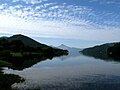
Lake Hibara (桧原湖, Hibara-ko) is a lake located in Yama District, Fukushima, Japan. It is a part of the Bandai-Asahi National Park and is the largest of the lakes in the Bandai Highland.[1]
Formation
A mesotrophic lake, Lake Hibara was formed as a result of the July 15, 1888 eruption of Mount Bandai. The resulting debris avalanche created a natural dam that then filled with water, submerging Hibara Village (桧原村, Hibara-mura). The remains of Hibara Village still lie at the bottom of the lake.[2]
Recreation
A tourist industry has built up around Lake Hibara, offering hiking trails, pleasure cruises, and campgrounds and other lodging. In the winter, ice fishing is popular.
Climate
| Climate data for Lake Hibara (1991−2020 normals, extremes 1978−present) | |||||||||||||
|---|---|---|---|---|---|---|---|---|---|---|---|---|---|
| Month | Jan | Feb | Mar | Apr | May | Jun | Jul | Aug | Sep | Oct | Nov | Dec | Year |
| Record high °C (°F) | 10.0 (50.0) | 13.9 (57.0) | 16.1 (61.0) | 24.4 (75.9) | 29.2 (84.6) | 30.1 (86.2) | 31.5 (88.7) | 32.0 (89.6) | 30.2 (86.4) | 25.5 (77.9) | 19.9 (67.8) | 16.6 (61.9) | 32.0 (89.6) |
| Mean daily maximum °C (°F) | −0.6 (30.9) | 0.2 (32.4) | 3.9 (39.0) | 10.8 (51.4) | 17.4 (63.3) | 20.7 (69.3) | 24.1 (75.4) | 25.5 (77.9) | 21.3 (70.3) | 15.2 (59.4) | 8.9 (48.0) | 2.4 (36.3) | 12.5 (54.5) |
| Daily mean °C (°F) | −4.2 (24.4) | −4.0 (24.8) | −0.7 (30.7) | 5.0 (41.0) | 11.5 (52.7) | 15.7 (60.3) | 19.7 (67.5) | 20.6 (69.1) | 16.4 (61.5) | 10.1 (50.2) | 4.2 (39.6) | −1.2 (29.8) | 7.8 (46.0) |
| Mean daily minimum °C (°F) | −8.8 (16.2) | −9.4 (15.1) | −5.7 (21.7) | −0.4 (31.3) | 5.4 (41.7) | 10.8 (51.4) | 15.7 (60.3) | 16.4 (61.5) | 12.0 (53.6) | 5.3 (41.5) | −0.3 (31.5) | −5.1 (22.8) | 3.0 (37.4) |
| Record low °C (°F) | −21.7 (−7.1) | −22.9 (−9.2) | −18.1 (−0.6) | −10.9 (12.4) | −2.9 (26.8) | 0.5 (32.9) | 4.8 (40.6) | 5.6 (42.1) | 0.5 (32.9) | −5.5 (22.1) | −11.9 (10.6) | −16.7 (1.9) | −22.9 (−9.2) |
| Average precipitation mm (inches) | 145.1 (5.71) | 110.3 (4.34) | 119.1 (4.69) | 113.1 (4.45) | 117.9 (4.64) | 151.4 (5.96) | 259.2 (10.20) | 214.7 (8.45) | 160.1 (6.30) | 136.2 (5.36) | 130.7 (5.15) | 165.2 (6.50) | 1,822.8 (71.76) |
| Average rainy days (≥ 1.0 mm) | 19.9 | 17.3 | 16.9 | 13.8 | 12.3 | 12.3 | 16.3 | 12.9 | 13.4 | 12.7 | 15.6 | 20.3 | 183.7 |
| Mean monthly sunshine hours | 42.9 | 53.3 | 92.7 | 143.1 | 166.6 | 134.1 | 112.6 | 151.5 | 115.8 | 108.1 | 82.3 | 53.1 | 1,256.1 |
| Source: Japan Meteorological Agency[3][4] | |||||||||||||
Gallery
-
 Lake Hibara with snow
 -
 Looking south
 -
 Submerged torii from the former location of Hibara Village.


Notes
References
- Takeda, Toru; Hishinuma, Tomio; Kamieda, Kinuyo; Dale, Leigh; Oguma, Chiyoichi (August 10, 1988). Hello! Fukushima - International Exchange Guide Book (1988 ed.). Fukushima City: Fukushima Mimpo Press.
- v
- t
- e
Lakes in Japan
- Chūzenji
- Inba [ja]
- Kasumigaura
- Kitaura
- Fuji Five Lakes (Kawaguchi, Motosu, Sai, Shōji, Yamanaka)
- Hamana
- Mikata Five Lakes (Mikata, Suigetsu, Suga, Kugushi, Hiruga)
- Suwa
 Lakes portal
  Japan portal
 | This Fukushima Prefecture location article is a stub. You can help Wikipedia by expanding it. |
- v
- t
- e


