Lake Gault
Small glacial lake in South Westland, New Zealand
43°25′49″S 169°59′05″E / 43.43028°S 169.98472°E / -43.43028; 169.98472
Lake Gault is a small glacial lake in South Westland, New Zealand, near the township of Fox Glacier. A walking track from Lake Matheson leads to the lake, which is surrounded by mature native forest. A small hydro-electric power plant was constructed piping water from the lake to power a gold mining dredge at Gillespies Beach. Endangered Ōkārito kiwi (rowi) have been released into the wild around Lake Gault.
Geography
Lake Gault is located at an altitude of 333 m (1,093 ft) in the Omoeroa Range. It has an area of 31.8 ha (79 acres) and an average depth of 14.5 m (48 ft). Its only access is via a 4-kilometre (2.5 mi) walking track that climbs 200 metres (660 ft) from the eastern shore of Lake Matheson.[1] The lake was created by glacial advance and retreat about 16,000 years ago, when moraines were deposited by what is now Fox Glacier in the Okarito Formation.[2]

Lake Gault drains into pakihi wetland to the north, part of Skiffington Swamp, which is itself drained to the west by the Waihapi Creek and to the east by the Hauraki Creek, both of which reach the coast of the Tasman Sea between Gillespies Point and the mouth of the Waikukupa River.[3]
Like nearby Lake Matheson, Lake Gault is dystrophic: its water is stained brown in colour with tannins leached from surrounding forest, low in nutrients, acidic, and has a sparse and specialised phytoplankton.[4][5] And as in Lake Matheson the dark water creates spectacular reflected views of the Southern Alps, especially Aoraki / Mount Cook and Mount Tasman.[6][7]
History
A pipeline takes water from Lake Gault over the ridgeline to a small hydroelectric power station on the Cook River flats. Built in the 1930s, the station powered a gold-mining dredge that worked the sands of Gillespies Beach 15 km to the west through to the 1940s.[6] In 1958 an earth dam was constructed between Lake Gault and Skiffington Swamp to the north to raise the lake level: by this time the hydroelectric plant was powering the village of Fox Glacier.[2]
Lake Gault Track
A track over the ridgeline was cut in the 1930s to enable servicing of the power station intake at Lake Gault, but it gradually fell into disrepair. After being abandoned for 20 years, it was reopened in April 2019 in a year-long collaboration between the Fox Glacier community and the Department of Conservation.[7][6] Repairing the overgrown track to "tramping" grade took more than a year, with volunteers carrying out most of the work.[8]
When the northern access road to the Fox Glacier was destroyed by a landslide in February 2019, the government announced a $3.9 million package to offset the loss to tourism by enhancing or upgrading other attractions in the area. One of those selected was the Lake Gault Track.[9] What had been a muddy and challenging 3–5 hour return hike was fully drained and gravelled to an "easy" grade by late 2020. A lookout point and bench at the lakeside allows views of the mountains, though these are best seen early in the morning of a calm, clear day.[6]


Flora and fauna
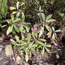
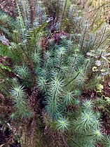
The forest around Lake Gault is largely composed of rimu, Southern rātā, and kāmahi. Horopito, tawheowheo, kiekie, and hutu are common understory trees, and ferns and mosses such as Lomaria discolor and the giant moss Dawsonia superba are found on the forest floor.
-
 Horopito (Pseudowintera colorata)
 -
 Tawheowheo (Quintinia serrata)
 -
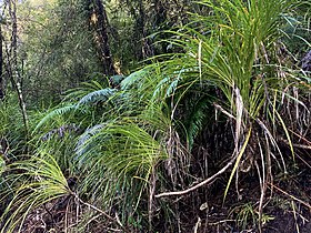 Kiekie (Freycinetia banksii)
 -
-
 Crown fern (Lomaria discolor)


As well as the usual forest birds like New Zealand tomtit, grey warbler, and fantail, the forest around Lake Gault is a reintroduction site for the rowi (Apteryx rowi), New Zealand's rarest kiwi species. By the late 1990s the world population or rowi had fallen to less than 200, all found in a single forest near Ōkārito. A species recovery programme run by the Department of Conservation called Operation Nest Egg removes rowi eggs from nesting burrows, incubates them at the West Coast Wildlife Centre, and rears the birds to adult weight on a predator-free offshore island. When Ōkārito Forest proved too crowded for further release, the forest around Lake Gault was chosen as site for a new population of rowi, and 27 were released there in December 2018.[6] Most remained within a few hundred metres of the release site, but one travelled 12 km down the coast and inland, climbing the mountains behind Fox Glacier before having to be retrieved by a search-and-rescue team at an altitude of 1250 m.[10]
References
Wikimedia Commons has media related to Lake Gault.
- ^ "Lake Gault". Lakes380. Retrieved 20 October 2020.
- ^ a b Rennison, G.; Brock, J. L. (1973). "An unusual plant community on some South Westland piedmont moraines" (PDF). Tane: The Journal of the Auckland University Field Club. 19: 223–231.
- ^ "Lake Gault," NZTopoMap. Retrieved 21 October 2020.
- ^ Jolly, Violet H. (1975). New Zealand lakes. [Auckland] N.Z.: Auckland University Press. p. 180. ISBN 0-19-647936-3. OCLC 2912748.
- ^ Flint, E. A. (1979). "Comments on the phytoplankton and chemistry of three monomictic lakes in Westland National Park, New Zealand". New Zealand Journal of Botany. 17 (2): 127–134. doi:10.1080/0028825X.1979.10426885.
- ^ a b c d e Department of Conservation (20 April 2019). "Lake Gault – a new track in the Fox area". Conservation Blog. Retrieved 20 October 2020.
- ^ a b "Lake Gault Track". Department of Conservation Te Papa Atawhai. Retrieved 20 October 2020.
- ^ "Lake Gault Track reopens in Fox Glacier". Wilderness Magazine. 20 May 2019. Retrieved 21 October 2020.
- ^ Carroll, Joanne (27 August 2019). "$3.9m Govt investment to help offset 'huge blow' of losing Fox Glacier access road". Stuff. Retrieved 20 October 2020.
- ^ "Search and rescue finds mountain climbing kiwi". Department of Conservation Te Papa Atawhai. 30 August 2019. Retrieved 22 October 2020.
- v
- t
- e
Landforms of Westland District, New Zealand
- Arthur's Pass
- Browning Pass / Nōti Raureka
- Copland Pass
- Haast Pass
and waterfalls
- Agassiz Glacier
- Douglas Glacier
- Fox Glacier
- Franz Josef Glacier
- Garden of Eden Ice Plateau
- Olivine Ice Plateau
- Volta Glacier
- Butler Range
- Southern Alps
- Mount Adams
- Aoraki / Mount Cook
- Mount Aspiring / Tititea
- Mount Brewster
- Mount Dampier
- Mount Graham
- Mount Haast
- Mount Hopkins
- La Perouse
- Lendenfeld Peak
- Mount Rolleston
- Mount Sefton
- Silberhorn
- Mount Tasman
- Mount Vancouver
- Mount Whitcombe
- Adams River
- Arahura River
- Arawhata River
- Balfour River
- Barlow River
- Barn River
- Bettne River
- Big Wainihinihi River
- Burke River
- Butler River
- Callery River
- Cascade River
- Clarke River
- Clearwater River
- Cook River / Weheka
- Copland River
- Cropp River
- Deception River
- Donald River
- Douglas River
- Drake River
- Duncan River
- Edison River
- Fork River
- Fox River
- Gorge River
- Gunn River
- Haast River
- Hacket River
- Hall River
- Hapuka River
- Harman River
- Hinatua River
- Hokitika River
- Hope River
- Jackson River
- Jerry River
- Kaniere River
- Karangarua River
- Kokatahi River
- Lambert River
- Landsborough River
- Lord River
- Macfarlane River
- Mahitahi River
- Jacobs River
- Manakaiaua River
- Maori River
- Martyr River
- Mikonui River
- Moeraki River
- Morse River
- Mueller River
- Mungo River
- Ngatau River
- North Barlow River
- Ohinemaka River
- Ōhinetamatea River
- Ōkārito River
- Okuru River
- Ōmoeroa River
- Oneone River
- Otehake River
- Ōtira River
- Ōtoko River
- Paringa River
- Perth River
- Poerua River
- Rolleston River
- Rotokino River
- Ruera River
- Ship Creek
- Smoothwater River
- Smyth River
- Spoon River
- Stafford River
- Strauchon River
- Styx River
- Taipo River
- Taramakau River
- Te Naihi River
- Te Rahotaiepa River
- Toaroha River
- Tōtara River
- Totarakaitorea River
- Troyte River
- Tuke River
- Turnbull River
- Waiatoto River
- Waiho River
- Waikūkūpa River
- Waipara River
- Waita River
- Waitaha River
- Waitangitāhuna River
- Waitangiroto River
- Wanganui River
- Whakaikai River
- Whakapohai River
- Whataroa River
- Whitcombe River
- Wilkinson River
- Willberg River
- Williamson River
- Wills River


