Lőkösháza
Village in Békés, Hungary
Place in Békés, Hungary
Lőkösháza | |
|---|---|
 The Vásárhelyi-Bréda Castle | |
| Country |  Hungary Hungary |
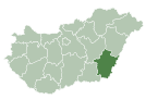
| County | Békés |
| Area | |
| • Total | 52.05 km2 (20.10 sq mi) |
| Population (2015) | |
| • Total | 1,804[1] |
| • Density | 34.7/km2 (90/sq mi) |
| Time zone | UTC+1 (CET) |
| • Summer (DST) | UTC+2 (CEST) |
| Postal code | 5743 |
| Area code | 66 |
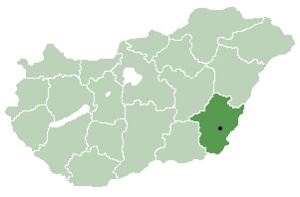
Lőkösháza (Romanian: Leucușhaz, Lăcușhaz) is a village in Békés County, in the Southern Great Plain region of southeast Hungary.
Geography
It covers an area of 52.05 km2 (20 sq mi) and has a population of 1804 (2015).[1]
An important railway line crosses the Hungarian-Romanian border here (the Budapest–Szolnok–Békéscsaba–Lőkösháza–Arad–Bucharest–Sofia–Istanbul line).
References
- ^ a b Gazetteer of Hungary, 1st January 2015. Hungarian Central Statistical Office. 03/09/2015
You can help expand this article with text translated from the corresponding article in Hungarian. (December 2009) Click [show] for important translation instructions.
- View a machine-translated version of the Hungarian article.
- Machine translation, like DeepL or Google Translate, is a useful starting point for translations, but translators must revise errors as necessary and confirm that the translation is accurate, rather than simply copy-pasting machine-translated text into the English Wikipedia.
- Do not translate text that appears unreliable or low-quality. If possible, verify the text with references provided in the foreign-language article.
- You must provide copyright attribution in the edit summary accompanying your translation by providing an interlanguage link to the source of your translation. A model attribution edit summary is
Content in this edit is translated from the existing Hungarian Wikipedia article at [[:hu:Lőkösháza]]; see its history for attribution. - You may also add the template
{{Translated|hu|Lőkösháza}}to the talk page. - For more guidance, see Wikipedia:Translation.
- v
- t
- e
- Békéscsaba (county seat)
- Almáskamarás
- Biharugra
- Bucsa
- Békéssámson
- Bélmegyer
- Csabaszabadi
- Csanádapáca
- Csárdaszállás
- Dombiratos
- Ecsegfalva
- Gerendás
- Geszt
- Hunya
- Kamut
- Kardos
- Kardoskút
- Kaszaper
- Kertészsziget
- Kisdombegyház
- Kondoros
- Kunágota
- Kétsoprony
- Körösnagyharsány
- Köröstarcsa
- Körösújfalu
- Kötegyán
- Lőkösháza
- Magyarbánhegyes
- Magyardombegyház
- Medgyesbodzás
- Mezőgyán
- Murony
- Méhkerék
- Nagybánhegyes
- Nagykamarás
- Okány
- Pusztaföldvár
- Pusztaottlaka
- Sarkadkeresztúr
- Szabadkígyós
- Tarhos
- Telekgerendás
- Végegyháza
- Zsadány
- Örménykút
- Újszalonta
- History
- Geography
- Government
- Economy
- Culture
- Tourism
46°26′N 21°14′E / 46.433°N 21.233°E / 46.433; 21.233
  | This Hungarian history article is a stub. You can help Wikipedia by expanding it. |
- v
- t
- e
 | This Romanian history-related article is a stub. You can help Wikipedia by expanding it. |
- v
- t
- e
 | This Békés County location article is a stub. You can help Wikipedia by expanding it. |
- v
- t
- e


