Kreypau
Stadtteil of Leuna in Saxony-Anhalt, Germany

Coat of arms
Location of Kreypau

51°20′N 12°3′E / 51.333°N 12.050°E / 51.333; 12.050
(2006-12-31)
06231
Kreypau is a village and a former municipality in the district of Saalekreis, in Saxony-Anhalt, Germany. Since 31 December 2009, it is part of the town Leuna.
Geography
Kreypau is located between Leuna and Leipzig on the right bank of the river Saale.
History


Kreypau was a small farming village. The village church was built in 1550/51, the tower in 1530. The village church of Wölkau was not used from 1996 until its renovation on 2018/2019.
-
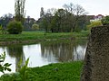
 View of the village Kreypau
 -
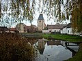 Pond and church in Kreypau
 -
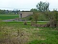
 Fire station in Kreypau
 -
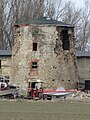 Ruin of windmill in Kreypau, 2011
 -
 River Saale at former ferry crossing near Kreypau. Leuna is in the background
 -
 Old Saale riverbed near Kreypau
 -
 Aerial photo 2021
 -
 Construction works for the Saale-Elster-Kanal in Kreypau, in the background Leuna
 -
 West side of the ruined canal lock, Wüsteneutzsch


Authority control databases | |
|---|---|
| International |
|
| National |
|
- v
- t
- e


 Kreypau