Klimkówka, Podkarpackie Voivodeship
Village in Subcarpathian Voivodeship, Poland
49°35′15″N 21°49′50″E / 49.58750°N 21.83056°E / 49.58750; 21.83056 Poland
Klimkówka [klʲimˈkufka] is a village in the administrative district of Gmina Rymanów, within Krosno County, Subcarpathian Voivodeship, in south-eastern Poland. It lies approximately 5 kilometres (3 mi) north-west of Rymanów, 13 km (8 mi) south-east of Krosno, and 52 km (32 mi) south of the regional capital Rzeszów.[1]
Gallery
-
 Church
 -
 Church
 -
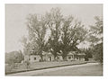
 Manor House
 -
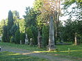
 Park
Park -
 Cemetery
 -
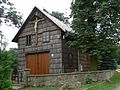
 Ostaszewski Manor
 -
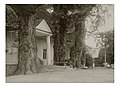 Ostaszewski Manor
 -
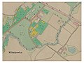 Map from 1851


References
- ^ "Central Statistical Office (GUS) - TERYT (National Register of Territorial Land Apportionment Journal)" (in Polish). 1 June 2008.
- v
- t
- e

- Bałucianka
- Bzianka
- Głębokie
- Klimkówka
- Królik Polski
- Ladzin
- Łazy
- Milcza
- Posada Górna
- Puławy
- Rudawka Rymanowska
- Rymanów-Zdrój
- Sieniawa
- Wisłoczek
- Wróblik Królewski
- Wróblik Szlachecki
- Zmysłówka
 | This Krosno County location article is a stub. You can help Wikipedia by expanding it. |
- v
- t
- e


