Kirkoswald, South Ayrshire
Human settlement in Scotland


Kirkoswald
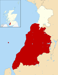
Location within South Ayrshire
- South Ayrshire
- Ayrshire and Arran
- Ayr, Carrick and Cumnock
- Carrick, Cumnock and Doon Valley
Kirkoswald (Scots: Kirkossald)[1] is a village and parish in the Carrick district of Ayrshire, Scotland, 1+3⁄4 miles (3 kilometres) from the coast and four miles (six kilometres) southwest of Maybole. It takes its name from its kirk (church), dedicated to Oswald of Northumbria, who is said to have won a battle here in the 7th century. The old church, which was built in 1244 and houses the baptismal font of Robert the Bruce, is now a ruin in the grounds of the modern church, which was built in 1777 to a design by Robert Adam. Kirkoswald is also noted for its connection with Robert Burns, whose maternal ancestors, the Brouns, were from the village. Burns also attended school here, and would later base the characters Tam o' Shanter, Kirkton Jean and souter Johnnie on village locals Douglas Graham, Jean Aird and John Davidson, the shoemaker.
Kirkoswald village had a population of 194 in 1991. Kirkoswald parish is 23.3 square miles (60 square kilometres) in area, and also contains the coastal village of Maidens. Landmarks include Turnberry Castle, the ancient seat of the Earls of Carrick, Culzean Castle, Thomaston Castle and Crossraguel Abbey.
Rev Robert Hunter Arbuckle was minister of the Free Church from 1860 and 1897.[2]
Gallery
-
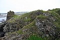
 View of the village from the neighbouring moorland
 -
 The old church
 -
 The War memorial
 -
 The grave of 'Kirkton Jean'
 -
 Grave marker for former slave Scipio Kennedy
 -
 Souter Johnnie's cottage, now owned by the National Trust
 -
 The remains of Turnberry Castle
 -
 View of Maidens village
 -
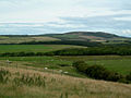 View towards Mochrum Hill


References
- The geographic coordinates are from the Ordnance Survey.
External links
- The Gazetteer for Scotland - Kirkoswald
- Kirkoswald Parish Profile
 Media related to Kirkoswald, South Ayrshire at Wikimedia Commons
- v
- t
- e
- Former burghs
- Ballantrae
- Girvan
- Maybole
- Others
- Auchencrosh
- Balkissock
- Bargany
- Barr
- Colmonell
- Crosshill
- Dailly
- Drumshang
- Dunure
- Greenan
- Kirkmichael
- Kirkoswald
- Lendalfoot
- Maidens
- Minishant
- Old Dailly
- Patna
- Pinmore
- Pinwherry
- Smyrton
- Straiton
- National subdivisions
- Ayrshire and Arran lieutenancy area
- Carrick earldom
- Kyle and Carrick local government district
- Sheriffdom and County of Ayr
- South Ayrshire Council area
- Parliamentary seats (Scotland)
- Carrick, Cumnock and Doon Valley
- Parliamentary seats (UK)
- Ayrshire (1708–1868)
- South Ayrshire (1868–1983)
- Carrick, Cumnock and Doon Valley (1983–2005)
- Ayr, Carrick and Cumnock (2005–)
- Islands
- Ailsa Craig
- Lochs
- Craigdow Loch
- Loch Bradan
- Loch Doon
- Loch Dornal
- Loch Finloch
- Loch Goosey
- Loch Spaig
- Loch Spallander
- Loch Spouts
- Rivers
- River Doon
- River Stinchar
- Water of App
- Water of Girvan
- Water of Tig
- Heritage sites
- Blairquhan Castle
- Carleton Castle
- Crossraguel Abbey
- Culzean Castle
- Dinvin Motte
- Dunduff Castle
- Dunure Castle
- Glenapp Castle
- Greenan Castle
- Kirkoswald Parish Church
- Knockdolian
- Maybole Castle
- Maybole Collegiate Church
- Penkill Castle
- Turnberry Castle
- Girvan F.C.
- Maybole Juniors F.C.
- Turnberry golf course
- Railway stations
- Barrhill railway station
- Girvan railway station
- Maybole railway station
- Roads
- A77
- A714
| ||
|---|---|---|
| Towns |  | |
| Villages, hamlets, and suburbs |
| |
| See Also |
| |
| ||
 | This South Ayrshire location article is a stub. You can help Wikipedia by expanding it. |
- v
- t
- e


